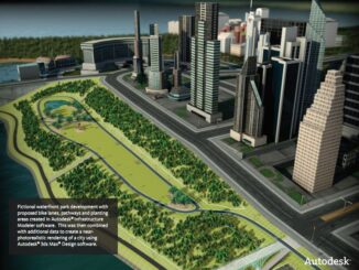
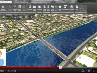
• facebook
  • Twitter
  • Linkedin
  • Youtube
  • Linkedin Group
  • Post a Job
  • Post an Ad
  • Post an Event
  • Post a Directory Listing
  • Post a Press Release
  • Media Kit
  • My Account
  • Login
GoGeomatics
  • MAGAZINE
    • BIM & GIS
    • Community
    • Conference news
    • Earth Observation
    • Education & Careers
    • GEOAI
    • Announcements
    • Reality Capture & Lidar
    • Science
    • Technology
    • Between the Poles
  • Directories
    • ASSOCIATION
    • INDUSTRY
    • EDUCATION
    • Open Data
  • EVENTS
    • GeoIgnite Events
    • Events Calendar
    • GoGeomatics Meetups
  • Services
    • Advertising
    • Marketing
    • Post a Job
    • Post an Ad
    • Post an Event
    • Post a Press Release
    • Post a Directory Listing
    • Media Kit
    • Web Design
  • Find a Job
  • Volunteer
    • Start a GoGeomatics Group
    • Editors & Writers Group
  • About Us
    • About Us
    • Contact Us
    • Frequently Asked Questions
  • Videos
HomeBetween the Poles – The Geoff Zeiss ArchivesDigital Cities

Digital Cities

3D Visualization

Autodesk releases Infrastructure Modeler 360 for the cloud

29 June 2012 Geoff Zeiss

Autodesk has released a new service as part of Autodesk 360, called Autodesk BIM 360.  One of the new tools in BIM 360 is a Conceptual Design and Feasibility Evaluation service, which enables users of […]

3D Visualization

Technical University of Berlin wins Oracle Spatial Excellence Award for CityGML

23 May 2012 Geoff Zeiss

Last week I blogged about an extension to the OGC CityGML standard for utilities.  Today at the Oracle Spatial User Conference the Institut für Geodäsie und Geoinformationstechnik – Technische Universität Berlin, where Thomas Kolbe and […]

Access to Spatial Data

Geospatial World Forum: Unlocking quality asset information at Heathrow

9 May 2012 Geoff Zeiss

Airports are like cities.  They have all the infrastructure that cities have plus some.  Heathrow is the busiest airport in Europe with on average 181,000 passengers passing through it each day.  Heathrow has 13 different […]

3D cadastre

Geospatial World Forum: Dutch 3D standard integrates CityGML/GeoBIM and large scale geography

28 April 2012 Geoff Zeiss

At the Geospatial World Forum in Amsterdam, Jantien Stoter of the Delft Univeristy of Technology and an advisor to Geonovum, gave an overview of the ongoing work on the Dutch 3D standard, which is being […]

3D Visualization

Integrated infrastructure management and urban planning at the City of Vancouver

21 April 2012 Geoff Zeiss

  Directions Magazine is hosting a webinar about how the City of Vancouver has implemented an integrated solution  focusing on urban planning and infrastructure management.  Jonathan Mark, Senior Manager GIS and CADD Services and Dan […]

3D Visualization

AU: Modeling cities in 2.5D at the City of Vancouver

5 December 2011 Geoff Zeiss

Dan Campbell is an urban planner at the City of Vancouver.  I’ve seen and heard several of Dan’s presentation over the past few years in Singapore, Bellevue, and other places and I always look forward […]

Between the Poles – The Geoff Zeiss Archives

Carbon Disclosure Project C40 expands to include world’s 150 most populous cities

10 November 2011 Geoff Zeiss

The Carbon Disclosure Project (CDP) is a global climate change reporting system.  Over 3,000 organizations in 60 countries measure and disclose their greenhouse gas emissions, water management and climate change strategies through CDP. The data is […]

3D Visualization

BIM for Infrastructure: Infrastructure Modeler available in more languages

1 November 2011 Geoff Zeiss

Earlier this year, Autodesk announced new software for conceptual design as part of its BIM for Infrastructure portfolio. Infrastructure Modeler represents the convergence of design, GIS and 3D visualization and is intended to help users […]

Posts pagination

« 1 … 5 6 7 … 11 »

Events

Sep 16
September 16 - September 17

Join ALL IN 2026, Montreal, Canada

Oct 26
October 26 - October 28

Canada’s National Geomatics Expo 2026

Oct 27
October 27 - October 29

Rendez-vous Géomatique 2026

View Calendar

View All Events

Services

  • Post a Job
  • Post an Ad
  • Post an Event
  • Post a Directory Listing
  • Post a Press Release
  • Media Kit
  • My Account
  • Login

Jobs

Post a Job
  • Volunteer Editorial Contributor – Be Part of Canada’s Geomatics Story
    Remote
  • Junior Geomatics Field Technician – Technical Surveys
    Montréal, QC
  • GIS Specialist
    Amherst, Nova Scotia
  • Precast Structural BIM Specialist
    Calgary, Alberta
View All Jobs
  • Directories
    • Associations Directory
    • Industry Directory
    • Education Programs
    • Open Data
  • Volunteer
    • Start a GoGeomatics Group
    • Editors & Writers Group
  • About Us
    • GoGeomatics Media Kit
    • Who We Are
    • Contact Us
    • FAQ’s
    • Advertising
    • Marketing
  • Subscribe
GoGeomatics
GoGeomatics is the largest and most popular communications hub promoting the Canadian geospatial community. The business was incorporated in 2011. GoGeomatics hosts over 100 fun, free, location technology networking events each year in cities across Canada.

© 2026 GoGeomatics

  • facebook
  • Twitter
  • Linkedin
  • Youtube
  • Linkedin Group