• facebook
  • Twitter
  • Linkedin
  • Youtube
  • Linkedin Group
  • Post a Job
  • Post an Ad
  • Post an Event
  • Post a Directory Listing
  • Post a Press Release
  • Media Kit
  • My Account
  • Login
GoGeomatics
  • MAGAZINE
    • BIM & GIS
    • Community
    • Conference news
    • Earth Observation
    • Education & Careers
    • GEOAI
    • Announcements
    • Reality Capture & Lidar
    • Science
    • Technology
    • Between the Poles
  • Directories
    • ASSOCIATION
    • INDUSTRY
    • EDUCATION
    • Open Data
  • EVENTS
    • GeoIgnite Events
    • Events Calendar
    • GoGeomatics Meetups
  • Services
    • Advertising
    • Marketing
    • Post a Job
    • Post an Ad
    • Post an Event
    • Post a Press Release
    • Post a Directory Listing
    • Media Kit
    • Web Design
  • Find a Job
  • Volunteer
    • Start a GoGeomatics Group
    • Editors & Writers Group
  • About Us
    • About Us
    • Contact Us
    • Frequently Asked Questions
  • Videos
HomeBetween the Poles – The Geoff Zeiss ArchivesDigital twin

Digital twin

3D data

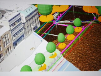
Above and underground infrastructure comprise Rotterdam’s open digital twin

6 July 2020 Geoff Zeiss

The City of Rotterdam is developing a digital twin of the city.  3D vector and image data of the above- and underground infrastructure, zoning regulations and city by-laws, data streams from real-time sensors, applications and […]

3D data

New OpenGround product for sharing underground geotechnical data achieves over 500,000 boreholes

28 October 2019 Geoff Zeiss

Unforeseen ground conditions are a major cause of delays in construction projects.  This year at the Year in Infrastructure event Bentley announced OpenGround a collection of applications for collecting, sharing, visualizing, analyzing, and accessing geotechnical […]

Between the Poles – The Geoff Zeiss Archives

Developing a roadmap for a reliable map of underground utilities in Singapore

21 October 2019 Geoff Zeiss

In 2017, the Singapore Land Authority (SLA), Singapore-ETH Centre, and the Geomatics Department of the City of Zürich started the Digital Underground project as a first step toward achieving an accurate, current, and complete map […]

Analytics

Is legacy GIS failing network infrastructure operating companies ?

24 July 2019 Geoff Zeiss

I thought it would be worthwhile to include here an expanded version of my contribution to a webinar that IQGeo presented last week with a provocative title that I think goes right to the nub […]

Between the Poles – The Geoff Zeiss Archives

Improving and sharing geospatial information about the subsurface in England

14 May 2019 Geoff Zeiss

NEDO estimates that about 50% of time over-runs on commercial building projects are caused by unforeseen ground conditions.* There are two aspects to the problems associated with the subsurface.  One is geotechnics, soil, ground water, […]

Asset management

Bringing reliable near real-time GIS within reach of every utility

12 March 2019 Geoff Zeiss

Workflows for ensuring utility GIS quality are fundamentally broken and have been for decades.  Integrating CAD and GIS into an efficient workflow has been a challenge and it has simply not been a priority in […]

3D data

Autodesk signals commitment to BIM + geospatial integration for improving construction productivity

21 February 2019 Geoff Zeiss

We are beginning to see data from real world projects that offer tangible evidence of the benefits of an integrated BIM+geospatial full lifecycle approach for construction projects.  A few firms such as Parsons Brinckerhoff, Atkins Global, […]

3D data

3D BIM + geospatial full lifecycle metro rail project aims at eliminating data loss

27 December 2018 Geoff Zeiss

This year’s winner of a special recognition award at Year in Infrastructure was Maharashtra Metro Rail Corporation Ltd for its Nagpur Metro Asset Information Management System which implemented a digital twin and a tagging scheme […]

Posts pagination

« 1 … 3 4 5 6 »

Events

May 3
May 3 @ 8:00 am - May 6 @ 5:00 pm

GEOINT Symposium 2026

May 11
May 11 @ 8:00 am - May 13 @ 5:00 pm

GeoIgnite 2026

May 25
May 25 - May 28

National Surveyors’ Conference 2026

May 27
May 27 @ 8:00 am - May 29 @ 5:00 pm

The Canadian Cartographic Association AGM

Jun 1
June 1 - June 4

CAG/CARTO Annual Meeting 2026

View Calendar

View All Events

Services

  • Post a Job
  • Post an Ad
  • Post an Event
  • Post a Directory Listing
  • Post a Press Release
  • Media Kit
  • My Account
  • Login

Jobs

Post a Job
  • Junior Geomatics Field Technician – Technical Surveys
    Montréal, QC
  • GIS Specialist
    Amherst, Nova Scotia
  • Precast Structural BIM Specialist
    Calgary, Alberta
  • Precast Structural Project Coordinator (BIM)
    Calgary, Alberta
View All Jobs
  • Directories
    • Associations Directory
    • Industry Directory
    • Education Programs
    • Open Data
  • Volunteer
    • Start a GoGeomatics Group
    • Editors & Writers Group
  • About Us
    • GoGeomatics Media Kit
    • Who We Are
    • Contact Us
    • FAQ’s
    • Advertising
    • Marketing
  • Subscribe
GoGeomatics
GoGeomatics is the largest and most popular communications hub promoting the Canadian geospatial community. The business was incorporated in 2011. GoGeomatics hosts over 100 fun, free, location technology networking events each year in cities across Canada.

© 2026 GoGeomatics

  • facebook
  • Twitter
  • Linkedin
  • Youtube
  • Linkedin Group