• facebook
  • Twitter
  • Linkedin
  • Youtube
  • Linkedin Group
  • Post a Job
  • Post an Ad
  • Post an Event
  • Post a Directory Listing
  • Post a Press Release
  • Media Kit
  • My Account
  • Login
GoGeomatics
  • MAGAZINE
    • BIM & GIS
    • Community
    • Conference news
    • Earth Observation
    • Education & Careers
    • GEOAI
    • Announcements
    • Reality Capture & Lidar
    • Science
    • Technology
    • Between the Poles
  • Directories
    • ASSOCIATION
    • INDUSTRY
    • EDUCATION
    • Open Data
  • EVENTS
    • GeoIgnite Events
    • Events Calendar
    • GoGeomatics Meetups
  • Services
    • Advertising
    • Marketing
    • Post a Job
    • Post an Ad
    • Post an Event
    • Post a Press Release
    • Post a Directory Listing
    • Media Kit
    • Web Design
  • Find a Job
  • Volunteer
    • Start a GoGeomatics Group
    • Editors & Writers Group
  • About Us
    • About Us
    • Contact Us
    • Frequently Asked Questions
  • Videos
HomeBetween the Poles – The Geoff Zeiss ArchivesEnvironment

Environment

Between the Poles – The Geoff Zeiss Archives

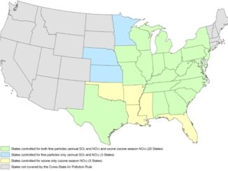
EPA rule on cooling water intakes finalized for existing power plants

6 June 2014 Geoff Zeiss

The U.S. Environmental Protection Agency (EPA) estimates that 2.1 billion fish, crabs, and shrimp are killed annually by being pinned against cooling water intake structures (impingement) or being drawn into cooling water systems and affected […]

Between the Poles – The Geoff Zeiss Archives

EPA’s Cross-State Air Pollution Rule for reducing power plant emissions reinstated

29 April 2014 Geoff Zeiss

On July 6, 2011, the US Environmental Protection Agency (EPA) finalized a rule designed to protect the health of Americans by reducing air pollution. The rule, which is known as the Cross-State Air Pollution Rule […]

Between the Poles – The Geoff Zeiss Archives

Long-term, free and open satellite Earth observation program launched by Europe

10 April 2014 Geoff Zeiss

April 3 Europe launched the first Sentinel-1A satellite of the €8.4-billion Earth monitoring Copernicus program, which is managed by the European Commission.  This was the first of a constellation of six Sentinel families which are […]

3D data

3D is transforming the construction industry and helping to build a new world

1 April 2014 Geoff Zeiss

Increasing urbanisation, pressure on existing infrastructure, push for productivity in construction sector and environmental concerns are driving the convergence of geospatial, 3D and information modeling technologies. Over the next two decades, construction of buildings and […]

Between the Poles – The Geoff Zeiss Archives

Canada’s emissions projected to miss Copenhagan reduction committment

27 October 2013 Geoff Zeiss

Canada signed the Copenhagen Accord in December 2009 and committed to reduce its greenhouse gas emissions to 612 Mt or 17 percent below 2005 levels (737 Mt) by 2020. Canada’s total greenhouse gas (GHG) emissions […]

Between the Poles – The Geoff Zeiss Archives

Australia’s GHG emissions from electricity generation down 6.1%

24 October 2013 Geoff Zeiss

The Quarterly Update of Australia’s National Greenhouse Gas Inventory for March Quarter 2013 has been released by Dept of the Environment.  Annual emissions for the year to March 2013 are estimated to be 557.0 Mt […]

Between the Poles – The Geoff Zeiss Archives

EPA 2012 emissions data for 8000 large emitters in the U.S. shows decrease of 4.5%

24 October 2013 Geoff Zeiss

The U.S. Environmental Protection Agency (EPA) has released annual greenhouse gas emissions data for 2012 collected under the Greenhouse Gas Reporting Program (GHGRP).  The program collects annual greenhouse gas information (CO2, CH4, N2O, SF6, NF3, […]

Between the Poles – The Geoff Zeiss Archives

Brazil uses satellite imagery to reduce illegal deforestation

12 September 2013 Geoff Zeiss

At the Latin America Geospatial Forum in Rio de Janeiro, Volney Zanardi Junior, president of the Brazilian Institute of Envrionment and Renewable Natural Resources (IBAMA) gave a very interesting overview of IBAMA and some of […]

Posts pagination

« 1 2 3 4 … 38 »

Events

May 11
May 11 @ 8:00 am - May 13 @ 5:00 pm

GeoIgnite 2026

May 25
May 25 - May 28

National Surveyors’ Conference 2026

May 27
May 27 @ 8:00 am - May 29 @ 5:00 pm

Canadian Cartographic Association Conference 2026

Jun 1
June 1 - June 4

CAG/CARTO Annual Meeting 2026

Jul 4
July 4 @ 8:00 am - July 11 @ 5:00 pm

ISPRS Congress 2026

View Calendar

View All Events

Services

  • Post a Job
  • Post an Ad
  • Post an Event
  • Post a Directory Listing
  • Post a Press Release
  • Media Kit
  • My Account
  • Login

Jobs

Post a Job
  • Leader, Utilities Surveying
    Calgary, Alberta
  • Field Technicians and Field Assistants
    Saskatoon, SK
  • Earth Science / GIS / Engineering co-op
    Saskatoon, SK and Vancouver, BC
  • Senior Analyst, Geographic Information System (GIS)
    Montréal
View All Jobs
  • Directories
    • Associations Directory
    • Industry Directory
    • Education Programs
    • Open Data
  • Volunteer
    • Start a GoGeomatics Group
    • Editors & Writers Group
  • About Us
    • GoGeomatics Media Kit
    • Who We Are
    • Contact Us
    • FAQ’s
    • Advertising
    • Marketing
  • Subscribe
GoGeomatics
GoGeomatics is the largest and most popular communications hub promoting the Canadian geospatial community. The business was incorporated in 2011. GoGeomatics hosts over 100 fun, free, location technology networking events each year in cities across Canada.

© 2026 GoGeomatics

  • facebook
  • Twitter
  • Linkedin
  • Youtube
  • Linkedin Group