
People who are familiar with AutoCAD know that AutoCAD Map 3D extends AutoCAD to support
- Geographic coordinate systems
- Support for geospatial vector and raster data
- Drawing cleanup such as duplicates, undershoots, and overshoots
- Creating thematic maps
- Accessing geospatial databases using FDO including ArcGIS, Oracle Spatial, and MySQL
- Surface rendering
- Publishing spatial to the Internet or creating map books
- Automating workflows
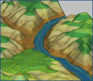 But many people may not be aware of AutoCAD Map 3D’s GIS analysis capabilities. Michael Schlosser has just published an article in Cadalyst that explains how you can perform GIS analysis using AutoCAD Map 3D and introduces some of Map 3D’s geospatial analysis capabilities including queries, thematic mapping, buffer analysis, topology analysis including network and overlay analyses, and 3D surfaces.
Be the first to comment