
Last week I had the opportunity to present at GITA Japan’s 19th annual conference, held this year at Tokyu University. I found it very well attended both vendors and service providers and utility and telecommunications companies. There were some very thought provoking presentations by international as well as Japanese speakers.
Introduction – Professor Sakura Shinoaki
Professor Shinoaki is well-known in Japan and in GITA because he was instrumental in designing the Road Administration Information Center (ROADIC) system which was deployed first in Tokyo and then in most major cities in Japan. I visited the ROADIC site in Tokyo several years ago and GITA sponsored a ROADIC Study Mission in 2003.
Thanks to the ROADIC system Tokyo in one of the few places in the world where there is a single location where you can find accurate maps of all outside infrastructure including telecommunications and utilities, and in what I would call 2.5D. The other cities I am aware of are Calgary and Edmonton, Alberta, and Sarajevo, Bosnia, where until recently the location of all utilities was recorded on paper maps. This has been done for the past 40 years. In the UK the Traffic Management Act, which received Royal Assent two years ago, but has only been implemented in April of this year, is a first step toward achieving a similar capability on a national scale.
The business benefits of a single site mapping all utilities and telecom infrastructure, for example, for call-before-you-dig services, are so compelling that I continue to be surprised that every jurisdiction has not mandated this. But I think that when you consider the additional benefits in a disaster situation such as Ike or Katrina in the US or the 2007 floods in the UK, I really think it is just a matter of time.
The Importance of Infrastructure Interdependencies – Bob Samborski
In 2004 GITA responded to Federal Government initiatives by beginning what became GITA’s Geospatially Enabling Community Collaboration (GECCo) to enhance a coordinated response to emergencies using geospatial data. Bob Samborski and Dave DiSera has been instrumental in this initiative and their presentations focussed on issues relating to critical infrastructure protection.
Perhaps the most startling slides that Bob showed was the size of the challenge in the US. The sheer numbers of facilities is staggering.
One of the very persuasive examples of the interdependence of critical infrastructure is the Baltimore Howard Street Tunnel train derailment. The derailment caused 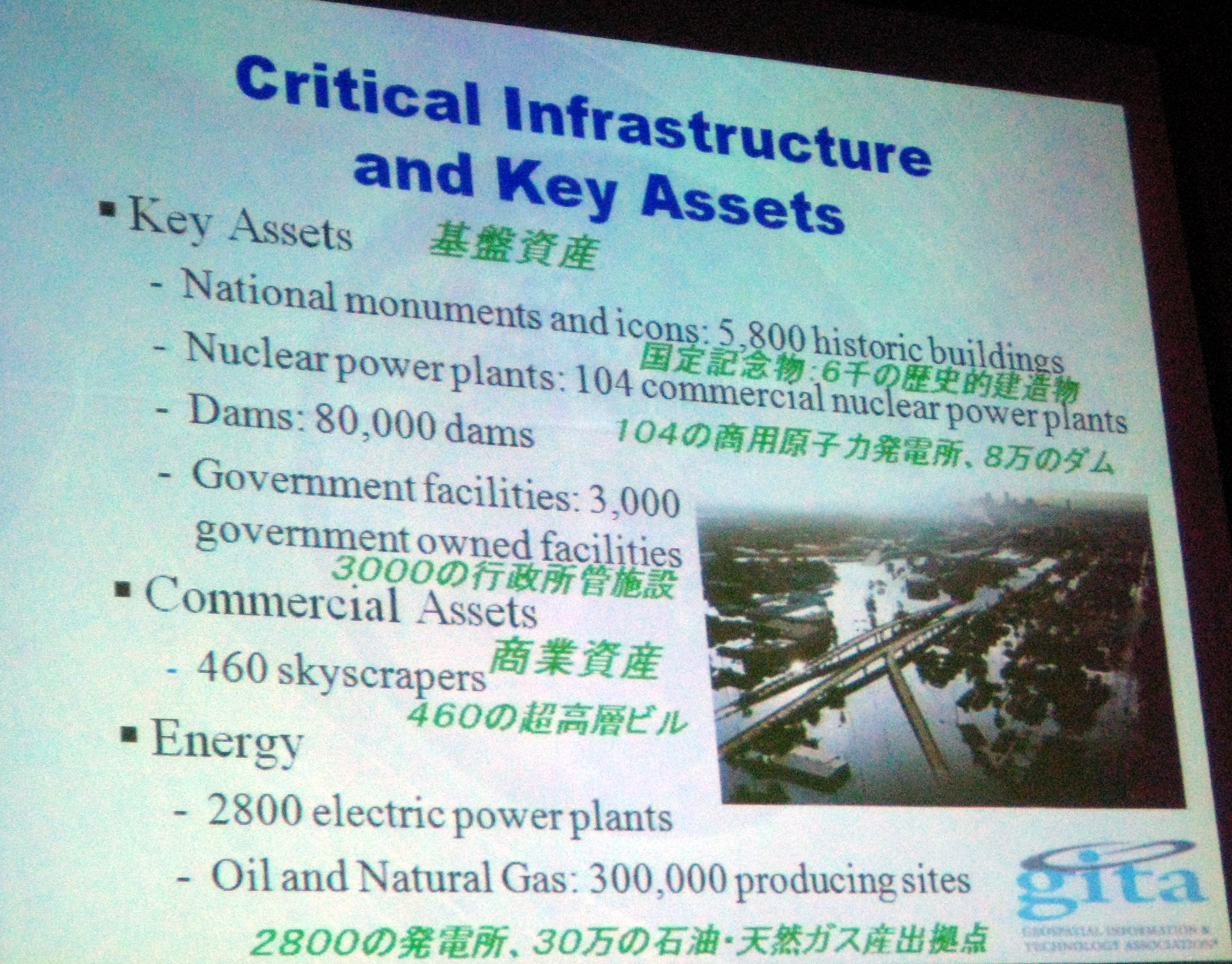 a fire, which lead to a water main fracture, which resulted in a flood, which led to a power outage which affected 100 000 people. As well a fibre optic cable running through the tunnel was destroyed, and train services was disrupted for a significant period of time with the result that coal could not be delivered to a thermal power plant, …
The Geospatial Dimensions of Critical Infrastructure – Dave DiSera
Dave discussed how proximity is an important factor in the interdependence of critical infrastructure and gave as one example a high voltage power line, a gas pipeline, and a waterway all within close proximity so that a major problem with the pipeline, for example, would most certainly impact power transmission and thereby a large number o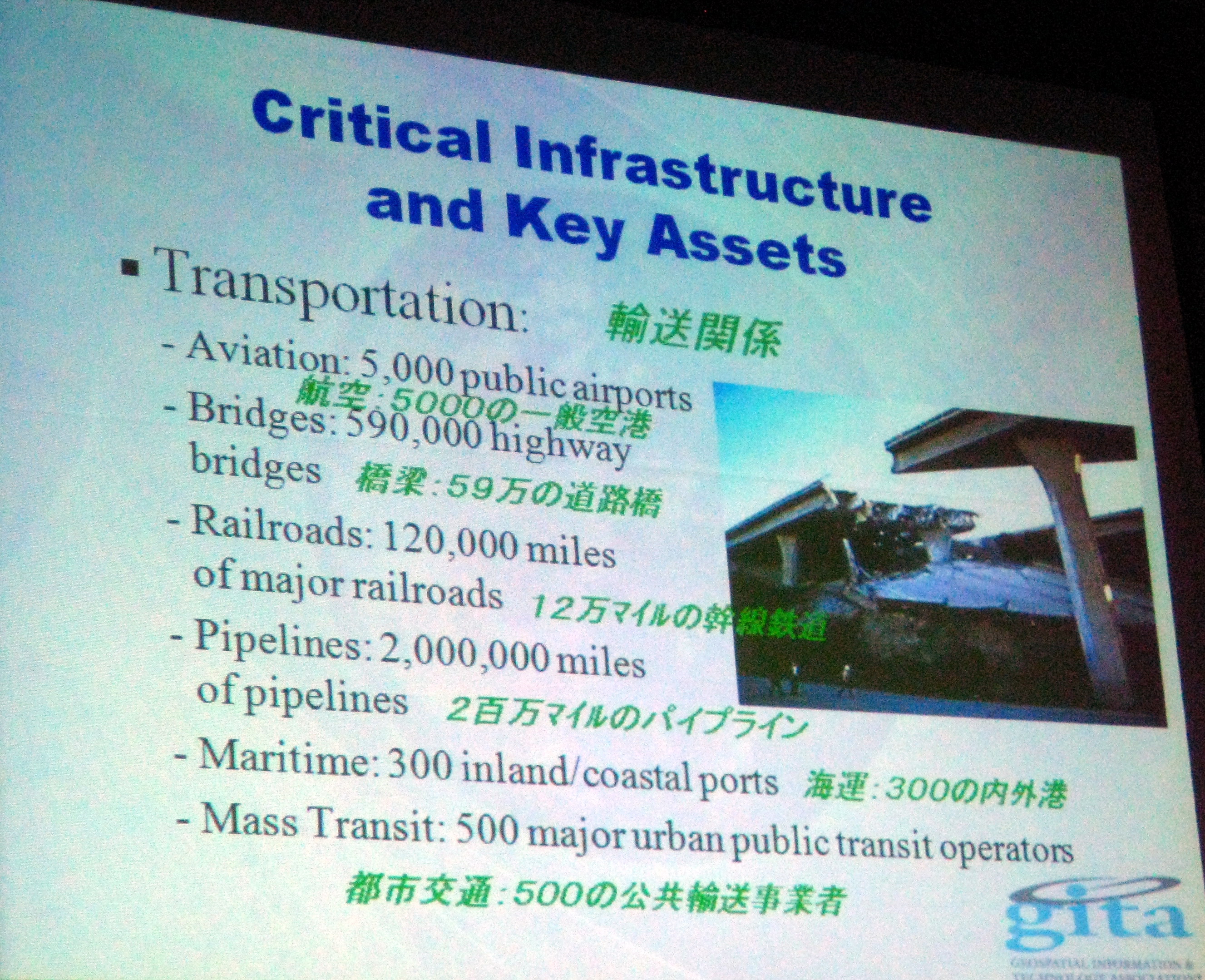 f people, as well as a significant transporation artery.
He also discussed models that have been developed for critical infrastructure interdependence by a number of organizations, but singled out those developed by Idaho National Lab, Argonne National lab, the Government of Canada, and Las Alamos National Lab.
An Overview of the Victorian Government Spatial Strategy…Initiatives and Issues – Neil Smith
Neil Smith is with the Department of Transportation of the Victorian Government. I have blogged previously about the industry leading initiatives in the area of spatial data sharing by the Victorian Government. Neil provided insight into the organizational structure of the Victorian Government that have enabled these initiatives to happen. But the thing that Neil talked about that really rang a bell with me is how pervasive data redundancy is within governments, indeed organizations, everywhere. The concepts of a single point of truth and custodianship appear to be the central foundation on which Victorian Government is attempting to do to address the problem of data redundancy.
Geographical Survey Institute – Yamato Tanaka
One of the interesting presentation in Japanese that I only partly understood was by Yamato Tanaka who talked about an initiative at the Federal government level to create a shared database that integrates geospatial data from all levels of data including Prefectural and Municipal. From what I understood tallking to people in local government is Japan, one of the challenges is how this effort is going to be funded, by the Federal government or my local government. It struck me that there are there are analogies with the attempt by DHS to create and implement a common data model GDM for sharing geospatial data at the state and local level in the US.
Crumbling Infrastructure
I’ve blogged several times about crumbling infrastructure in North America and the score card prepared by the American Society of Civil Engineers assessing the state of US infrastructure. I mentioned this during my presentation in Japan and I was surprised to learn that there is a similar effort going on in Japan. I say surprised, because Japanese infrastructure, at least what I have seen of Japanese streets, roads, and highways, and electric infrastructure, appears to be so much better maintained that what we are famliiar with in much of North America, both in the US and Canada.
UMPC for utilities
Finally, I’ll mention that I have been interested in UMPCs for several years. I have carried an OQO around with me for several years. I’ve blogged about UMPCs and have encouraged utilities and telecommunications firms that I meet with to take a look at them. At least two vendors at GITA Japan were showing mobile applications running on handheld devices. The one I looked at was running on a Fujitsu U810 with a 5.6″ screen, 40 GB h/d and running Vista. Quite an impressive small device for about C$1200 which is about US$1000 these days, much cheaper than Panasonic Toughbooks, the standard mobile device for many utilities, that cost 4X to 6X times more.

Be the first to comment