
I was at GITA Ontario Fall Forum yesterday near Toronto, which is an event I look forward to every year. This year was no exception, there was some exceptionally good content especially in the electric power utility area.
Every year I have a chance to catch up with some folks that are developing and deploying geospatial applications in Ontario, a province with about 10 million people. This time I spend some time chatting with Scott MacPhee, Web Applications Engineer at Hunter GIS, which develops web-based geospatial applications for the municipal, utility, telco and resource management sectors using Autodesk MapGuide 6.5, MapGuide Open Source, and MapGuide Enterprise. They have developed several applications for local governments including tax parcel assessment, municipal permit tracking, development tracking, water and sewer asset management, gas infrastructure management, electrical infrastructure management, and environmental and natural resource management. One of the applications they have developed is a Road Asset Management System (RAMS), a comprehensive, web-based road asset management systems that allows municipal road departments to manage inventories and inspections, maintain an asset database including roads, bridges, culverts, signs, and lights,and help with prioritization and budgeting. RAMS integrates with the parcel tax assessment database, automatically computes ratings, needs and resurfacing/rehabilitation costs, and allows you query the roads database for spatial analysis of road conditions. RAMS has been in use for some time by local governments in Ontario.
I have blogged about the poor quality of network facility data in utilities and telecom, how critical up to date reliable network facility data is becoming, and how essential it is to use technology to empower field staff 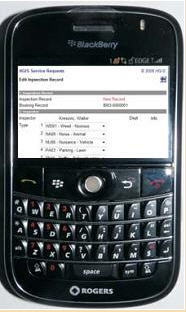 to be full participants in improving the quality of asset data. What Hunter GIS has done is develop a simple online web-based application that can be used by field staff to report to report the condition of road facilities. Scott showed me a mobile extension to RAMS that provides field access to RAMS databases via a Blackberry or other wireless handheld device. This means that field staff can view and select assets graphically, list all the assets on a street, view inspection reports on road assets, create a new inspection report, for example, report a pot hole, and attach a photograph all from a Blackberry. Impressive. I fully expect that in the future they are going to find rapidly increasing use of handheld devices for these types of applications and proportionately less use of desktops. Hunter GIS also have mobile solutions for municipal permit tracking and service request tracking.

Be the first to comment