
The extent of Arctic sea ice is one of the most accessible sources of data showing the effect of global climate change. The National Snow and Ice Data Center (NSIDC) began monitoring Arctic sea ice extents in 1978 using passive microwave satellites (NSIDC Near-Real-Time DMSP SSM/I Daily Polar Gridded Sea Ice Concentrations and the Sea Ice Concentrations from Nimbus-7 SSMR and DMSP SSM/I Passive Microwave) at a resolution of 25 km. September 2007 was the lowest summer Arctic sea ice extent observed since NSIDC began monitoring and recording sea ice extents in 1978. To see an animation of observed sea ice extents for September from 1979 through 2008, go to this site and select
- Northern hemisphere,
- 1979
- September
- Sea Ice Extent
- check Fixed Month Animations.
A recent article, which extrapolated Arctic sea ice extents back to 1200 CE using a combination of regional tree-ring chronology from the timberline area in Fennoscandia and δ18O from the Lomonosovfonna ice core in Svalbard calibrated for the period 1864–1997, suggests that the 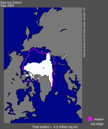 present low sea ice extent is the lowest over the last 800 years and began with a decline starting in the late-nineteenth century after the so called Little Ice Age (LIA) from the seventeenth to the nineteenth centuries, when the largest sea ice extent values occurred. Last year the Northwest Passage was ice free in the summer for the first time in history. Right now the Arctic is in the midst of the summer melt season. Through June ice extent tracked below the 1979 to 2000 average, and slightly above the levels recorded during June 2007.
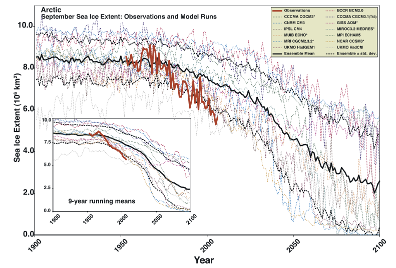 An article published in 2007 by Julienne Stroeve and co-workers at NSIDC has suggested that the IPCC models are too conservative in their estimates that the Arctic will become completely ice-free in the summer during the second half of this century or later. On average, the IPCC models suggest a trend that is three times smaller than what has been observed. The observed rate indicates that sea ice conditions for September are about thirty years ahead of where the models predict and suggest it is likely that the Arctic will be ice free in the summer during the first half of this century.

Be the first to comment