
Absolutely amazing. High Line Park in the Lower West Side in Manhattan was opened by Mayor Bloomberg, Diane von Furstenberg, and others. It is 30 feet (10 meters) above street level and is a converted old West Side Line railway viaduct.
This is the latest in the grand tradition of “brownfield park development” in New York. New York was pretty unique in the world in 1853 when 700 acres of populated land was acquired for what become Central park. (Interestingly, Central Park was decrepit when Mayor Laguardia was elected in 1934 and gave Robert Moses the job of cleaning it up which he did using funds from President Roosevelt’s New Deal as well as private donations.)
High Line Park has been 10 years in the making and was funded by a combination government agencies and private contributions including $10 million donated by Diane von Furstenberg.
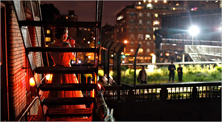 An enterprising apartment dweller has taken advantage of her proximity to the very popular park to present High Line Park Renegade Cabaret, written up in the New York Times (Image from the New York Times).
 There is a series of videos about High Line Park and how it was developed on www.sundancechannel.com.
I blogged about the new (green) Street Design Manual that the New York DOT recently released. The green revolution really seems to be beginning to reverse the legacy of Robert Moses’ Triborough Commission and to transform New York into a nicer place for human beings, rather than cars, to live.

Be the first to comment