Most of the world’s vector spatial data is captured using CAD desktop applications, whether we are talking about engineering design data or traditional geospatial data. Over the past 20 or so years most of the utility and telecommunications enegineering design data for outside facilities have been converted to electronic form, either by the utilities and telcos themselves or more often by conversion vendors, who invariably use CAD desktop applications to capture network facilities data from paper drawings.
Utilities and telecommunications have been facing problems arising from the inefficient flow of engineering design data from designers to the construction subcontractors to records (outside of North America referred to as network documentation) and between records and operations. The problems that can be attributed to what is really a pathological paper-based information flow include poor data quality, redundant data, inefficient field operations, and others. I’ve bloggedseveral times about this in the past. In many utilities and telcos the records department redigitizes from paper as-builts the same data that was created in electronic form by engineering. This is the source of a number of problems including as-built backlogs, data errors, and the inefficient use of valuable staff.
At the WAURISA conference this week Brad Hofman of Snohomish County and Dusty Gallinger of The PPI Group gave an outstanding presentation that addressed the issue of repurposing intelligent engineering design data for GIS, asset management, and other downstream uses.
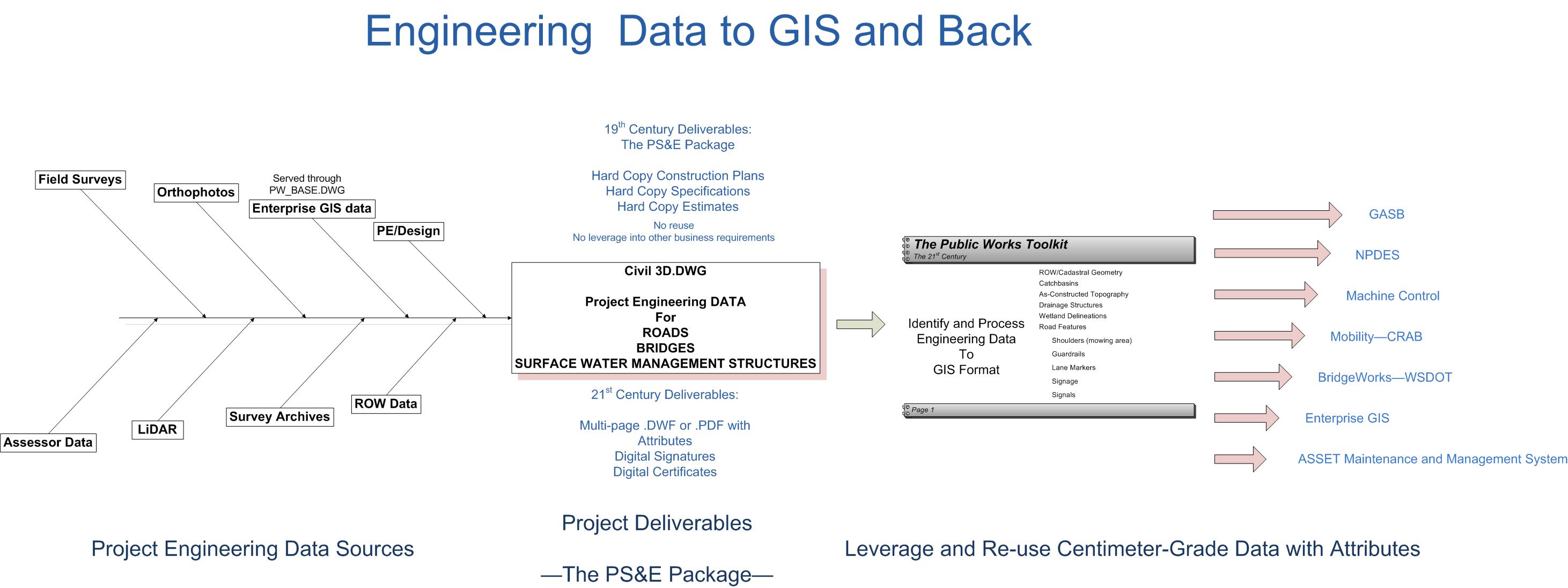
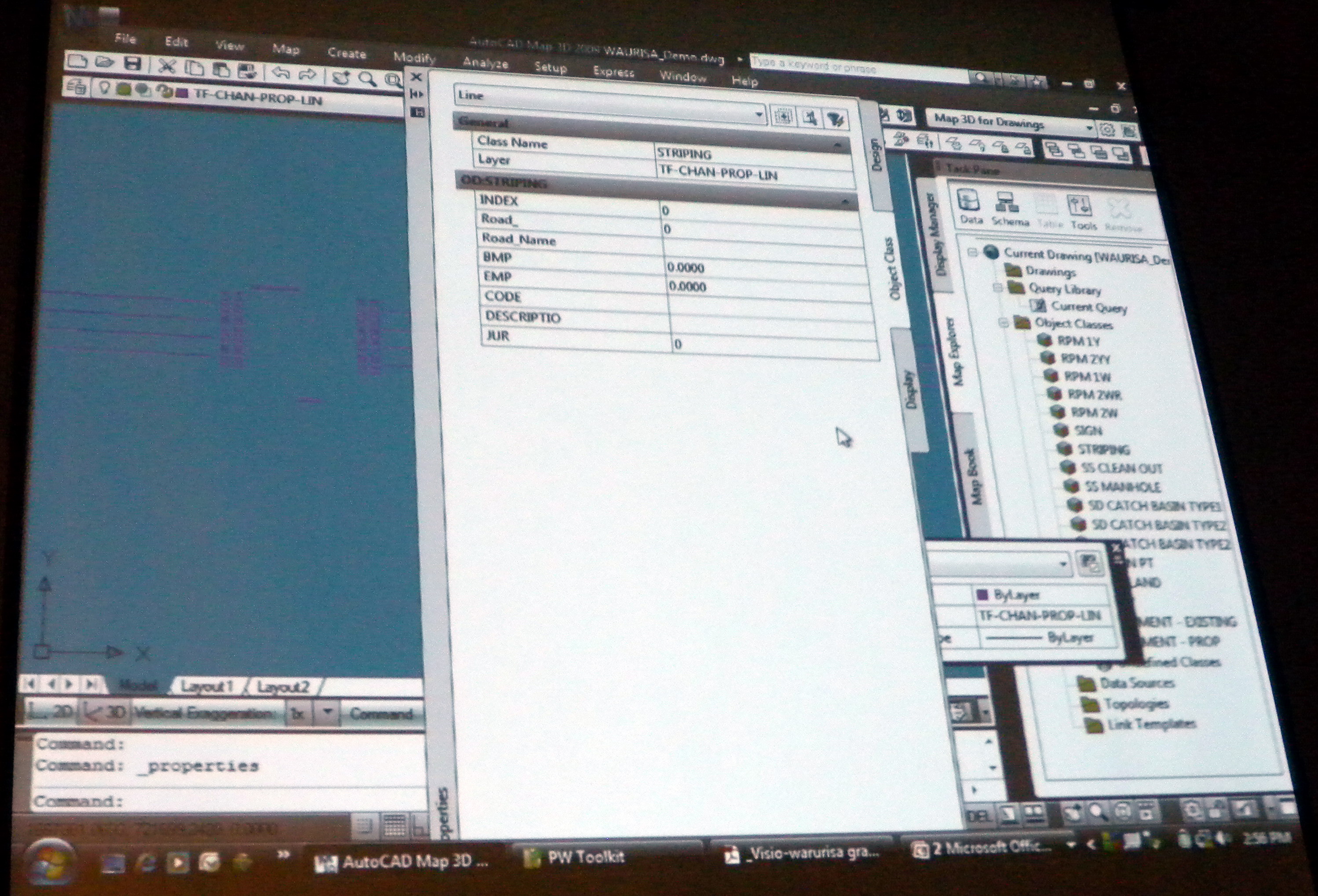
PPI is developing a toolkit, based on AutoCAD Map 3D and FDO, called the Public Works Toolkit (PWT) which is designed to help Snohomish County as part of their day-to-day workflow repurpose their engineering design data and avoiding redigitizing from paper. The PWT creates an AutoCAD-based environment where design data can be classified as striping, easements catch basins, signs, and so on. This enables Snohomish County to get a lot more value from their engineering design data by repurposing it for downstream uses such as GASB, NPDES, machine control, mobility-CRAB, bridgework – DOT, enterprise GIS, and asset maintenance and management. Brad sees the PWT as having broad applicability including State of Washington Public Works Departments, other county Public Works Departments, the Washington County Road Administration Board, DOTs, consultants, and developers.
I think Brad really hit the nail on the head when he said “It’s amazing to me after all these years that it isn’t generally understood that the data we produce for civil engineering construction plans aren’t just plot files to drive a printer, but are actually rich datasets of survey grade vector geometry, and objects that can be densely attributed with location, materials, maintenance and other data.”
There were many questions from the audience relating to the availability of the PWT. Dusty responded that the PWT is a work in progress, but that PPI is planning to host a PWT workshop in the summer for people who are interested in finding out more about the PWT.
Geoff Zeiss
Geoff Zeiss has more than 20 years experience in the geospatial software industry and 15 years experience developing enterprise geospatial solutions for the utilities, communications, and public works industries. His particular interests include the convergence of BIM, CAD, geospatial, and 3D. In recognition of his efforts to evangelize geospatial in vertical industries such as utilities and construction, Geoff received the Geospatial Ambassador Award at Geospatial World Forum 2014. Currently Geoff is Principal at Between the Poles, a thought leadership consulting firm. From 2001 to 2012 Geoff was Director of Utility Industry Program at Autodesk Inc, where he was responsible for thought leadership for the utility industry program. From 1999 to 2001 he was Director of Enterprise Software Development at Autodesk. He received one of ten annual global technology awards in 2004 from Oracle Corporation for technical innovation and leadership in the use of Oracle. Prior to Autodesk Geoff was Director of Product Development at VISION* Solutions. VISION* Solutions is credited with pioneering relational spatial data management, CAD/GIS integration, and long transactions (data versioning) in the utility, communications, and public works industries. Geoff is a frequent speaker at geospatial and utility events around the world including Geospatial World Forum, Where 2.0, MundoGeo Connect (Brazil), Middle East Spatial Geospatial Forum, India Geospatial Forum, Location Intelligence, Asia Geospatial Forum, and GITA events in US, Japan and Australia. Geoff received Speaker Excellence Awards at GITA 2007-2009.


Be the first to comment