
One of the things that strikes many visitors from Europe is the concrete and asphalt wasteland of many North American cities, which were built primarily with commerce in mind. Robert Moses of the Triborough Bridge Commission is often the single person identified as the source of the modern American city. “His critics claim that he preferred automobiles to people, that he displaced hundreds of thousands of residents in New York City, uprooted traditional neighborhoods by building expressways through them, contributed to the ruin of the South Bronx and the amusement parks of Coney Island, caused the departure of the Brooklyn Dodgers and the New York Giants Major League baseball teams, and precipitated the decline of public transport through disinvestment and neglect.” [Wikipedia] On more than one occasion in several American cities I have been in a hotel literally 100 meters from a customer location and have had to take a cab to get there because there is no way to walk there short of playing “chicken” on a freeway.
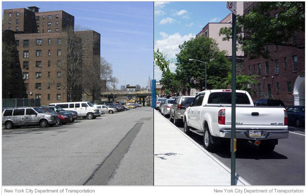 Now New York is leading the charge in the opposite direction. Mayor Bloomberg’s administration is issuing a set of guidelines for transforming New York streets from Moses’ model to a more European style city model. Based on the Bloomberg administration’s new manual the New York City Department of Transportation will review new development plans to determine whether they align with the new street design guidelines. The manual, called the Street Design Manual, is the result of nearly two years of work led by the NYC Department of Transportation. In New York streets cover a quarter of the city’s land area and provide the bulk of New York City’s public space. According to the New York Times, “urban planners say that the document is long overdue, and that it promises to be as much a map to the future as it is a handbook for the present: getting people to think about streets as not just thoroughfares for cars, but as public spaces incorporating safety, aesthetics, environmental and community concerns.”
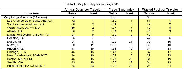 It may also mean that fewer people will have to spend up to four hours a day sitting in traffic.[2007 Annual Mobility Report] According to the American Society of Civil Engineers (ASCE), Americans spend 4.2 billion hours a year stuck in traffic at a cost of $78.2 billion a year in wasted time and fuel costs, about $710 per motorist.
 - The average daily percentage of vehicle miles traveled under congested conditions rose from 25.9% in 1995 to 31.6% in 2004, congestion in large urban areas exceeding 40%.
- As a result of increased congestion, total fuel wasted climbed from 1.7 billion gallons in 1995 to 2.9 billion gallons in 2005.
It may also mean fewer highway fatalities and injuries. According to the ASCE, in 2007, 41,059 people were killed in motor vehicle crashes and 2,491,000 were injured. Motor vehicle crashes cost the U.S. $230 billion per year, about $819 for each resident in medical costs, lost productivity, travel delays, workplace costs, insurance costs, and legal costs.

Be the first to comment