
I spend a lot of time in many countries around the World and it is really fascinating how the availability of geospatial data is changing dramatically. There are a number of reasons for this.
Accessibility
Geospatial data is also much more
accessible than ever before thanks to the Web. All of the mass market
web vendors, Google, Microsoft, Yahoo, and AOL MapQuest provide web
access to geospatial data and most enable users to integrate their own
geospatial data via mashups. Google tends not to collect its own data,
but to provide access to commercial data from commercial data vendors.
Also Google has been encouraging governments to make their data
available through Google’s applications. Microsoft on the other hand spends a lot
of money to collect geospatial data.
One of the things that software entrepreneurs need to be aware of is that if they develop an application that uses commercial data from Google, Microsoft, Yahoo, or MapQuest, they need to read the fine print and may have to work out an agreement with the vendor, just like they would with Digital Globe or another data provider.
Commercial Geospatial Data Providers
The rise of commercial geospatial data providers like Radarsat, Intermap, TeleAtlas, Navteq, Digital Globe, GeoEye, and the Ordnance Survey (UK) has dramatically increased the volume and quality of geospatial data. Every year the number of earth observation satellites increases and resolution improves. In the past year, we have seen the launch of Radarsat II, GeoEye I, Worldview I, Theos, and others. You can find data from some of these vendors at this location.
There are also new technologies such as high resolution photogrammetry from companies such as Vexcel (now Microsoft) and Pictometry, and laser scanning, terrestial, mobile, and LIDAR.
The result is that the quality of geospatial data is improving and the sheer volume is going up exponentially.
Open Geospatial Data
Another contributor to the increasing availability of geospatial data is the exponential growth in open geospatial data, the data equivalent of open source in the programming realm. There are key technologies that have enabled this to happen. GPSs have become so inexpensive that geospatial data acquisition is now accessible to virtually everyone. Secondly, the Web 2.0 phenomenon has enabled the widespread sharing of user content, in this case geospatial data collected by you and me.
But equally important are open geospatial data licensing, which defines the legalities (intellectual properties rights or IPR) for sharing open geospatial data, and the open geospatial data pricing model that determines how much it is going to cost you and me. Open geospatial data derives from two sources, government and what I’ll call non-government open geospatial data organizations, which tend to follow a Web 2.0 model, where the data is collected and contributed by users, typically equipped with a GPS.
A motivation for geospatial software entrepreneurs to be interested in open geospatial data is open access. If you develop a web application that requires geospatial data and
you use TIGER or OpenStreetMap data you can deploy your application to
the web and be pretty confident that you are not infringing on anyone’s copyright.
If you want to do this with geospatial data from Google Earth,
Microsoft Virtual Earth, Yahoo, or MapQuest, you need to read the fine print and may have to
work out an agreement with the vendor or the data provider.
Government: US
In the US, geospatial data collected by the Federal government is available at no cost and is in the public domain, which means you can do what you like with it including derivative works and resale. The best known example is TIGER data collected by the US Census.
Government: California
In the US at the state and local government level, the situation is
quite different and data collected by local governments is still
characterized by a variety of business models. However, there is now an
important precedent in the State of California. The California Public Records Act (CPRA) requires that state and local government records should be accessible to anyone requesting them for no more than the cost of duplication. The Attorney General of California issued an official opinion to the effect that digital parcel data is covered by the CPRA. The California First Amendment Coalition (CFAC) took one of the counties in California to court after the county denied CFAC’s request for the county’s parcel basemap data at the (nominal) cost of copying. The California Superior Court for Santa Clara County supported CFAC and directed the county to provide the parcel basemap data to CFAC charging only for the cost of duplication. So there is now a legal precedent in California for free access to geospatial data.
Government: Canada
As of April 1, 2007, geospatial data from Natural Resources Canada and other Federal, Provincial, and Territorial Governments is available for free, subject to a (made in Canada) license. That there is a license reflects an important difference between the US on one hand and and British Commonwealth countries like Canada, Australia, New Zealand, and South Africa on the other, in that in the latter all government data is automatically covered by crown copyright.
Government: Japan
In Japan Government Federal government data is available from the Geographical Survey Institute (GSI) at a nominal charge. High quality data is maintained by the the GSI which has an annual budget for collecting and maintaining this data. Recently, what is called a Basic Law was passed by the Japanese Diet establishing the principle that data collected by the government should be available to the public at nominal cost.
Government: South Africa
As in Canada all data is covered by crown copyright. In South Africa the National Government has adopted the principle that digital geospatial data is freely available.
Government: Netherlands
In the Netherlands some geospatial data collected by the government appears to be available for free. But it’s not clear. For example, currently local government, municipalities, and engineering companies have to pay for the topographic maps and Large Scale Base Maps (called GBKN ) that are maintained by the Dutch Cadastre. There is also Basiskaart On Line; a WMS-service for GBKN maps that you are required to pay for.
Government: Australia
As in Canada all Government data is covered by crown copyright, but because of a variety of licenses and the lack of licences, it is difficult to share geospatial data even between departments within government.
Government: Victoria
Based on the 2008 Victorian Spatial Information Strategy, the State Government has initiated a Framework for Sharing, which has been developed by the Victorian Spatial Council. It comprises a framework of licenses and metadata and incorporates the concept of custodianship. It is inclusive and is not restricted to government, including besides the State Government, utilities, telecommunications firms, the National Government,
other government, quasi-government, and non-government organizations. At this point it is a voluntary program, and it does not mandate a particular licensing or pricing model.
Government: Queensland
In Queensland there is an initiative by the State Government to create a foundation for sharing geospatial data within the government. The focus of this initiative is a common licensing model, and the really innovative recommendation that has been made is to implement Creative Commons licensing. Creative Commons is widely used for books, music, and other media and includes six different licenses including Creative Commons Attribution-Share Alike, which is analogous to Gnu Public License (GPL) in the open source world.
Non-Government
GPS technology has enabled a third type of geospatial data collection organization, which is non-governmental and relies primarily on user collected and contributed geospatial data. The two I am most familiar with are MalSingMaps.com and OpenStreetMap.
MapSingMaps provides Garmin compatible road and highway geospatial data collected by members for Singapore and Malaysia. It is free for personal use, but it is copyrighted and derivative products are expressly not permitted.
OpenStreetMap
Currently probably the best
known non-government open geospatial
data site is OpenStreetMap
I heard a
presentation from OpenStreetMap at Intergeo in Bremen, Germany and I
was impressed by the volume of data that has been collected, their
World coverage, and by the rate at which new data is being collected.
The total number of registered users is 65 000, of which 10% were active in the last month. Worldwide 268 million nodes and 21 million ways have been collected. There appears to be coverage in North America, Europe, Australia, Philippines, and Argentina. 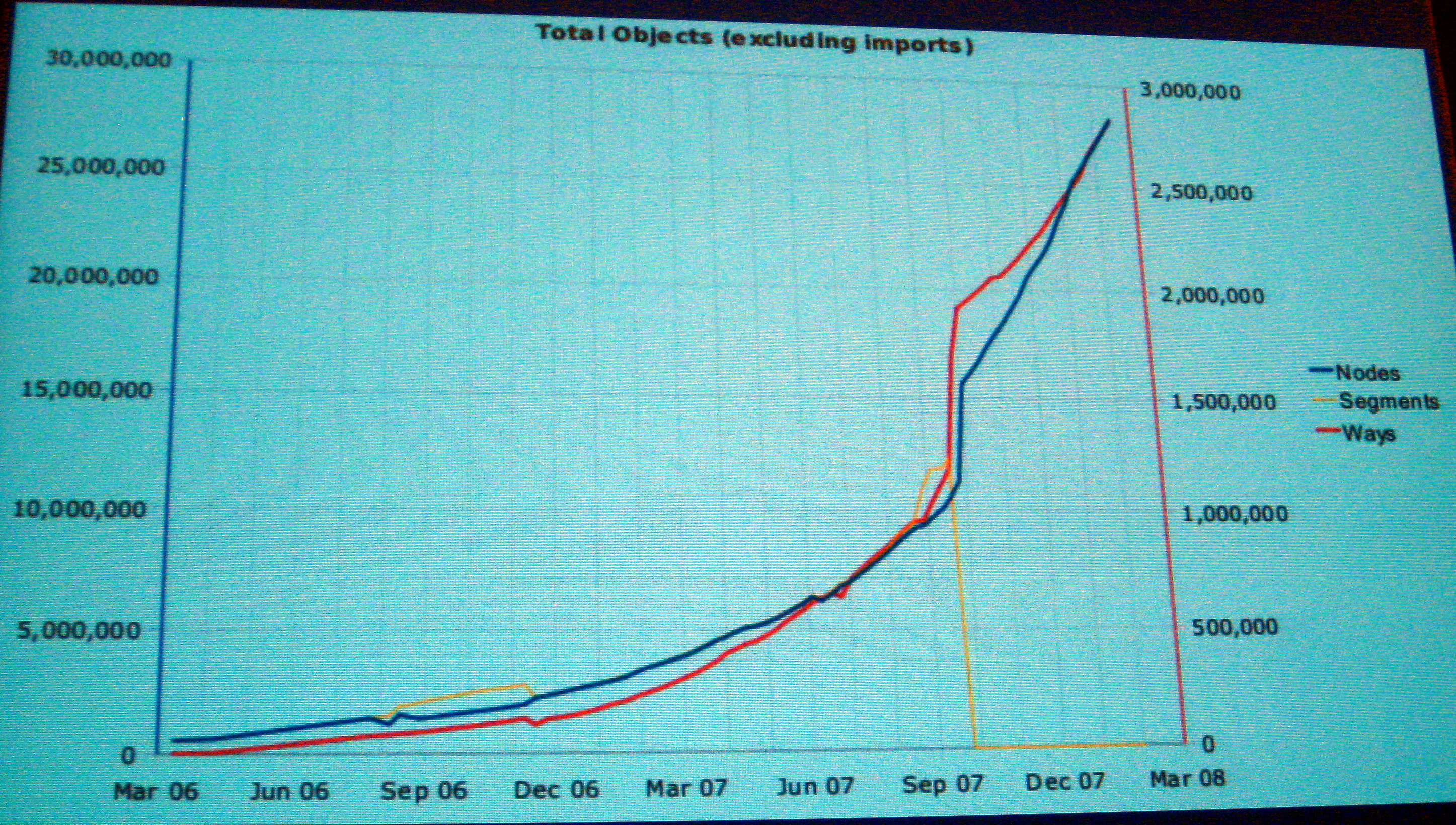
As you can see from the second slide the volume of OpenStreetMap data appears to be increasing dramatically.
OpenStreetMap data is “a free editable map of the whole world” and “allows you to view, edit and use geographical data in a collaborative way from anywhere on Earth.” It’s IPR is covered by the Creative Commons Attribution-Share Alike license.
With respect to licensing there has been a discussion within the OpenStreetMap community about a new license that is specifically tailored for geospatial data. I believe that two issues with CC licensing motivated this initiative. The first is the need to distinguish between collective and derivative work for geospatial data. More often than not, when you’re working with geospatial data you are using more than one dataset which represents a collective work. The second motivation is that in some jurisdictions, geospatial data is not copyrightable. The new OpenStreetMap license means that in the immediate future we will have three different types of open licenses for source code, creative media, and geospatial data.
Future of Open Geospatial Data
Probably the most important technical innovation that has enabled the proliferation of open geospatial data is the availability of inexpensive GPSs. If you look at the decreasing cost of terrestial laser scanners and the geospatial data collection techniques that are being developed using low cost digital cameras, it seems to me highly probably that we can expect an explosion of open geospatial data.

Be the first to comment