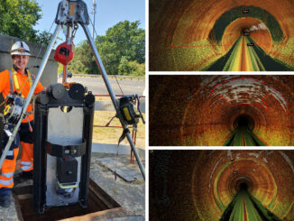
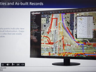
• facebook
  • Twitter
  • Linkedin
  • Youtube
  • Linkedin Group
  • Post a Job
  • Post an Ad
  • Post an Event
  • Post a Directory Listing
  • Post a Press Release
  • Media Kit
  • My Account
  • Login
GoGeomatics
  • MAGAZINE
    • BIM & GIS
    • Community
    • Conference news
    • Earth Observation
    • Education & Careers
    • GEOAI
    • Announcements
    • Reality Capture & Lidar
    • Science
    • Technology
    • Between the Poles
  • Directories
    • ASSOCIATION
    • INDUSTRY
    • EDUCATION
    • Open Data
  • EVENTS
    • GeoIgnite Events
    • Events Calendar
    • GoGeomatics Meetups
  • Services
    • Advertising
    • Marketing
    • Post a Job
    • Post an Ad
    • Post an Event
    • Post a Press Release
    • Post a Directory Listing
    • Media Kit
    • Web Design
  • Find a Job
  • Volunteer
    • Start a GoGeomatics Group
    • Editors & Writers Group
  • About Us
    • About Us
    • Contact Us
    • Frequently Asked Questions
  • Videos
HomeBetween the Poles – The Geoff Zeiss Archives

Between the Poles – The Geoff Zeiss Archives

3D data

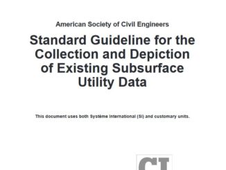
Standards for underground location quality are rapidly evolving

24 February 2021 Geoff Zeiss

In the last two years quality standards for location quality of underground infrastructure in the U.S., Canada, U.K. and Australia have been revised or augmented.  This reflects the accelerating development of new technologies and evolution […]

Between the Poles – The Geoff Zeiss Archives

British Columbia’s ICI Society provides province-wide shared map of underground utilities

16 February 2021 Geoff Zeiss

The only instance I know of in North America of a province or state wide database that includes maps of utility infrastructure is the Integrated Cadastral Information Society (ICI Society) in British Columbia. The ICI […]

3D data

Applying quantum effects to detecting underground infrastructure

8 February 2021 Geoff Zeiss

Many of the technologies for detecting underground utilities and other infrastructure involve shooting some type of signal, electromagnetic or acousic, into the ground and measuring the reflection off underground objects.  A major challenge for these […]

Between the Poles – The Geoff Zeiss Archives

Priorities for UK underground utility locating: Better pre-construction preparation and more accurate utility plans

3 February 2021 Geoff Zeiss

The Utility Strike Avoidance Group (USAG) has released its 2019 report on underground utility damage in the U.K. The analysis found that inadequate assessment of planned excavations in the pre-construction phase has grown significantly as […]

Between the Poles – The Geoff Zeiss Archives

Priorities for the underground locate industry: white-lining and better utility maps

1 February 2021 Geoff Zeiss

According to statistics compiled by the Common Ground Alliance (CGA) the process by which underground utilities are located (detected and marked) are responsible for 28% of incidents of damage to underground infrastructure during excavation. To […]

3D data

Applying inertial locating technology to mapping and condition assessment of large deep assets

26 January 2021 Geoff Zeiss

Knowing where things are underground has become important enough that in a number of jurisdictions around the world including the Netherlands, Singapore, and the U.K., initiatives are underway to create national digital twins which include […]

3D data

Inertial locating to accurately map LIVE underground gas distribution utilities is a game changer

20 January 2021 Geoff Zeiss

Inertial locating is an innovative technology that is used to accurately map underground pipe networks.  But to date the technology has required non-pressurized pipes.  Now a PHMSA-sponsored project has demonstrated that the technology can be […]

3D data

Colorado builds a high accuracy database of the location of underground assets in the public right of way

18 January 2021 Geoff Zeiss

New regulations were released January 14 by the Colorado Department of Transportation (CDoT) that mandates (1) the electronic submission of high accuracy plans showing the location of of underground infrastructure prior to commencing a construction […]

Posts pagination

« 1 … 10 11 12 … 314 »

Events

Notice
There are no upcoming events.

View All Events

Services

  • Post a Job
  • Post an Ad
  • Post an Event
  • Post a Directory Listing
  • Post a Press Release
  • Media Kit
  • My Account
  • Login

Jobs

Post a Job
  • GIS Technologist II
    Fernie, B.C.
  • GIS I TECHNOLOGIST
    Fernie, B.C.
  • Survey Crew Chief
    Langley, BC
  • Survey Tech
    Kamloops, BC
View All Jobs
  • Directories
    • Associations Directory
    • Industry Directory
    • Education Programs
    • Open Data
  • Volunteer
    • Start a GoGeomatics Group
    • Editors & Writers Group
  • About Us
    • GoGeomatics Media Kit
    • Who We Are
    • Contact Us
    • FAQ’s
    • Advertising
    • Marketing
  • Subscribe
GoGeomatics
GoGeomatics is the largest and most popular communications hub promoting the Canadian geospatial community. The business was incorporated in 2011. GoGeomatics hosts over 100 fun, free, location technology networking events each year in cities across Canada.

© 2026 GoGeomatics

  • facebook
  • Twitter
  • Linkedin
  • Youtube
  • Linkedin Group