The Premier of Ontario has announced that the Province has committed to protect 50% of the Province’s intact northern boreal forest, amounting to 225,000 square kilometers, or 43% of the land mass of Ontario. This […]
I have received a number of queries asking when and where the CS-Map source code will be available. It is available now and you can find it at CS-MAP source tree. To download the source […]
Microsoft has announced the Release to Manufacturing of SQL Server 2008. From a geospatial perspective the most important aspect of SQL Server 2008 is spatial data types and spatial indexing. At this point, all the […]
Software Donations Autodesk has announced another major software donation to the Open Source Geospatial Foundation (OSGEO) . The source code for the CS-Map coordinate system technology acquired from Mentor Software has been donated to the […]
Last week at OSCON, David Recordon gave a presentation in which he announced the creation of the Open Web Foundation. The Open Web Foundation appears to be modeled on the Apache Software Foundation, with the […]
According to a Vancouver Sun article , British Columbia Agriculture and Lands Minister Stan Hagen announced that GeoBC will provide access to the province’s geographic database on Google so that you can access this database […]
The world really is changing. According to a report in InformationWeek Microsoft has become a sponsor of the Apache Software Foundation . Microsoft is also planning to make more of its own code available to […]
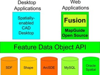
Directions Magazine has just released a Podcast on the FDO API which includes commentary from David Kingsbury, Pete Southwood, and myself on how FDO, which is open source and available on the FDO OSGEO Web […]
Some sessions that some of my colleagues and I are involved with at GeoWeb Wednesday are Wed 10:45 National Critical Infrastructure Data Models: Implications for Local Government and UtilitiesPanel: Paula Rojas, CGDI Content Coordinator, GeoConnections […]
Neal Niemiec and I will be giving an afternoon hands-on lab today on open source geospatial at OSCON in Portland. The last time we looked 60 people had signed up for this hands-on lab. What […]
On the first day of GeoWeb 2008, Neal Niemiec gave a hands-on afternoon lab on integrating CAD, GIS and BIM technologies on an open source platform, MapGuide Open Source and FDO. Neal included an introduction […]
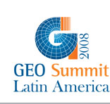
I have attended GeoBrazil almost every year since 2003. This year it was part of Geo Summit Latin America 2008 , together with three other geospatial related conference Geo Oleo e Gas, Geo Cidades, and […]
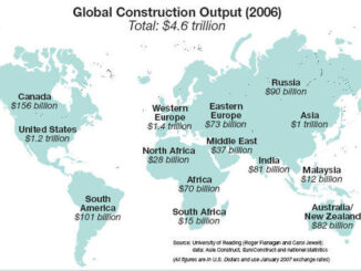
One of the readers of this blog Mike Smith asked about the source of the total value of world construction that I’ve been using. That peaked my interest and I’ve done a further bit of […]
GeoWeb 2008 will be taking place in Vancouver July 21-25. This is always a worthwhile event, and this year looks better than ever. I would recommend that you go if you can. Some of the […]
For francophones Gwenael Bachelot has just published an interesting article on CAD/GIS integration CAO et SIG : l’avantage de n’avoir qu’une version de la réalité du terrain in the French edition of Directions Magazine. If […]
For all of you who are interested in running AutoCAD Map3D on Citrix, there will be a live webinar June 25, 2008 10:00am PT / 1:00pm ET. This webinar is specifically targeted on utility and […]
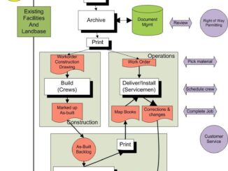
One of the things that has struck me after a number of years travelling and visiting utilities and telecoms world wide is the similarity of the process used to design and manage utility and telecommunications […]
The MapGuide Open Source Project Team are pleased to announce the release of MapGuide Open Source 2.0.1. This release includes support for FDO 3.3.1 and bug fixes since 2.0.0. For the complete list please see […]
GeoTec 2008 will be happening in Ottawa Jun 2-5. This is always an interesting event with very forward looking sessions. A few highlights involving some of my colleagues include Mon June 2 9-12 Doug Eberhard […]
June 25-27 the Autodesk Developer Network (ADN) will be hosting a Geospatial Devcamp at the Embassy Suites in San Rafael, California. If you are interested in learning how to develop solutions with MapGuide, FDO, AutoCAD […]