• facebook
  • Twitter
  • Linkedin
  • Youtube
  • Linkedin Group
  • Post a Job
  • Post an Ad
  • Post an Event
  • Post a Directory Listing
  • Post a Press Release
  • Media Kit
  • My Account
  • Login
GoGeomatics
  • MAGAZINE
    • BIM & GIS
    • Community
    • Conference news
    • Earth Observation
    • Education & Careers
    • GEOAI
    • Announcements
    • Reality Capture & Lidar
    • Science
    • Technology
    • Between the Poles
  • Directories
    • ASSOCIATION
    • INDUSTRY
    • EDUCATION
    • Open Data
  • EVENTS
    • GeoIgnite Events
    • Events Calendar
    • GoGeomatics Meetups
  • Services
    • Advertising
    • Marketing
    • Post a Job
    • Post an Ad
    • Post an Event
    • Post a Press Release
    • Post a Directory Listing
    • Media Kit
    • Web Design
  • Find a Job
  • Volunteer
    • Start a GoGeomatics Group
    • Editors & Writers Group
  • About Us
    • About Us
    • Contact Us
    • Frequently Asked Questions
  • Videos
HomeBetween the Poles – The Geoff Zeiss Archives

Between the Poles – The Geoff Zeiss Archives

Between the Poles – The Geoff Zeiss Archives

Survey finds inaccurate underground asset location data biggest cause of damage risk

23 December 2020 Geoff Zeiss

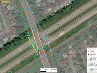
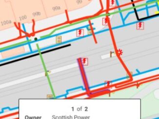
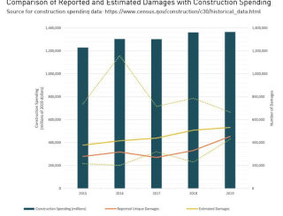
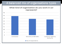
Number of respondents: Contractors, statutory excavators, and roads authorities A survey of stakeholders in the construction industry has reported that respondents identified unreliable (inaccurate, incomplete) records as the biggest source of risk of damage to […]

Between the Poles – The Geoff Zeiss Archives

A revolutionary source of underground utility location data for SUE surveys

15 December 2020 Geoff Zeiss

Return on investment (ROI) studies of subsurface engineering utility engineering (SUE) surveys applied to highway construction projects conducted since the late 1990s have consistently revealed a large return-on-investment from conducting SUE surveys as part of […]

Between the Poles – The Geoff Zeiss Archives

Can all underground utilities be integrated into a single infrastructure map ?

14 December 2020 Geoff Zeiss

The vision of a single map showing all underground utilities and communications infrastructure is shared by many who are involved in planning, engineering and construction and those developing digital twins.  But in many jurisdictions there […]

3D data

Should underground infrastructure location data be included in digital twins ?

7 December 2020 Geoff Zeiss

There are fundamental differences between above- and below-ground data which may limit the usefulness of underground data in digital twins.  For location data about the underground there are often data quality issues, legal restrictions on […]

Between the Poles – The Geoff Zeiss Archives

Estonia developing a national digital twin to increase construction productivity

3 December 2020 Geoff Zeiss

Estonia is well known as one of the most digital countries in Europe.  At the GEOBIM 2020 conference this morning Christopher-Robin Raitviir, of the Estonian Department of Digital Construction in the Ministry of Economic Affairs […]

Between the Poles – The Geoff Zeiss Archives

Major benefits of accurate location information about underground infrastructure prior to design

23 November 2020 Geoff Zeiss

Blue bars – Construction spending ($millions). Red line – Reported unique damages. Yellow line – Estimated damages. Dotted lines – error bars. Source CGA 2020 DIRT Report The stated objectives of many initiatives focussed on […]

Between the Poles – The Geoff Zeiss Archives

Advances in capturing and sharing location information about underground infrastructure in Europe

19 November 2020 GoGeomatics Canada

I was invited to participate in a meeting of the European Underground Infrastructure Community this morning.  I heard about very important advances in capturing, capturing and sharing location information (maps) about underground infrastructure that are […]

Between the Poles – The Geoff Zeiss Archives

Preventing damage to underground infrastructure in Denmark

23 October 2020 Geoff Zeiss

Underground utilities and other infrastructure are a major cause of highway construction schedule and budget overruns. In addition to construction delays, damage to underground utilities during construction makes every construction project a potential disaster site […]

Posts pagination

« 1 … 11 12 13 … 314 »

Events

Notice
There are no upcoming events.

View All Events

Services

  • Post a Job
  • Post an Ad
  • Post an Event
  • Post a Directory Listing
  • Post a Press Release
  • Media Kit
  • My Account
  • Login

Jobs

Post a Job
  • GIS Technologist II
    Fernie, B.C.
  • GIS I TECHNOLOGIST
    Fernie, B.C.
  • Survey Crew Chief
    Langley, BC
  • Survey Tech
    Kamloops, BC
View All Jobs
  • Directories
    • Associations Directory
    • Industry Directory
    • Education Programs
    • Open Data
  • Volunteer
    • Start a GoGeomatics Group
    • Editors & Writers Group
  • About Us
    • GoGeomatics Media Kit
    • Who We Are
    • Contact Us
    • FAQ’s
    • Advertising
    • Marketing
  • Subscribe
GoGeomatics
GoGeomatics is the largest and most popular communications hub promoting the Canadian geospatial community. The business was incorporated in 2011. GoGeomatics hosts over 100 fun, free, location technology networking events each year in cities across Canada.

© 2026 GoGeomatics

  • facebook
  • Twitter
  • Linkedin
  • Youtube
  • Linkedin Group