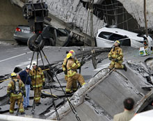
To give you an example of what can happen with aging infrastructure, on September 30, 2006 an overpass in Laval, Quebec, Canada collapsed killing 5 people. As you might expect this caused near panic in […]
The OSGEO has announced that MapGuide Open Source 1.2 has been released. You can check the OSGEO Announcement for what’s new in MapGuide Open Source 1.2.
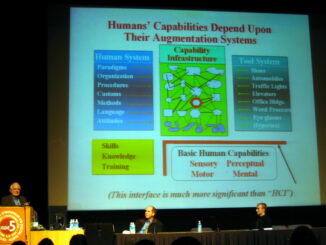
There are some very serious challenges facing the construction industry that are motivating new approaches to how we design, build, operate, and maintain buildings and infrastructure. While these new technologies are designed to address challenges […]
There are some pretty interesting things on the Autodesk Labs site that are worth checking out. One thing you may find pretty interesting is Freewheel , which allows you to look at 2D and 3D […]
FOSS4G , which is the annual world-wide free and open source geospatial conference, will be occurring Sep 24 to 27 in Victoria BC Canada. Preliminary indications Geotips report that 450 have already registered, and based […]
Niel Niemiec, Paul Spencer, Dave McIlhagga and I delivered a workshop at Geoweb 2007 in Vancouver that introduced participants to developing Web 2.0 applications on an open source platform including MapGuide Open Source, FDO, and […]
Recently I had the opportunity to visit a very interesting company, iMapData, which is now part of ChoicePoint. These folks started out in the late 90’s doing market studies for blue chip commercial organizations. After […]
I had the opportunity to drop by the NXTcomm conference in Chicago on my way to Washington from San Francisco and it was worth it. I have not seen so much energy around telecom since […]
Doug Engelbart gave one of the keynotes at ISDE5. Doug is originally from Oregon but has been in the Bay area most of his working life. In 2000 he was awarded the National Medal of […]
I have been able to attend and present at the 5th International Symposium on Digital Earth at the University of California Berkeley. For those of you not familiar with Digital Earth, it’s a concept, popularized […]
At GeoTec 2007 in Calgary Alberta GeoTec Media announced the winners of its inaugural Geospatial Leadership Awards . This is a new awards program that was “created to identify and recognize individuals and organizations for […]
In the US digital spatial data collected at taxpayer expense is available from the Federal government at no cost. The best known example is the TIGER/Line (R) files, which comprise a digital database of geographic […]
I just spent two days at a remarkable conference in Toronto. The conference was a joint effort of the Canadian Institute of Geomatics and the ISPRS. It was very well attended, primarily by Canadians, but […]
I have been in Hobart , Tasmania this week at the Spatial Sciences Institute Biennial International Conference. This is the second time I have been to a SSI conference and I have found these events […]
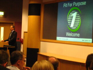
The 1Spatial Conference took place this year at the Ordnance survey in Southampton. It was an outstanding conference in many ways, one of which was the weather, which was brilliant. I must admit that on […]
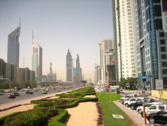
I just spent a couple of days at Map Middle East 2007 in Dubai. The theme of this year’s conference was Geospatial Convergence: The Next step. Dubai is a perfect place for this theme. I […]
At GITA 2007 in San Antonio two weeks ago, a four hour pre-conference workshop entitled Mapping Applications on the Web: Evolution or Revolution? was organized by Charlie Savage of MapBuzz. The titles of the individual […]
The OSGeo and the MapGuide Open Source project have just announced that MapGuide Open Source has graduated from the incubation process and is now a full fledged OSGeo project OSGeo Announcement . Graduating incubation basically […]
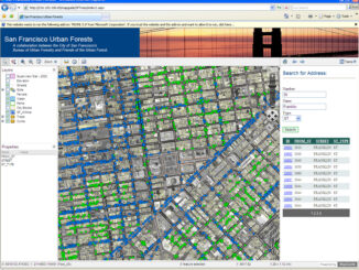
By Charlie Crocker Geoff has been kind enough to lend me his blog to share an exciting project Autodesk has been working with the City of San Francisco and the Friends of the Urban Forest […]
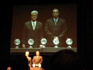
This afternoon in San Antonio, Paulo S. Furukawa, Director of Network Access, and Marcos Faria, who was the Network Records manager responsible for the Sagre Constellation project, accepted on behalf of the Sagre Constellation team, […]