• facebook
  • Twitter
  • Linkedin
  • Youtube
  • Linkedin Group
  • Post a Job
  • Post an Ad
  • Post an Event
  • Post a Directory Listing
  • Post a Press Release
  • Media Kit
  • My Account
  • Login
GoGeomatics
  • MAGAZINE
    • BIM & GIS
    • Community
    • Conference news
    • Earth Observation
    • Education & Careers
    • GEOAI
    • Announcements
    • Reality Capture & Lidar
    • Science
    • Technology
    • Between the Poles
  • Directories
    • ASSOCIATION
    • INDUSTRY
    • EDUCATION
    • Open Data
  • EVENTS
    • GeoIgnite Events
    • Events Calendar
    • GoGeomatics Meetups
  • Services
    • Advertising
    • Marketing
    • Post a Job
    • Post an Ad
    • Post an Event
    • Post a Press Release
    • Post a Directory Listing
    • Media Kit
    • Web Design
  • Find a Job
  • Volunteer
    • Start a GoGeomatics Group
    • Editors & Writers Group
  • About Us
    • About Us
    • Contact Us
    • Frequently Asked Questions
  • Videos
HomeBetween the Poles – The Geoff Zeiss Archives

Between the Poles – The Geoff Zeiss Archives

Between the Poles – The Geoff Zeiss Archives

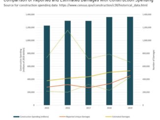
Latest statistics reveal little progress in reducing damage to underground infrastructure during construction

16 October 2020 Geoff Zeiss

The primary objective of interventions such as one-call centres, pipeline safety and other regulations, and national programs such as ROADIC in Japan is the reduction of damage to underground infrastructure during excavation. Collecting reliable statistics […]

Between the Poles – The Geoff Zeiss Archives

Ofwat mandates game changer by making water utilities responsible for 3rd party damage to infrastructure

6 October 2020 Geoff Zeiss

The recent PR19 comprehensive price review of the water industry by Ofwat, the economic regulator of the water sector in England and Wales has targeted an aggressive “reducing leakage by 15% within base costs” and […]

3D data

Advanced geophysical remote sensing rapidly captures high resolution 3D data about subsurface geology

22 September 2020 Geoff Zeiss

Uncertain knowledge about what lies under the surface is a major cause of delays and budget overruns on construction projects.  It is well known that not knowing the location of utilities and other infrastructure is […]

Aging infrastructure

Growing gap in electric power infrastructure investment in the U.S. will decrease reliability and resilience of the grid

8 September 2020 Geoff Zeiss

Last week the American Society of Civil Engineers (ASCE) released a new report in the Failure to Act series “Electric Infrastructure Investment Gaps in a Rapidly Changing Environment” that estimates the investment gap through 2039 […]

Between the Poles – The Geoff Zeiss Archives

Satellite able to measure methane emissions from individual facilities launched

3 September 2020 Geoff Zeiss

Last night, September 2 at 11:51 p.m. EDT at the Arianespace satellite launch base in Kourou, French Guiana (UTC-3) the VV16 mission launched 53 satellites, ranging in weight from 145 kg to 7 kg.  Among […]

Between the Poles – The Geoff Zeiss Archives

Innovative solution efficiently captures accurate underground utility as-builts during construction

18 August 2020 GoGeomatics Canada

Most of underground utility damage during construction is attributable to incomplete, inaccurate and out of date records and network documentation. This data is the result of an inefficient, error-prone, and paper-based information flow from engineering, […]

3D data

Study shows augmented reality improves productivity of underground utility locators

4 August 2020 Geoff Zeiss

Mixed reality applications for visualizing underground utilities in 3D have been available from many companies for years, but have not been widely used. There are signs this is changing. For example, vGIS is an augmented […]

Between the Poles – The Geoff Zeiss Archives

Nanosatellites and drones represent a paradigm shift in measurement of methane emissions

30 July 2020 Geoff Zeiss

Annual emissions of methane (CH4) have risen by almost 10% in the past two decades. The primary sources of methane are the oil and gas industry and agriculture, in large part from livestock.  Methane emissions […]

Posts pagination

« 1 … 12 13 14 … 314 »

Events

Notice
There are no upcoming events.

View All Events

Services

  • Post a Job
  • Post an Ad
  • Post an Event
  • Post a Directory Listing
  • Post a Press Release
  • Media Kit
  • My Account
  • Login

Jobs

Post a Job
  • GIS Technologist II
    Fernie, B.C.
  • GIS I TECHNOLOGIST
    Fernie, B.C.
  • Survey Crew Chief
    Langley, BC
  • Survey Tech
    Kamloops, BC
View All Jobs
  • Directories
    • Associations Directory
    • Industry Directory
    • Education Programs
    • Open Data
  • Volunteer
    • Start a GoGeomatics Group
    • Editors & Writers Group
  • About Us
    • GoGeomatics Media Kit
    • Who We Are
    • Contact Us
    • FAQ’s
    • Advertising
    • Marketing
  • Subscribe
GoGeomatics
GoGeomatics is the largest and most popular communications hub promoting the Canadian geospatial community. The business was incorporated in 2011. GoGeomatics hosts over 100 fun, free, location technology networking events each year in cities across Canada.

© 2026 GoGeomatics

  • facebook
  • Twitter
  • Linkedin
  • Youtube
  • Linkedin Group