• facebook
  • Twitter
  • Linkedin
  • Youtube
  • Linkedin Group
  • Post a Job
  • Post an Ad
  • Post an Event
  • Post a Directory Listing
  • Post a Press Release
  • Media Kit
  • My Account
  • Login
GoGeomatics
  • MAGAZINE
    • BIM & GIS
    • Community
    • Conference news
    • Earth Observation
    • Education & Careers
    • GEOAI
    • Announcements
    • Reality Capture & Lidar
    • Science
    • Technology
    • Between the Poles
  • Directories
    • ASSOCIATION
    • INDUSTRY
    • EDUCATION
    • Open Data
  • EVENTS
    • GeoIgnite Events
    • Events Calendar
    • GoGeomatics Meetups
  • Services
    • Advertising
    • Marketing
    • Post a Job
    • Post an Ad
    • Post an Event
    • Post a Press Release
    • Post a Directory Listing
    • Media Kit
    • Web Design
  • Find a Job
  • Volunteer
    • Start a GoGeomatics Group
    • Editors & Writers Group
  • About Us
    • About Us
    • Contact Us
    • Frequently Asked Questions
  • Videos
HomeBetween the Poles – The Geoff Zeiss Archives

Between the Poles – The Geoff Zeiss Archives

Between the Poles – The Geoff Zeiss Archives

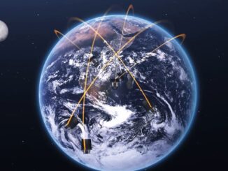
New satellite constellation will capture 30 cm imagery with up to 15 revisits per day

23 July 2020 Geoff Zeiss

I remember back in August 2014, when the first images from WorldView-3 were being downloaded. WorldView-3 was the first one-foot-resolution commercial satellite. It operated at an altitude of 617 km, flew in a sun synchronous […]

3D data

Innovative technology uses AM radio waves to detect underground infrastructure

21 July 2020 Geoff Zeiss

In the last few years there have been important advances in technology for detecting underground infrastructure including capturing ground penetrating radar (GPR) scans at highway speeds, combined GPR and LiDAR scanning for simultaneous above and […]

Between the Poles – The Geoff Zeiss Archives

Geospatial+BIM are a major contributor transforming construction

17 July 2020 Geoff Zeiss

Geospatial and BIM have been identified as key technologies in the digital transformation of the global construction sector which has been underperforming for decades.  A recent report estimates the size of the contribution of geospatial+BIM […]

Between the Poles – The Geoff Zeiss Archives

New standard for capturing information about underground utilities exposed during construction

8 July 2020 Geoff Zeiss

In Germany a new standard for documenting and exchanging information about underground infrastructure exposed during construction has been developed. Referred to as DIN SPEC 91419 it provides a standardized way to capture and share a […]

3D data

Above and underground infrastructure comprise Rotterdam’s open digital twin

6 July 2020 Geoff Zeiss

The City of Rotterdam is developing a digital twin of the city.  3D vector and image data of the above- and underground infrastructure, zoning regulations and city by-laws, data streams from real-time sensors, applications and […]

Between the Poles – The Geoff Zeiss Archives

Using satellite imagery to prioritize vegetation management for utilities

25 June 2020 Geoff Zeiss

A recent startup LiveEO is focusing on the digitalization of energy and transportation network assets using satellite imagery. LiveEO uses current multi-band imagery including radar and hyperspectral data at various resolutions from earth observation satellites […]

Between the Poles – The Geoff Zeiss Archives

Scotland’s system for sharing location information about underground infrastructure to be mandatory

23 June 2020 Geoff Zeiss

Scotland is one of the leading jurisdictions in developing a nation-wide collaborative system for sharing information about the location of underground infrastructure among stakeholders involved in road construction including roads authorities, utility and telecom network […]

Between the Poles – The Geoff Zeiss Archives

Collaboration key to success of U.K. National Underground Asset Register pilots

22 June 2020 Geoff Zeiss

At a Digital Leaders Virtual event Heath Pritchard, Maria Teneke, Holger Kessler and Neil Brammall of the National Underground Asset Register (NUAR) project reported on the progress to date of one of the Geospatial Commission’s […]

Posts pagination

« 1 … 13 14 15 … 314 »

Events

Notice
There are no upcoming events.

View All Events

Services

  • Post a Job
  • Post an Ad
  • Post an Event
  • Post a Directory Listing
  • Post a Press Release
  • Media Kit
  • My Account
  • Login

Jobs

Post a Job
  • GIS Technologist II
    Fernie, B.C.
  • GIS I TECHNOLOGIST
    Fernie, B.C.
  • Survey Crew Chief
    Langley, BC
  • Survey Tech
    Kamloops, BC
View All Jobs
  • Directories
    • Associations Directory
    • Industry Directory
    • Education Programs
    • Open Data
  • Volunteer
    • Start a GoGeomatics Group
    • Editors & Writers Group
  • About Us
    • GoGeomatics Media Kit
    • Who We Are
    • Contact Us
    • FAQ’s
    • Advertising
    • Marketing
  • Subscribe
GoGeomatics
GoGeomatics is the largest and most popular communications hub promoting the Canadian geospatial community. The business was incorporated in 2011. GoGeomatics hosts over 100 fun, free, location technology networking events each year in cities across Canada.

© 2026 GoGeomatics

  • facebook
  • Twitter
  • Linkedin
  • Youtube
  • Linkedin Group