• facebook
  • Twitter
  • Linkedin
  • Youtube
  • Linkedin Group
  • Post a Job
  • Post an Ad
  • Post an Event
  • Post a Directory Listing
  • Post a Press Release
  • Media Kit
  • My Account
  • Login
GoGeomatics
  • MAGAZINE
    • BIM & GIS
    • Community
    • Conference news
    • Earth Observation
    • Education & Careers
    • GEOAI
    • Announcements
    • Reality Capture & Lidar
    • Science
    • Technology
    • Between the Poles
  • Directories
    • ASSOCIATION
    • INDUSTRY
    • EDUCATION
    • Open Data
  • EVENTS
    • GeoIgnite Events
    • Events Calendar
    • GoGeomatics Meetups
  • Services
    • Advertising
    • Marketing
    • Post a Job
    • Post an Ad
    • Post an Event
    • Post a Press Release
    • Post a Directory Listing
    • Media Kit
    • Web Design
  • Find a Job
  • Volunteer
    • Start a GoGeomatics Group
    • Editors & Writers Group
  • About Us
    • About Us
    • Contact Us
    • Frequently Asked Questions
  • Videos
HomeBetween the Poles – The Geoff Zeiss Archives

Between the Poles – The Geoff Zeiss Archives

Between the Poles – The Geoff Zeiss Archives

Digitally capturing the location of underground utilities detected using electromagnetic techniques

16 June 2020 Geoff Zeiss

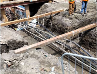
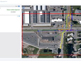
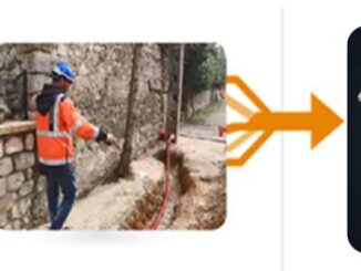
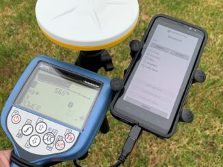
The industry standard for locating underground utilities is a manual process involving the use of an electromagnetic (EM) wand to detect underground cables and pipes.  The detected location is typically recorded by painting or otherwise […]

Between the Poles – The Geoff Zeiss Archives

Survey delineates subsurface utility engineering (SUE) adoption in Canada

15 June 2020 Geoff Zeiss

The Centre for Advancement of Trenchless Technologies(CATT) has just released the report of a survey designed to better understand the current state of subsurface utility engineering (SUE) practices, barriers, and acceptance across Canada.  The most […]

3D data

Using statistical averaging to increase depth of penetration for ground penetrating radar

10 June 2020 Geoff Zeiss

Recently Greg Johnston of Sensors and Software gave a very informative webinar on the factors that limit the depth to which ground penetrating radar (GPR) is effective in detecting objects.  Greg showed how statistical averaging […]

3D data

White paper on reducing damage to underground utilities during construction

2 June 2020 Geoff Zeiss

It is estimated that unreliable location information about underground infrastructure represents a $50 billion drag on the U.S. economy. Comparing the United States and Japan reveals a startling difference in the annual incidents of underground […]

Between the Poles – The Geoff Zeiss Archives

Australian water utility provides open access to water and wastewater network location data

19 May 2020 Geoff Zeiss

Open data has become a goal for many governments, but is relatively rare among utility and telecom network operators and owners.  In Australia several water and wastewater network operators have made the location of their […]

3D data

Montana mandates the submission of accurate electronic as-builts by utility owners

13 May 2020 Geoff Zeiss

Montana has recently revised its statutes governing the installation of utilities on state highway right-of-ways. The revised statutes require Administrative Rules regarding utility occupancy on state highway right-of-ways. The updated Administrative Rules mandate that as […]

3D data

Centimetre-accurate as-builts efficiently captured with a smartphone

7 May 2020 Geoff Zeiss

Without accurate maps of underground infrastructure, every construction project has the potential to become a disaster site. Incidents of underground utility damage are more frequent than many people realize. In the U.S. there are between […]

Analytics

Automated drone systems improve power line inspections and reduce costs

5 May 2020 Geoff Zeiss

Transmission line inspections are mandatory in North America. Traditionally helicopters are used for these inspections, but with helicopters the risk of accidents is significant and helicopters are costly to maintain and operate.  Drone inspections dramatically […]

Posts pagination

« 1 … 14 15 16 … 314 »

Events

Notice
There are no upcoming events.

View All Events

Services

  • Post a Job
  • Post an Ad
  • Post an Event
  • Post a Directory Listing
  • Post a Press Release
  • Media Kit
  • My Account
  • Login

Jobs

Post a Job
  • GIS Technologist II
    Fernie, B.C.
  • GIS I TECHNOLOGIST
    Fernie, B.C.
  • Survey Crew Chief
    Langley, BC
  • Survey Tech
    Kamloops, BC
View All Jobs
  • Directories
    • Associations Directory
    • Industry Directory
    • Education Programs
    • Open Data
  • Volunteer
    • Start a GoGeomatics Group
    • Editors & Writers Group
  • About Us
    • GoGeomatics Media Kit
    • Who We Are
    • Contact Us
    • FAQ’s
    • Advertising
    • Marketing
  • Subscribe
GoGeomatics
GoGeomatics is the largest and most popular communications hub promoting the Canadian geospatial community. The business was incorporated in 2011. GoGeomatics hosts over 100 fun, free, location technology networking events each year in cities across Canada.

© 2026 GoGeomatics

  • facebook
  • Twitter
  • Linkedin
  • Youtube
  • Linkedin Group