• facebook
  • Twitter
  • Linkedin
  • Youtube
  • Linkedin Group
  • Post a Job
  • Post an Ad
  • Post an Event
  • Post a Directory Listing
  • Post a Press Release
  • Media Kit
  • My Account
  • Login
GoGeomatics
  • MAGAZINE
    • BIM & GIS
    • Community
    • Conference news
    • Earth Observation
    • Education & Careers
    • GEOAI
    • Announcements
    • Reality Capture & Lidar
    • Science
    • Technology
    • Between the Poles
  • Directories
    • ASSOCIATION
    • INDUSTRY
    • EDUCATION
    • Open Data
  • EVENTS
    • GeoIgnite Events
    • Events Calendar
    • GoGeomatics Meetups
  • Services
    • Advertising
    • Marketing
    • Post a Job
    • Post an Ad
    • Post an Event
    • Post a Press Release
    • Post a Directory Listing
    • Media Kit
    • Web Design
  • Find a Job
  • Volunteer
    • Start a GoGeomatics Group
    • Editors & Writers Group
  • About Us
    • About Us
    • Contact Us
    • Frequently Asked Questions
  • Videos
HomeBetween the Poles – The Geoff Zeiss Archives

Between the Poles – The Geoff Zeiss Archives

No Picture
Between the Poles – The Geoff Zeiss Archives

Large ROI from subsurface utility engineering (SUE) for highway construction projects

16 March 2020 Geoff Zeiss

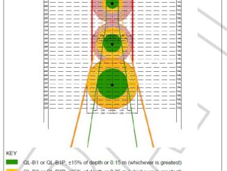
Return on investment (ROI) studies of subsurface engineering utility engineering (SUE) surveys applied to highway construction projects conducted since the late 1990s have consistently revealed a large return-on-investment from conducting SUE surveys as part of […]

No Picture
Between the Poles – The Geoff Zeiss Archives

ROI of $11.39 for every $1 spent on subsurface utility engineering on highway construction projects

10 March 2020 Geoff Zeiss

A definitive study of twenty-two projects utilizing subsurface utility engineering (SUE) and eight non-SUE projects from Pennsylvania Department of Transportation (PennDOT) districts has revealed that $11.39 can be saved for every $1 spent on SUE.  […]

3D data

Revision to PAS 128 standard for locating underground utilities available for public comment

3 March 2020 Geoff Zeiss

A revision to the PAS 128 2014 standard for locating underground utilities is available for public comment through March 16. PAS 128 defines a hierarchy of detection methods for detecting underground utilities in terms and […]

No Picture
3D data

New ASCE standard guideline for recording and exchanging utility infrastructure data is imminent

2 March 2020 Geoff Zeiss

The release of the new ASCE Standard Guideline for Recording and Exchanging Utility Infrastructure Data (also referred to as the utility as-built standard) developed under the auspices of the American Society of Civil Engineers (ASCE’s) […]

Between the Poles – The Geoff Zeiss Archives

Mapping gas flowline and gathering system infrastructure mandatory in Colorado

26 February 2020 Geoff Zeiss

There are nearly a million natural gas and oil wells in the United States, most of which have used fracking to release natural gas and tight oil from underground geological strata.  To gather and collect […]

Between the Poles – The Geoff Zeiss Archives

Damage to underground infrastructure during construction increasing in Ontario

24 February 2020 Geoff Zeiss

Statistics on incidents of underground utility damage from the Ontario Regional Common Ground Alliance (ORCGA) 2018 DIRT report reveals a trend since 2014 of increasing utility damage suggesting that new measures are required to drive […]

Access to Spatial Data

Federal initiatives in Canada to improve subsurface locating to reduce damage during construction

18 February 2020 Geoff Zeiss

A remarkable initiative within the Federal government in Canada to improve mapping of Federally regulated underground infrastructure and infrastructure on Federal lands was presented at the Ontario Regional Common Ground Alliance (ORCGA) 2020 Symposium in […]

Between the Poles – The Geoff Zeiss Archives

Comprehensive checklist of direct and indirect costs of damage to underground infrastructure

17 February 2020 Geoff Zeiss

I have blogged previously about research at the University of Birmingham in the U.K. that found that the indirect and social cost of underground utility damage was 29 X the direct cost.  At the Ontario […]

Posts pagination

« 1 … 16 17 18 … 314 »

Events

Notice
There are no upcoming events.

View All Events

Services

  • Post a Job
  • Post an Ad
  • Post an Event
  • Post a Directory Listing
  • Post a Press Release
  • Media Kit
  • My Account
  • Login

Jobs

Post a Job
  • GIS Technologist II
    Fernie, B.C.
  • GIS I TECHNOLOGIST
    Fernie, B.C.
  • Survey Crew Chief
    Langley, BC
  • Survey Tech
    Kamloops, BC
View All Jobs
  • Directories
    • Associations Directory
    • Industry Directory
    • Education Programs
    • Open Data
  • Volunteer
    • Start a GoGeomatics Group
    • Editors & Writers Group
  • About Us
    • GoGeomatics Media Kit
    • Who We Are
    • Contact Us
    • FAQ’s
    • Advertising
    • Marketing
  • Subscribe
GoGeomatics
GoGeomatics is the largest and most popular communications hub promoting the Canadian geospatial community. The business was incorporated in 2011. GoGeomatics hosts over 100 fun, free, location technology networking events each year in cities across Canada.

© 2026 GoGeomatics

  • facebook
  • Twitter
  • Linkedin
  • Youtube
  • Linkedin Group