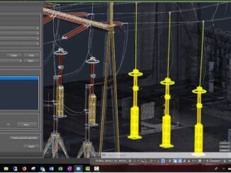
• facebook
  • Twitter
  • Linkedin
  • Youtube
  • Linkedin Group
  • Post a Job
  • Post an Ad
  • Post an Event
  • Post a Directory Listing
  • Post a Press Release
  • Media Kit
  • My Account
  • Login
GoGeomatics
  • MAGAZINE
    • BIM & GIS
    • Community
    • Conference news
    • Earth Observation
    • Education & Careers
    • GEOAI
    • Announcements
    • Reality Capture & Lidar
    • Science
    • Technology
    • Between the Poles
  • Directories
    • ASSOCIATION
    • INDUSTRY
    • EDUCATION
    • Open Data
  • EVENTS
    • GeoIgnite Events
    • Events Calendar
    • GoGeomatics Meetups
  • Services
    • Advertising
    • Marketing
    • Post a Job
    • Post an Ad
    • Post an Event
    • Post a Press Release
    • Post a Directory Listing
    • Media Kit
    • Web Design
  • Find a Job
  • Volunteer
    • Start a GoGeomatics Group
    • Editors & Writers Group
  • About Us
    • About Us
    • Contact Us
    • Frequently Asked Questions
  • Videos
HomeBetween the Poles – The Geoff Zeiss Archives

Between the Poles – The Geoff Zeiss Archives

3D data

Automating scan-to-BIM for brownfield substations

6 February 2020 Geoff Zeiss

With about 55,000 substations in the U.S. and the average age of the transformers in these substations over 40 years old, many substations are going to be refurbished, retrofitted, extended or upgraded. Utilities are opting […]

Between the Poles – The Geoff Zeiss Archives

UK pilots demonstrate secure platform for sharing information about underground utility networks

16 January 2020 Geoff Zeiss

In the 2017 autumn budget the Chancellor of the Exchequer announced an important initiative to increase the value of the contribution of spatial data to the UK economy. The Geospatial Commission was created in the […]

No Picture
Between the Poles – The Geoff Zeiss Archives

Remarkably low incidence of underground utility damage in Japan

20 December 2019 Geoff Zeiss

In the U.S. in 2017 there were 316,422 incidents of damage to underground infrastructure reported to the Common Ground Alliance in 2017.  In the Netherlands in 2018 there were 41,169 incidents.  Remarkably the number I […]

Asset management

Elements for improving underground utility mapping to reduce risk of damage during construction

16 December 2019 Geoff Zeiss

Without accurate maps of underground infrastructure, every construction project has the potential to become a disaster site. Unlike the aviation industry where reliable data is collected and is accessible to investigators to prevent disasters from […]

3D data

Inertial mapping of underground pipe networks

10 December 2019 Geoff Zeiss

Currently best practices for recording the location of new underground infrastructure is to survey it after installation and before covering the trench. Appropriate survey tools are total stations, RTK, and LiDAR.  However, trenchless technology is […]

Between the Poles – The Geoff Zeiss Archives

Locate issues are a major cause of underground utility damage/strikes in U.S. and U.K.

9 December 2019 Geoff Zeiss

In the U.S. and the U.K. statistics reveal that about a quarter of underground utility damage and strikes is attributable to locating issues including inaccurate maps, missing data and problems with underground locating equipment. There […]

Between the Poles – The Geoff Zeiss Archives

Map of underground utilities available within one day of a one-call information request

3 December 2019 Geoff Zeiss

On 30 July 2004 at a construction site in Ghislenghien, Belgium a one metre diameter natural gas pipeline ruptured resulting in 24 fatalities, including five fire-fighters, a police officer and five employees, plus 132 injured […]

3D data

Burgeoning market for shareable subsurface geotechnical information

25 November 2019 Geoff Zeiss

Unforeseen ground conditions are a major cause of delays in construction projects.  This year, at Bentley Systems’ Year in Infrastructure Conference, Roger Chandler, Director of Geotechnical Information Management, announced OpenGround, a collection of applications for […]

Posts pagination

« 1 … 17 18 19 … 314 »

Events

Notice
There are no upcoming events.

View All Events

Services

  • Post a Job
  • Post an Ad
  • Post an Event
  • Post a Directory Listing
  • Post a Press Release
  • Media Kit
  • My Account
  • Login

Jobs

Post a Job
  • GIS Technologist II
    Fernie, B.C.
  • GIS I TECHNOLOGIST
    Fernie, B.C.
  • Survey Crew Chief
    Langley, BC
  • Survey Tech
    Kamloops, BC
View All Jobs
  • Directories
    • Associations Directory
    • Industry Directory
    • Education Programs
    • Open Data
  • Volunteer
    • Start a GoGeomatics Group
    • Editors & Writers Group
  • About Us
    • GoGeomatics Media Kit
    • Who We Are
    • Contact Us
    • FAQ’s
    • Advertising
    • Marketing
  • Subscribe
GoGeomatics
GoGeomatics is the largest and most popular communications hub promoting the Canadian geospatial community. The business was incorporated in 2011. GoGeomatics hosts over 100 fun, free, location technology networking events each year in cities across Canada.

© 2026 GoGeomatics

  • facebook
  • Twitter
  • Linkedin
  • Youtube
  • Linkedin Group