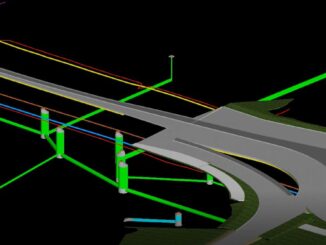
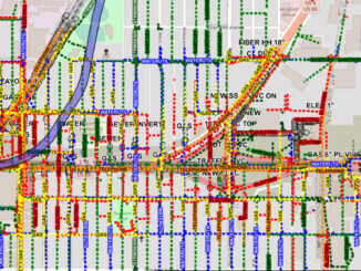
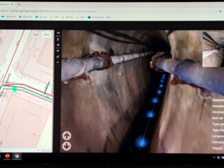
• facebook
  • Twitter
  • Linkedin
  • Youtube
  • Linkedin Group
  • Post a Job
  • Post an Ad
  • Post an Event
  • Post a Directory Listing
  • Post a Press Release
  • Media Kit
  • My Account
  • Login
GoGeomatics
  • MAGAZINE
    • BIM & GIS
    • Community
    • Conference news
    • Earth Observation
    • Education & Careers
    • GEOAI
    • Announcements
    • Reality Capture & Lidar
    • Science
    • Technology
    • Between the Poles
  • Directories
    • ASSOCIATION
    • INDUSTRY
    • EDUCATION
    • Open Data
  • EVENTS
    • GeoIgnite Events
    • Events Calendar
    • GoGeomatics Meetups
  • Services
    • Advertising
    • Marketing
    • Post a Job
    • Post an Ad
    • Post an Event
    • Post a Press Release
    • Post a Directory Listing
    • Media Kit
    • Web Design
  • Find a Job
  • Volunteer
    • Start a GoGeomatics Group
    • Editors & Writers Group
  • About Us
    • About Us
    • Contact Us
    • Frequently Asked Questions
  • Videos
HomeBetween the Poles – The Geoff Zeiss Archives

Between the Poles – The Geoff Zeiss Archives

3D data

Integrating 3D models and GIS for underground asset management

20 November 2019 Geoff Zeiss

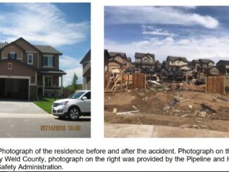
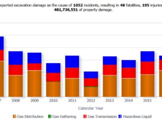
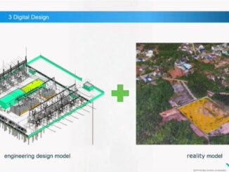
I had the opportunity to attend the 1Spatial Smarter Data Smarter World conference in London.  A presentation by Seb Lessware, CTO of 1Spatial, of Realworld 4D for BIM and facilities management demonstrated an impressive integration […]

Between the Poles – The Geoff Zeiss Archives

Mapping underground utilities required for public civil engineering projects in Colorado

18 November 2019 Geoff Zeiss

Colorado’s statutes for the prevention of damage to underground utilities were assessed by the federal pipeline authority PHMSA in 2014 and found to be below standard in two areas. As a result the Colorado General […]

Between the Poles – The Geoff Zeiss Archives

Excavation damage remains a leading cause of serious pipeline accidents

13 November 2019 Geoff Zeiss

Pipeline incidents (gas distribution, gas transmission, gas gathering and hazardous liquid) resulting from excavation damage 2005-2019 Gas and hazardous pipeline operators are required to report all pipeline incidents to Pipeline and Hazardous Materials Safety Administration […]

3D data

Breakthrough broadens adoption of GPR in 3D mapping of underground utilities

8 November 2019 Geoff Zeiss

Traditional output from a GPR scanner showing hyperbolas reflected from underground utilities The major inhibitor to broader use of ground penetrating radar for detecting the location of underground utilities is the difficulty in interpreting radar […]

3D data

First substation built using full life-cycle BIM construction goes live one month early

5 November 2019 Geoff Zeiss

Hubei Electric Engineering Corporation (HEEC) was this year’s winner of the Bentley Year in Infrastructure Communications and Utilities award.  One of the key objectives of the ground-breaking CNY 120 million (US$16.8 million) Miluo Western 220kV […]

3D data

Mapping underground utilities prior to design helps highway construction project complete on schedule and below budget

1 November 2019 Geoff Zeiss

The winner of the Bentley Year in Infrastructure 2019 Roads and Highways award is a remarkable project by Foth Infrastructure and Environment LLC for a $38.9 million highway revitalization project in Cedar Falls, Iowa. This […]

Between the Poles – The Geoff Zeiss Archives

Ground-breaking initiative by Colorado DOT for capturing and sharing location of underground utilities

29 October 2019 Geoff Zeiss

According to the Federal Highway Administration (FHWA) missing or inaccurate location information about underground utilities is a major source of highway construction project delays and budget overruns.  Some jurisdictions have taken advantage of their legal […]

3D data

New OpenGround product for sharing underground geotechnical data achieves over 500,000 boreholes

28 October 2019 Geoff Zeiss

Unforeseen ground conditions are a major cause of delays in construction projects.  This year at the Year in Infrastructure event Bentley announced OpenGround a collection of applications for collecting, sharing, visualizing, analyzing, and accessing geotechnical […]

Posts pagination

« 1 … 18 19 20 … 314 »

Events

Notice
There are no upcoming events.

View All Events

Services

  • Post a Job
  • Post an Ad
  • Post an Event
  • Post a Directory Listing
  • Post a Press Release
  • Media Kit
  • My Account
  • Login

Jobs

Post a Job
  • GIS Technologist II
    Fernie, B.C.
  • GIS I TECHNOLOGIST
    Fernie, B.C.
  • Survey Crew Chief
    Langley, BC
  • Survey Tech
    Kamloops, BC
View All Jobs
  • Directories
    • Associations Directory
    • Industry Directory
    • Education Programs
    • Open Data
  • Volunteer
    • Start a GoGeomatics Group
    • Editors & Writers Group
  • About Us
    • GoGeomatics Media Kit
    • Who We Are
    • Contact Us
    • FAQ’s
    • Advertising
    • Marketing
  • Subscribe
GoGeomatics
GoGeomatics is the largest and most popular communications hub promoting the Canadian geospatial community. The business was incorporated in 2011. GoGeomatics hosts over 100 fun, free, location technology networking events each year in cities across Canada.

© 2026 GoGeomatics

  • facebook
  • Twitter
  • Linkedin
  • Youtube
  • Linkedin Group