• facebook
  • Twitter
  • Linkedin
  • Youtube
  • Linkedin Group
  • Post a Job
  • Post an Ad
  • Post an Event
  • Post a Directory Listing
  • Post a Press Release
  • Media Kit
  • My Account
  • Login
GoGeomatics
  • MAGAZINE
    • BIM & GIS
    • Community
    • Conference news
    • Earth Observation
    • Education & Careers
    • GEOAI
    • Announcements
    • Reality Capture & Lidar
    • Science
    • Technology
    • Between the Poles
  • Directories
    • ASSOCIATION
    • INDUSTRY
    • EDUCATION
    • Open Data
  • EVENTS
    • GeoIgnite Events
    • Events Calendar
    • GoGeomatics Meetups
  • Services
    • Advertising
    • Marketing
    • Post a Job
    • Post an Ad
    • Post an Event
    • Post a Press Release
    • Post a Directory Listing
    • Media Kit
    • Web Design
  • Find a Job
  • Volunteer
    • Start a GoGeomatics Group
    • Editors & Writers Group
  • About Us
    • About Us
    • Contact Us
    • Frequently Asked Questions
  • Videos
HomeBetween the Poles – The Geoff Zeiss Archives

Between the Poles – The Geoff Zeiss Archives

Total articles: 2505

Between the Poles – The Geoff Zeiss Archives

Developing a subsurface digital twin for Canada

9 May 2022 Geoff Zeiss

The Canadian Underground Infrastructure Register initiative Underground infrastructure provides the essential services that fuel our economy. During construction excavators often damage elements of this infrastructure because the location of underground cables, pipes and ducts is […]

Read more

Access to Spatial Data

Visualizing underground infrastructure for multiple utilities on a single map

3 May 2022 Geoff Zeiss

The National Underground Asset Register (NUAR) is intended to be a comprehensive digital map of all underground pipes and cables owned and operated by 650 asset owners in England, Wales and Northern Ireland. When deployed […]

Read more

Between the Poles – The Geoff Zeiss Archives

California legislation mandates reporting underground utility damage by excavators

27 April 2022 Geoff Zeiss

In 2016 in the first of several far reaching regulations the California legislature passed SB 661 that created the California Underground Facilities Safe Excavation Board. The primary activities of the board were to develop standards […]

Read more

Between the Poles – The Geoff Zeiss Archives

AGC one call survey: lack of accurate utility locating by network owners weakest element

14 April 2022 Geoff Zeiss

Recently the Associated General Contractors of America (AGC) conducted a survey of one call (811) underground utility safety and damage prevention processes among contractors in various construction sectors including heavy water/wastewater, highway/bridge, telecom, gas transmission […]

Read more

No Picture
Between the Poles – The Geoff Zeiss Archives

The National Underground Asset Register in the UK is holding a public consultation

11 April 2022 Geoff Zeiss

The Geospatial Commission is building a digital service for sharing data on the location of underground infrastructure – the National Underground Asset Register (NUAR). It is planned that NUAR will provide a consistent, digital map […]

Read more

Between the Poles – The Geoff Zeiss Archives

Is a national map of underground infrastructure achievable ?

4 April 2022 Geoff Zeiss

According to a recent report from the Next Practices Initiative of the Common Ground Alliance the damage prevention industry has reached an inflection point. For more than half a decade, the rate of damage to […]

Read more

Augmented reality

Reducing damage to underground utilities: the French DT DICT system

29 March 2022 Geoff Zeiss

In France a national system for reducing damage to underground utilities during construction was initiated in 2013.  The key features of the system are the requirement to notify utilities with the details of a proposed […]

Read more

No Picture
Between the Poles – The Geoff Zeiss Archives

Subsurface Utility Mapping Strategy Forum – Workshops March 24/25

22 March 2022 Geoff Zeiss

The Subsurface Utility Mapping Strategy Forum (SUMSF) workshops are free virtual sessions for individuals who want to delve deeper into technologies for locating and mapping underground infrastructure. The priority use cases are reducing damage to […]

Read more

Between the Poles – The Geoff Zeiss Archives

Effectiveness of different underground utility information policies in reducing utility damage during construction

21 March 2022 Geoff Zeiss

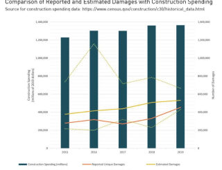
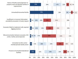
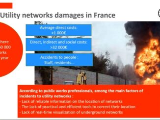
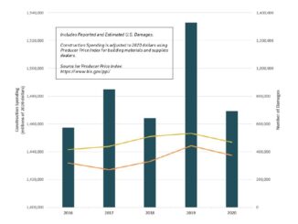
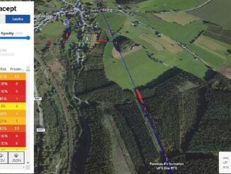
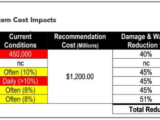
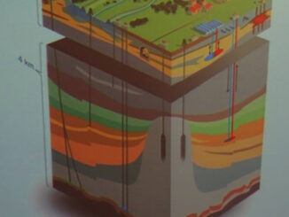
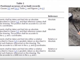
The primary objective of interventions relating to underground infrastructure is reducing damage to underground infrastructure during excavation. Different jurisdictions have implemented different schemes for reducing damage to underground infrastructure during construction. It is a well-known […]

Read more

Between the Poles – The Geoff Zeiss Archives

Subsurface Utility Mapping Strategy Forum – Speakers for Day 2 March 23

16 March 2022 Geoff Zeiss

The Subsurface Utility Mapping Strategy Forum (SUMSF), Mar 22-23, 2022 is a free virtual conference that brings together individuals and organizations to share information about and contribute to improving the mapping of underground infrastructure. The […]

Read more

No Picture
Between the Poles – The Geoff Zeiss Archives

Subsurface Utility Mapping Strategy Forum – Speakers for Day 1 March 22

10 March 2022 Geoff Zeiss

The Subsurface Utility Mapping Strategy Forum (SUMSF), Mar 22-23, 2022 is a free virtual conference that brings together individuals and organizations to share information about and contribute to improving the mapping of underground infrastructure. The […]

Read more

3D data

Subsurface digital twins: How Singapore plans to address data quality and accessibility challenges

9 February 2022 Geoff Zeiss

TThe recently published Digital Underground: Imagining a digitally enabled future is full of insights derived from a four year effort by the Singapore Land Authority in developing a road map for a coherent national mapping […]

Read more

3D data

Challenges of subsurface digital twins

10 January 2022 Geoff Zeiss

The subsurface is composed up man made infrastructure; utility, transportation, and other infrastructure and the natural environment comprised of geology and geotechnical properties of the subsurface. A comprehensive subsurface digital twin requires a digital twin […]

Read more

3D data

CSA S-250 one of the first national “as-installed” standards for underground infrastructure

22 December 2021 Geoff Zeiss

In Canada the goal of the Canadian Standards Association (CSA) S250 Standard, first published in 2011 and revised in 2020, is to specify mapping requirements for the recording and depiction of newly installed underground utility […]

Read more

3D data

New digital “as-installed” standard for underground and above-ground utility infrastructure

16 December 2021 Geoff Zeiss

Since 2002 there has been a standard, ASCE 38, for investigating and documenting existing underground utility infrastructure.  Now in the US a new standard ASCE 75 is imminent that will define a standard way to […]

Read more

Augmented reality

Keeping utility GISs up to date using automated real-time reality capture

10 December 2021 Geoff Zeiss

Maintaining accurate, up-to-date, comprehensive data about assets, above ground and below ground, has been a challenge for utility and communications firms for decades. Now new technologies including machine learning and computer vision – based feature […]

Read more

Between the Poles – The Geoff Zeiss Archives

Announcing Subsurface Utility Mapping Strategy Forum (SUMSF), Mar 22-23, 2022

6 December 2021 Geoff Zeiss

The Subsurface Utility Mapping Strategy Forum (SUMSF), Mar 22-23, 2022 is a virtual conference that brings together individuals and organizations to share information about and contribute to improving the mapping of underground infrastructure. This is […]

Read more

Between the Poles – The Geoff Zeiss Archives

Identifying areas of high risk vegetation encroachment on power lines from satellite imagery

6 December 2021 Geoff Zeiss

Vegetation is a significant source of outages for many utilities. In some regions from one quarter to one half of all outages can be ascribed to vegetation. Vegetation encroachment initiated the massive North American Northeastern […]

Read more

3D data

SUE proposed as foundation for best practices for utility coordination on P3 projects

22 November 2021 Geoff Zeiss

Public infrastructure projects frequently experience delays and cost overruns – often due to underground utilities – but delays and cost overruns are rare on P3 projects. Furthermore because P3 projects include not only the design/build […]

Read more

Between the Poles – The Geoff Zeiss Archives

Waste and inefficiency of US underground utility damage prevention systems estimated at $61 billion annually

18 November 2021 Geoff Zeiss

The 2019 estimated national cost of damage to underground utilities estimated by the CGA is approximately $30 billion annually. In a recent report the Infrastructure Protection Coalition estimates that an additional $61 billion in waste, […]

Read more

Posts pagination

« 1 2 3 … 126 »

Events

Apr 21
6:00 pm - 8:00 pm

Calgary GoGeomatics April Social

Apr 22
April 22 - April 23

11th Annual Digitalization & AI in Energy Canada Conference

Apr 26
April 26 @ 4:00 pm - April 28 @ 5:00 pm

Enterprise Location Intelligence Summit (ELIS) 2026

Apr 27
April 27 - April 30

Welcome to the Canadian Hydrographic Conference 2026

May 3
May 3 @ 8:00 am - May 6 @ 5:00 pm

GEOINT Symposium 2026

View Calendar

View All Events

Services

  • Post a Job
  • Post an Ad
  • Post an Event
  • Post a Directory Listing
  • Post a Press Release
  • Media Kit
  • My Account
  • Login

Jobs

Post a Job
  • Geospatial Analytical Technician / Technicien, analyses géospatiales; technicienne, analyses géospatiales
    Peterborough
  • GIS Technologist II
    Fernie, B.C.
  • GIS I TECHNOLOGIST
    Fernie, B.C.
  • Hydrogeologist
    Calgary, Alberta
View All Jobs
  • Directories
    • Associations Directory
    • Industry Directory
    • Education Programs
    • Open Data
  • Volunteer
    • Start a GoGeomatics Group
    • Editors & Writers Group
  • About Us
    • GoGeomatics Media Kit
    • Who We Are
    • Contact Us
    • FAQ’s
    • Advertising
    • Marketing
  • Subscribe
GoGeomatics
GoGeomatics is the largest and most popular communications hub promoting the Canadian geospatial community. The business was incorporated in 2011. GoGeomatics hosts over 100 fun, free, location technology networking events each year in cities across Canada.

© 2026 GoGeomatics

  • facebook
  • Twitter
  • Linkedin
  • Youtube
  • Linkedin Group