• facebook
  • Twitter
  • Linkedin
  • Youtube
  • Linkedin Group
  • Post a Job
  • Post an Ad
  • Post an Event
  • Post a Directory Listing
  • Post a Press Release
  • Media Kit
  • My Account
  • Login
GoGeomatics
  • MAGAZINE
    • BIM & GIS
    • Community
    • Conference news
    • Earth Observation
    • Education & Careers
    • GEOAI
    • Announcements
    • Reality Capture & Lidar
    • Science
    • Technology
    • Between the Poles
  • Directories
    • ASSOCIATION
    • INDUSTRY
    • EDUCATION
    • Open Data
  • EVENTS
    • GeoIgnite Events
    • Events Calendar
    • GoGeomatics Meetups
  • Services
    • Advertising
    • Marketing
    • Post a Job
    • Post an Ad
    • Post an Event
    • Post a Press Release
    • Post a Directory Listing
    • Media Kit
    • Web Design
  • Find a Job
  • Volunteer
    • Start a GoGeomatics Group
    • Editors & Writers Group
  • About Us
    • About Us
    • Contact Us
    • Frequently Asked Questions
  • Videos
HomeBetween the Poles – The Geoff Zeiss Archives

Between the Poles – The Geoff Zeiss Archives

Between the Poles – The Geoff Zeiss Archives

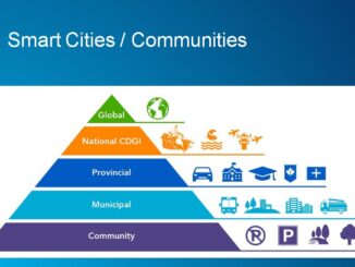
Developing a roadmap for a reliable map of underground utilities in Singapore

21 October 2019 Geoff Zeiss

In 2017, the Singapore Land Authority (SLA), Singapore-ETH Centre, and the Geomatics Department of the City of Zürich started the Digital Underground project as a first step toward achieving an accurate, current, and complete map […]

Access to Spatial Data

Accelerating progress in open spatial data infrastructure at the municipal level in Canada

20 October 2019 Geoff Zeiss

At the SDI Summit in Quebec City Gordon Plunkett offered an interesting perspective on the penetration of open spatial data infrastructure (SDI) at the municipal level in Canada.  Local governments are traditionally responsible for local […]

Between the Poles – The Geoff Zeiss Archives

Reliable statistics provide a foundation for improving pipeline safety

14 October 2019 Geoff Zeiss

Pipeline incidents (gas distribution, gas transmission, gas gathering and hazardous liquid) resulting from excavation damage 2005-2019 “If you can’t measure it, you can’t improve it.” (Peter Drucker) is a maxim that applies to airline accidents, […]

Between the Poles – The Geoff Zeiss Archives

Open source geospatial technology enables cost-effective solutions in many domains

7 October 2019 Geoff Zeiss

At the GITA Pipeline Forum in Houston, an enthralling presentation by Rich Henry of Pivvot, a recent startup that builds solutions for pipeline routing and other applications, highlighted how open source geospatial technology is transforming […]

Between the Poles – The Geoff Zeiss Archives

New regulations for pipeline safety creates opportunities for geospatial professionals

4 October 2019 Geoff Zeiss

New federal regulations in the U.S. will likely more than double the areas where higher levels of pipeline integrity maintenance standards are mandated by federal legislation.  Identifying these areas is more complex creating opportunities for […]

Between the Poles – The Geoff Zeiss Archives

Comparison of metrics and trends for commercial airline accidents and underground utility damage

30 September 2019 Geoff Zeiss

Underground utility infrastructure represents a substantial risk to workers and the public.  Most damage to underground infrastructure is the result of construction excavation, recent examples include Murrieta CA, Durham NC, and San Francisco CA.  But […]

3D printing

BIM and geospatial for facilities management is penetrating construction

18 September 2019 Geoff Zeiss

Typically at BIMForum events, the audience is composed of architects, engineers and construction contractors, with the odd owner, but rarely facilities management (FM) folks. At this year’s BIMForum 2019 conference in St Louis several talks […]

3D data

Is it ethical to bury dangerous infrastructure in the public right-of-way without accurate maps ?

10 September 2019 Geoff Zeiss

This is a readable version of a video that I submitted to the EthicalGEO site. Without accurate maps of where underground infrastructure is located, every construction project has the potential to become a disaster site. […]

Posts pagination

« 1 … 19 20 21 … 314 »

Events

Notice
There are no upcoming events.

View All Events

Services

  • Post a Job
  • Post an Ad
  • Post an Event
  • Post a Directory Listing
  • Post a Press Release
  • Media Kit
  • My Account
  • Login

Jobs

Post a Job
  • GIS Technologist II
    Fernie, B.C.
  • GIS I TECHNOLOGIST
    Fernie, B.C.
  • Survey Crew Chief
    Langley, BC
  • Survey Tech
    Kamloops, BC
View All Jobs
  • Directories
    • Associations Directory
    • Industry Directory
    • Education Programs
    • Open Data
  • Volunteer
    • Start a GoGeomatics Group
    • Editors & Writers Group
  • About Us
    • GoGeomatics Media Kit
    • Who We Are
    • Contact Us
    • FAQ’s
    • Advertising
    • Marketing
  • Subscribe
GoGeomatics
GoGeomatics is the largest and most popular communications hub promoting the Canadian geospatial community. The business was incorporated in 2011. GoGeomatics hosts over 100 fun, free, location technology networking events each year in cities across Canada.

© 2026 GoGeomatics

  • facebook
  • Twitter
  • Linkedin
  • Youtube
  • Linkedin Group