• facebook
  • Twitter
  • Linkedin
  • Youtube
  • Linkedin Group
  • Post a Job
  • Post an Ad
  • Post an Event
  • Post a Directory Listing
  • Post a Press Release
  • Media Kit
  • My Account
  • Login
GoGeomatics
  • MAGAZINE
    • BIM & GIS
    • Community
    • Conference news
    • Earth Observation
    • Education & Careers
    • GEOAI
    • Announcements
    • Reality Capture & Lidar
    • Science
    • Technology
    • Between the Poles
  • Directories
    • ASSOCIATION
    • INDUSTRY
    • EDUCATION
    • Open Data
  • EVENTS
    • GeoIgnite Events
    • Events Calendar
    • GoGeomatics Meetups
  • Services
    • Advertising
    • Marketing
    • Post a Job
    • Post an Ad
    • Post an Event
    • Post a Press Release
    • Post a Directory Listing
    • Media Kit
    • Web Design
  • Find a Job
  • Volunteer
    • Start a GoGeomatics Group
    • Editors & Writers Group
  • About Us
    • About Us
    • Contact Us
    • Frequently Asked Questions
  • Videos
HomeBetween the Poles – The Geoff Zeiss Archives

Between the Poles – The Geoff Zeiss Archives

3D Visualization

3D Is Helping Address the Aging Workforce Challenge

8 October 2010 Geoff Zeiss

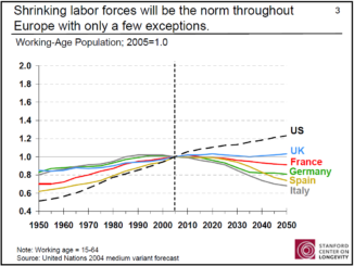
One of my takeaways from the annual GITA ANZ 2010 conference in Brisbane earlier this year was from Graeme Anthonsen’s presentation in which he outlined the cadet program that City West Water has implemented to […]

Between the Poles – The Geoff Zeiss Archives

Green Power and Smart Grid in Ontario – How Is It Being Financed ?

6 October 2010 Geoff Zeiss

As I have blogged on several occasions Ontario is in several ways leading the charge in the green power/smart grid revolution in North America. Ontario’s roll-out of smart meters together with time-of-use electric power rates […]

Between the Poles – The Geoff Zeiss Archives

Standard Specifications and Drawings for Municipal Construction Projects and Data Quality

5 October 2010 Geoff Zeiss

I have blogged in the past (here, here, here and here) about the poor data quality of utility records databases that has serious implications.  It can lead to  such things as unreliable reports prepared for management and […]

Between the Poles – The Geoff Zeiss Archives

FGDC US Address Standard Nears Completion

4 October 2010 Geoff Zeiss

In 2005 URISA petitioned the Federal Geographic Data Committee to allow it to develop a standard for addresses in the US.  The petition was granted and the project to develope the United States Thoroughfare, Landmark, […]

Access to Spatial Data

Proposed OGC Standard for Geosynchronization

4 October 2010 Geoff Zeiss

One of the talks I attended at the URISA conference last week in Orlando was presented by Raj Singh of the Open Geospatial Consortium (OGC) on the subject of “geosynchronization”.  This has nothing to do […]

Between the Poles – The Geoff Zeiss Archives

BIM Recommended for UK Government Procurement

4 October 2010 Geoff Zeiss

The chief construction adviser to the UK Government has said that Building Information Modelling (BIM) will become a part of the procurement of public buildings in the UK and indicated that bidders and contractors on […]

Between the Poles – The Geoff Zeiss Archives

GITA 2011 Intelligent Infrastructure for a Sustainable Future – Call for Abstracts

4 October 2010 Geoff Zeiss

The GITA Geospatial Solutions Conference will be held April 10-14, 2011 in Grapevine, Texas.  The themes of the conference will be smart grids and sustainable infrastructure.  GITA has issued a call for presentations and is […]

Between the Poles – The Geoff Zeiss Archives

Autodesk Announces AutoCAD WS for the Cloud

30 September 2010 Geoff Zeiss

I blogged previously about Project Butterfly, an Autodesk Labs Technology Preview that allowed AutoCAD users to edit AutoCAD drawings over the web just using a Web browser.  Autodesk has announced the commercial availability of AutoCAD […]

Posts pagination

« 1 … 218 219 220 … 314 »

Events

Notice
There are no upcoming events.

View All Events

Services

  • Post a Job
  • Post an Ad
  • Post an Event
  • Post a Directory Listing
  • Post a Press Release
  • Media Kit
  • My Account
  • Login

Jobs

Post a Job
  • GIS Technologist II
    Fernie, B.C.
  • GIS I TECHNOLOGIST
    Fernie, B.C.
  • Survey Manager
    Kamloops, BC
  • Civil Survey/ Engineering Technician (two positions available)
    Wolfville Nova Scotia
View All Jobs
  • Directories
    • Associations Directory
    • Industry Directory
    • Education Programs
    • Open Data
  • Volunteer
    • Start a GoGeomatics Group
    • Editors & Writers Group
  • About Us
    • GoGeomatics Media Kit
    • Who We Are
    • Contact Us
    • FAQ’s
    • Advertising
    • Marketing
  • Subscribe
GoGeomatics
GoGeomatics is the largest and most popular communications hub promoting the Canadian geospatial community. The business was incorporated in 2011. GoGeomatics hosts over 100 fun, free, location technology networking events each year in cities across Canada.

© 2026 GoGeomatics

  • facebook
  • Twitter
  • Linkedin
  • Youtube
  • Linkedin Group