• facebook
  • Twitter
  • Linkedin
  • Youtube
  • Linkedin Group
  • Post a Job
  • Post an Ad
  • Post an Event
  • Post a Directory Listing
  • Post a Press Release
  • Media Kit
  • My Account
  • Login
GoGeomatics
  • MAGAZINE
    • BIM & GIS
    • Community
    • Conference news
    • Earth Observation
    • Education & Careers
    • GEOAI
    • Announcements
    • Reality Capture & Lidar
    • Science
    • Technology
    • Between the Poles
  • Directories
    • ASSOCIATION
    • INDUSTRY
    • EDUCATION
    • Open Data
  • EVENTS
    • GeoIgnite Events
    • Events Calendar
    • GoGeomatics Meetups
  • Services
    • Advertising
    • Marketing
    • Post a Job
    • Post an Ad
    • Post an Event
    • Post a Press Release
    • Post a Directory Listing
    • Media Kit
    • Web Design
  • Find a Job
  • Volunteer
    • Start a GoGeomatics Group
    • Editors & Writers Group
  • About Us
    • About Us
    • Contact Us
    • Frequently Asked Questions
  • Videos
HomeBetween the Poles – The Geoff Zeiss Archives

Between the Poles – The Geoff Zeiss Archives

Between the Poles – The Geoff Zeiss Archives

Assessing the PAS 128 quality standard for underground utility location

23 May 2019 Geoff Zeiss

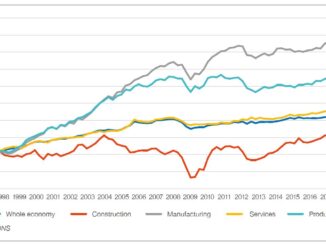
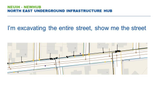
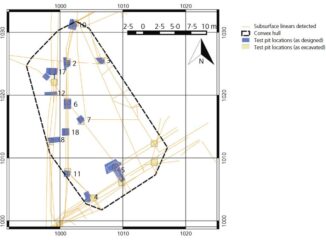
A very interesting recent academic study from the University of Birmingham investigates the effectiveness of the British PAS128 standard for underground utilities.  Four different  utility survey specialist firms were invited to locate (without potholing) underground […]

No Picture
3D data

City regulation reduces underground utility damage during excavations

20 May 2019 Geoff Zeiss

Every year there are 400,000 incidents of damage to underground utilities during excavation in the U.S.  This is a world wide problem but some jurisdictions have found ways to reduce the number of underground utility […]

Between the Poles – The Geoff Zeiss Archives

Improving and sharing geospatial information about the subsurface in England

14 May 2019 Geoff Zeiss

NEDO estimates that about 50% of time over-runs on commercial building projects are caused by unforeseen ground conditions.* There are two aspects to the problems associated with the subsurface.  One is geotechnics, soil, ground water, […]

Between the Poles – The Geoff Zeiss Archives

Tracking a construction project in real-time with smartphones

7 May 2019 Geoff Zeiss

Many see handheld scanning as revolutionizing the construction sector.  The Dot Product handheld scanner and Faro Freestyle introduced in 2013 were among the first multi-sensor devices (IR laser and photo cameras) targeted at professionals, especially […]

3D data

National underground infrastructure map could deliver £245 million per year to UK

2 May 2019 Geoff Zeiss

The Geospatial Commission’s Annual Plan 2019/20 describes the activities that it plans to undertake in 2019/2020 to develop the UK’s National Geospatial Strategy.  The first project announced for 2019/2020 is its intention to fund two […]

3D data

Role of surveyors in digitally mapping underground utilities

1 May 2019 Geoff Zeiss
Asset management

Geospatial Commission announces UK registry of underground utilities

29 April 2019 Geoff Zeiss

Every construction project devotes significant efforts to locating underground utilities prior to and during construction. But this information is rarely shared and the location of underground infrastructure is recaptured over and over again.  To begin […]

3D data

British standard PAS128 for underground utility location to be updated

24 April 2019 Geoff Zeiss

Belgium underground gas line explosion during excavation 2003 As we are reminded by the recent underground utility hits in San Francisco, CA, Durham, NC, and Calgary, Alberta, not knowing the location underground utilities represents a […]

Posts pagination

« 1 … 23 24 25 … 314 »

Events

Notice
There are no upcoming events.

View All Events

Services

  • Post a Job
  • Post an Ad
  • Post an Event
  • Post a Directory Listing
  • Post a Press Release
  • Media Kit
  • My Account
  • Login

Jobs

Post a Job
  • GIS Technologist II
    Fernie, B.C.
  • GIS I TECHNOLOGIST
    Fernie, B.C.
  • Survey Crew Chief
    Langley, BC
  • Survey Tech
    Kamloops, BC
View All Jobs
  • Directories
    • Associations Directory
    • Industry Directory
    • Education Programs
    • Open Data
  • Volunteer
    • Start a GoGeomatics Group
    • Editors & Writers Group
  • About Us
    • GoGeomatics Media Kit
    • Who We Are
    • Contact Us
    • FAQ’s
    • Advertising
    • Marketing
  • Subscribe
GoGeomatics
GoGeomatics is the largest and most popular communications hub promoting the Canadian geospatial community. The business was incorporated in 2011. GoGeomatics hosts over 100 fun, free, location technology networking events each year in cities across Canada.

© 2026 GoGeomatics

  • facebook
  • Twitter
  • Linkedin
  • Youtube
  • Linkedin Group