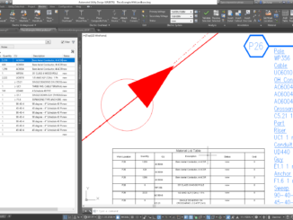
• facebook
  • Twitter
  • Linkedin
  • Youtube
  • Linkedin Group
  • Post a Job
  • Post an Ad
  • Post an Event
  • Post a Directory Listing
  • Post a Press Release
  • Media Kit
  • My Account
  • Login
GoGeomatics
  • MAGAZINE
    • BIM & GIS
    • Community
    • Conference news
    • Earth Observation
    • Education & Careers
    • GEOAI
    • Announcements
    • Reality Capture & Lidar
    • Science
    • Technology
    • Between the Poles
  • Directories
    • ASSOCIATION
    • INDUSTRY
    • EDUCATION
    • Open Data
  • EVENTS
    • GeoIgnite Events
    • Events Calendar
    • GoGeomatics Meetups
  • Services
    • Advertising
    • Marketing
    • Post a Job
    • Post an Ad
    • Post an Event
    • Post a Press Release
    • Post a Directory Listing
    • Media Kit
    • Web Design
  • Find a Job
  • Volunteer
    • Start a GoGeomatics Group
    • Editors & Writers Group
  • About Us
    • About Us
    • Contact Us
    • Frequently Asked Questions
  • Videos
HomeBetween the Poles – The Geoff Zeiss Archives

Between the Poles – The Geoff Zeiss Archives

No Picture
3D data

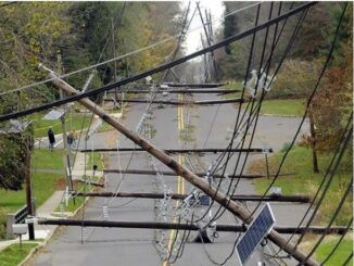
First international workshop on digitally mapping the underground

9 April 2019 Geoff Zeiss

At Geospatial World Forum 2019 the first international workshop on digitally mapping the underground Underground mapping for resilient infrastructure: Datafication of the Underground was organized by Rob van de Velde and Paul Janssen of Geonovum.  […]

3D data

Automating transmission line inspections with BVLOS drones and machine learning

2 April 2019 Geoff Zeiss

Transmission line inspections for vegetation management and other purposes are essential in ensuring grid reliability and resilence.  They are generally performed by manned helicopters or by a ground crew.  Data is collected with cameras and […]

3D data

Urgent: Standards-based geospatial + BIM interoperability requires broad vendor participation

29 March 2019 Geoff Zeiss

At the International Standards Summit 2019 in Düsseldorf a group of people representing owners, engineering and construction firms, vendors and services providers in the AEC space, and standards organization Open Geospatial Consortium (OGC) and buildingSMART […]

Augmented reality

AR enables better grid damage assessments and improves quality of utility GIS

26 March 2019 Geoff Zeiss

Maintaining accurate, up-to-date GIS data has been a challenge for utility and communications firms for decades.  Inefficient CAD/GIS workflows result in utility GIS quality degrading with time.  Now with business drivers such as implementing a […]

Between the Poles – The Geoff Zeiss Archives

A bit of early history of open source geospatial

25 March 2019 Geoff Zeiss

It is now 20 years since the University of Minnesota (UMN) MapServer 3.0 was made open source. Daniel Morissette (@dmorissette) has posted a bit of interesting history on Twitter about the early days of open […]

Aging workforce

Power utility identifies 60-70% productivity improvement by integrating engineering design, GIS and enterprise systems

19 March 2019 Geoff Zeiss

In the last few years strong business drivers for improving power distribution design productivity including an aging and shrinking workforce, an accelerating transition to the smart grid and a rapidly changing utility business model have […]

Asset management

Bringing reliable near real-time GIS within reach of every utility

12 March 2019 Geoff Zeiss

Workflows for ensuring utility GIS quality are fundamentally broken and have been for decades.  Integrating CAD and GIS into an efficient workflow has been a challenge and it has simply not been a priority in […]

3D data

Automating vegetation management for electric power transmission lines using deep learning with LIDAR

26 February 2019 Geoff Zeiss

With FAA rules permitting beyond visual line of sight (BVLOS) UAVs available through Part 107 waivers the cost of capturing the data required for vegetation management for power lines, whether transmission or distribution, could drop […]

Posts pagination

« 1 … 24 25 26 … 314 »

Events

Notice
There are no upcoming events.

View All Events

Services

  • Post a Job
  • Post an Ad
  • Post an Event
  • Post a Directory Listing
  • Post a Press Release
  • Media Kit
  • My Account
  • Login

Jobs

Post a Job
  • GIS Technologist II
    Fernie, B.C.
  • GIS I TECHNOLOGIST
    Fernie, B.C.
  • Civil Survey/ Engineering Technician (two positions available)
    Wolfville Nova Scotia
  • Survey Crew Chief
    Langley, BC
View All Jobs
  • Directories
    • Associations Directory
    • Industry Directory
    • Education Programs
    • Open Data
  • Volunteer
    • Start a GoGeomatics Group
    • Editors & Writers Group
  • About Us
    • GoGeomatics Media Kit
    • Who We Are
    • Contact Us
    • FAQ’s
    • Advertising
    • Marketing
  • Subscribe
GoGeomatics
GoGeomatics is the largest and most popular communications hub promoting the Canadian geospatial community. The business was incorporated in 2011. GoGeomatics hosts over 100 fun, free, location technology networking events each year in cities across Canada.

© 2026 GoGeomatics

  • facebook
  • Twitter
  • Linkedin
  • Youtube
  • Linkedin Group