• facebook
  • Twitter
  • Linkedin
  • Youtube
  • Linkedin Group
  • Post a Job
  • Post an Ad
  • Post an Event
  • Post a Directory Listing
  • Post a Press Release
  • Media Kit
  • My Account
  • Login
GoGeomatics
  • MAGAZINE
    • BIM & GIS
    • Community
    • Conference news
    • Earth Observation
    • Education & Careers
    • GEOAI
    • Announcements
    • Reality Capture & Lidar
    • Science
    • Technology
    • Between the Poles
  • Directories
    • ASSOCIATION
    • INDUSTRY
    • EDUCATION
    • Open Data
  • EVENTS
    • GeoIgnite Events
    • Events Calendar
    • GoGeomatics Meetups
  • Services
    • Advertising
    • Marketing
    • Post a Job
    • Post an Ad
    • Post an Event
    • Post a Press Release
    • Post a Directory Listing
    • Media Kit
    • Web Design
  • Find a Job
  • Volunteer
    • Start a GoGeomatics Group
    • Editors & Writers Group
  • About Us
    • About Us
    • Contact Us
    • Frequently Asked Questions
  • Videos
HomeBetween the Poles – The Geoff Zeiss Archives

Between the Poles – The Geoff Zeiss Archives

Between the Poles – The Geoff Zeiss Archives

EPRI curates open utility-related training datasets for deep learning applications

15 January 2019 Geoff Zeiss

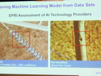
Automatic feature extraction or image classification using artificial intelligence (AI) algorithms has been successfully applied in several domains, for example, in recognizing landmarks, dogs, cars and other objects in consumer photos and detecting building footprints […]

3D data

Progress toward a unified model for underground infrastructure and geology

8 January 2019 Geoff Zeiss

TNO, Geological Survey of the Netherlands Information about the location, condition and interdependencies of the infrastructure and geology below our feet is poor or lacking.  Even though information about what is below ground is revealed […]

3D data

Growing evidence of the benefits of an integrated BIM+geospatial full lifecycle approach to construction

2 January 2019 Geoff Zeiss

Building information modeling (BIM) has been applied to design-build construction projects for many years. A growing number of countries are mandating BIM for public projects.  While the UK government has said that “…we know that […]

3D data

3D BIM + geospatial full lifecycle metro rail project aims at eliminating data loss

27 December 2018 Geoff Zeiss

This year’s winner of a special recognition award at Year in Infrastructure was Maharashtra Metro Rail Corporation Ltd for its Nagpur Metro Asset Information Management System which implemented a digital twin and a tagging scheme […]

Between the Poles – The Geoff Zeiss Archives

Firm realizes ROI of 203% by integrating CAD and GIS for fiber network management

18 December 2018 Geoff Zeiss

Integrating CAD and GIS into an efficient workflow for records management (aka network documentation) has been a challenge for utility and telecom operators for decades.  While utility and telecom operators have found ways to address […]

3D data

BIM and reality modeling eliminate change orders for brownfield substation expansion

11 December 2018 Geoff Zeiss

Companies are recognizing the benefits of an integrated geospatial and building information modeling (BIM) approach to design and construction. At Bentley‘s the Year in Infrastructure 2018 Conference in London, the winner of the Year in Infrastructure […]

Between the Poles – The Geoff Zeiss Archives

Latest report estimates 400,000 underground utility damage events per year in North America

10 December 2018 Geoff Zeiss

The Common Ground Alliance (CGA) has released its latest DIRT (Damage Information Reporting Tool) Report covering 2015, 2016 and 2017.   To make it possible to estimate the total number of events and to allow comparison […]

3D data

State DOT saves millions by creating 3D map of underground utilities prior to design

5 December 2018 Geoff Zeiss

Unknown or inaccurately located underground utilities can make or break a highway construction project’s schedule.  For the largest construction project in the state of Alabama’s history, the Alabama Department of Transportation (ALDOT) used ground penetrating […]

Posts pagination

« 1 … 26 27 28 … 314 »

Events

Notice
There are no upcoming events.

View All Events

Services

  • Post a Job
  • Post an Ad
  • Post an Event
  • Post a Directory Listing
  • Post a Press Release
  • Media Kit
  • My Account
  • Login

Jobs

Post a Job
  • GIS Technologist II
    Fernie, B.C.
  • GIS I TECHNOLOGIST
    Fernie, B.C.
  • Civil Survey/ Engineering Technician (two positions available)
    Wolfville Nova Scotia
  • Survey Crew Chief
    Langley, BC
View All Jobs
  • Directories
    • Associations Directory
    • Industry Directory
    • Education Programs
    • Open Data
  • Volunteer
    • Start a GoGeomatics Group
    • Editors & Writers Group
  • About Us
    • GoGeomatics Media Kit
    • Who We Are
    • Contact Us
    • FAQ’s
    • Advertising
    • Marketing
  • Subscribe
GoGeomatics
GoGeomatics is the largest and most popular communications hub promoting the Canadian geospatial community. The business was incorporated in 2011. GoGeomatics hosts over 100 fun, free, location technology networking events each year in cities across Canada.

© 2026 GoGeomatics

  • facebook
  • Twitter
  • Linkedin
  • Youtube
  • Linkedin Group