• facebook
  • Twitter
  • Linkedin
  • Youtube
  • Linkedin Group
  • Post a Job
  • Post an Ad
  • Post an Event
  • Post a Directory Listing
  • Post a Press Release
  • Media Kit
  • My Account
  • Login
GoGeomatics
  • MAGAZINE
    • BIM & GIS
    • Community
    • Conference news
    • Earth Observation
    • Education & Careers
    • GEOAI
    • Announcements
    • Reality Capture & Lidar
    • Science
    • Technology
    • Between the Poles
  • Directories
    • ASSOCIATION
    • INDUSTRY
    • EDUCATION
    • Open Data
  • EVENTS
    • GeoIgnite Events
    • Events Calendar
    • GoGeomatics Meetups
  • Services
    • Advertising
    • Marketing
    • Post a Job
    • Post an Ad
    • Post an Event
    • Post a Press Release
    • Post a Directory Listing
    • Media Kit
    • Web Design
  • Find a Job
  • Volunteer
    • Start a GoGeomatics Group
    • Editors & Writers Group
  • About Us
    • About Us
    • Contact Us
    • Frequently Asked Questions
  • Videos
HomeBetween the Poles – The Geoff Zeiss Archives

Between the Poles – The Geoff Zeiss Archives

Total articles: 2505

Between the Poles – The Geoff Zeiss Archives

UK’s Geospatial Commission estimates ROI of £30 benefit for every £1 invested in National Underground Asset Register

5 November 2021 Geoff Zeiss

It is estimated that accidental underground utility strikes cost the UK economy £2.4 billion every year. A top priority of the the Geospatial Commission, an agency of the UK government tasked with extracting more value […]

Read more

No Picture
3D data

Revision to Australian AS 5488 Classification of Subsurface Utility Information

1 November 2021 Geoff Zeiss

Recently national standards relating to underground infrastructure have been revised or are being revised.  These include the US ASCE 38 with a new title Standard Guideline for Investigating and Documenting Existing Utilities, the UK PAS […]

Read more

3D data

A user platform for digital twins of underground utility infrastructure

26 October 2021 Geoff Zeiss

The foundation for digital twins of cities, regions and nations are digital geometric models.  Developing these models have become a priority for a number of jurisdictions around the world. To date the emphasis has been […]

Read more

Asset management

Pilot project to create national map of UK energy infrastructure launched

25 October 2021 Geoff Zeiss

A proof-of-concept project to develop a National Energy Systems Map (NESM) has been launched by the UK’s electricity and gas networks. The pilot project will give customers information about energy network assets, where those assets […]

Read more

Between the Poles – The Geoff Zeiss Archives

Grid resilience demands we understand our infrastructure above and below ground

21 October 2021 Geoff Zeiss

Jay Cadman, SVP Enterprise, IQGeo As the glue interlinking everything from the industrial ‘Internet of Things’ to smart grids and underpinning the real-time social and economic services of the future, full fiber and 5G is […]

Read more

3D data

Digitalizing the as-builting process essential for accurate underground utility mapping

14 September 2021 Geoff Zeiss

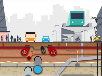
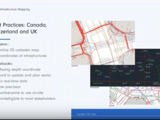
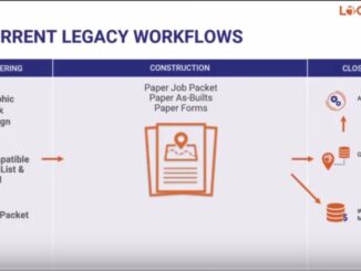
Over the past decades electric, gas, water, and telecom utilities have poured millions into digitalizing the graphic design/work management and GIS/records management processes. But in spite of this the decades-old as-builting process remains marred by […]

Read more

No Picture
Between the Poles – The Geoff Zeiss Archives

Build phase of UK’s National Underground Asset Register (NUAR) announced

7 September 2021 Geoff Zeiss

What began as a grassroots initiative that brought together network operators and local government agencies in the North East of England has evolved into the National Underground Asset Register (NUAR), a national program supported by […]

Read more

3D data

Gyro mapping has many advantages over other technologies in mapping underground utilities

1 September 2021 Geoff Zeiss

An innovative technology that is being increasingly applied to locating existing pipe networks or those installed by way of horizontal drilling is inertial or gyro locating. Using this technology, it is possible to map networks […]

Read more

3D data

Major advance in capturing survey-grade location information for exposed underground utilities

24 August 2021 Geoff Zeiss

A major gap in the construction process is the unavailability of reliable information about the location of underground utilities for civil engineering construction projects such as highways, railways and pipelines. Mapping underground infrastructure is benefiting […]

Read more

3D data

Mobile + cloud solutions are revolutionizing the capture and sharing of reliable underground infrastructure location data

17 August 2021 Geoff Zeiss

A major gap in the construction process is the unavailability of reliable information about the location of underground utilities for civil engineering construction projects such as highways, railways and pipelines. All states and provinces in […]

Read more

No Picture
Between the Poles – The Geoff Zeiss Archives

Two states mandate subsurface utility engineering surveys during pre-construction

2 August 2021 Geoff Zeiss

A major gap in the construction process is the unavailability of reliable information about the location of underground utilities during the design stage of civil engineering construction projects such as highways and pipelines. All states […]

Read more

Between the Poles – The Geoff Zeiss Archives

Latest statistics reveal reducing damage to underground infrastructure remains a challenge

29 July 2021 Geoff Zeiss

The ORCGA has just released the 2020 Damage Information Reporting Tool (DIRT) Report.  The report is the result of the efforts made by the ORCGA to collect and compile data about the occurrence of events […]

Read more

3D data

Democratizing reality capture for underground pipeline and utility infrastructure

19 July 2021 Geoff Zeiss

A revolution is happening in how we map new underground infrastructure. Instead of the paper as-builts submitted after the completion of construction for a new pipeline or other infrastructure, network owners may now request a […]

Read more

3D data

France’s DT DICT system effective in reducing damage to underground utilities during construction

12 July 2021 Geoff Zeiss

Since 2013 France has implemented a national damage prevention system that requires achieving 40 cm accuracy for the location of all critical underground network infrastructure prior to beginning construction.  Annual statistics reveal a decreasing trend […]

Read more

Asset management

UK’s bottom-up/top-down approach to creating a voluntary National Underground Asset Registry

6 July 2021 Geoff Zeiss

Many jurisidictions are recognizing the human and economic cost of not knowing the location of underground utilities and other infrastructure and are looking at legislative, regulatory, technological, business practice and other measures to find ways […]

Read more

Asset management

UK BIM adoption survey reveals facilities/asset management trails other disciplines

5 July 2021 Geoff Zeiss

The UK Government as part of its building information modeling (BIM) initiative has said repeatedly that it expects the big payoff of a digital model will be during operations and maintenance, which typically represents 80% […]

Read more

Between the Poles – The Geoff Zeiss Archives

Accelerating capital investment in new technology for mapping underground infrastructure

1 July 2021 Geoff Zeiss

The $10 trillion global construction industry is facing a crisis. For many of the world’s advanced economies productivity in the construction sector has been stagnant for years.  According to a McKinsey study whereas the average […]

Read more

Between the Poles – The Geoff Zeiss Archives

Canadian government’s approach to managing underground infrastructure on federal land

29 June 2021 Geoff Zeiss

Public Services and Procurement Canada (PSPC) is responsible for procurement and real property management for federal departments and agencies. There are about a hundred departments and agencies in the Federal government, of which 23 are […]

Read more

Between the Poles – The Geoff Zeiss Archives

One-call centre in England reports inaccurate and missing plans a leading cause of underground utility damage

28 June 2021 Geoff Zeiss

In the UK the total number of incidents of utility strikes every year is unknown. Statistics on underground utility strikes such as those collected by the Common Ground Alliance in North America are not available.  […]

Read more

3D data

Ontario adopts policy to reduce underground utility risk on public construction projects through collaboration

23 June 2021 Geoff Zeiss

Utility locates and relocation work have historically been the cause of construction delays on public construction projects, particularly in urban areas with dense population and the commensurate underground utility and telecom infrastructure. With the massive […]

Read more

Posts pagination

« 1 2 3 4 … 126 »

Events

May 11
May 11 @ 8:00 am - May 13 @ 5:00 pm

GeoIgnite 2026

May 25
May 25 - May 28

National Surveyors’ Conference 2026

May 27
May 27 @ 8:00 am - May 29 @ 5:00 pm

Canadian Cartographic Association Conference 2026

May 27
May 27 @ 8:00 am - May 29 @ 5:00 pm

CCA 2026 Conference: Coast to Coast to Coast

Jun 1
June 1 - June 4

CAG/CARTO Annual Meeting 2026

View Calendar

View All Events

Services

  • Post a Job
  • Post an Ad
  • Post an Event
  • Post a Directory Listing
  • Post a Press Release
  • Media Kit
  • My Account
  • Login

Jobs

Post a Job
  • Geospatial Analytical Technician / Technicien, analyses géospatiales; technicienne, analyses géospatiales
    Peterborough
  • GIS Technologist II
    Fernie, B.C.
  • GIS I TECHNOLOGIST
    Fernie, B.C.
  • Hydrogeologist
    Calgary, Alberta
View All Jobs
  • Directories
    • Associations Directory
    • Industry Directory
    • Education Programs
    • Open Data
  • Volunteer
    • Start a GoGeomatics Group
    • Editors & Writers Group
  • About Us
    • GoGeomatics Media Kit
    • Who We Are
    • Contact Us
    • FAQ’s
    • Advertising
    • Marketing
  • Subscribe
GoGeomatics
GoGeomatics is the largest and most popular communications hub promoting the Canadian geospatial community. The business was incorporated in 2011. GoGeomatics hosts over 100 fun, free, location technology networking events each year in cities across Canada.

© 2026 GoGeomatics

  • facebook
  • Twitter
  • Linkedin
  • Youtube
  • Linkedin Group