• facebook
  • Twitter
  • Linkedin
  • Youtube
  • Linkedin Group
  • Post a Job
  • Post an Ad
  • Post an Event
  • Post a Directory Listing
  • Post a Press Release
  • Media Kit
  • My Account
  • Login
GoGeomatics
  • MAGAZINE
    • BIM & GIS
    • Community
    • Conference news
    • Earth Observation
    • Education & Careers
    • GEOAI
    • Announcements
    • Reality Capture & Lidar
    • Science
    • Technology
    • Between the Poles
  • Directories
    • ASSOCIATION
    • INDUSTRY
    • EDUCATION
    • Open Data
  • EVENTS
    • GeoIgnite Events
    • Events Calendar
    • GoGeomatics Meetups
  • Services
    • Advertising
    • Marketing
    • Post a Job
    • Post an Ad
    • Post an Event
    • Post a Press Release
    • Post a Directory Listing
    • Media Kit
    • Web Design
  • Find a Job
  • Volunteer
    • Start a GoGeomatics Group
    • Editors & Writers Group
  • About Us
    • About Us
    • Contact Us
    • Frequently Asked Questions
  • Videos
HomeBetween the Poles – The Geoff Zeiss Archives

Between the Poles – The Geoff Zeiss Archives

Between the Poles – The Geoff Zeiss Archives

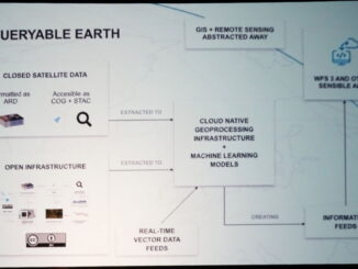
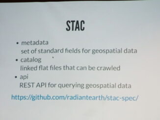
Open developer-friendly standard for querying satellite imagery

17 May 2018 Geoff Zeiss

One of the things that is required to make the vast quantity of satellite imagery easily searchable is a common way to query satellite data.  The SpatioTemporal Asset Catalog, known as STAC, is an open […]

Between the Poles – The Geoff Zeiss Archives

Enabling the rest of us to find actionable information in huge volumes of satellite data

16 May 2018 Geoff Zeiss

There is a huge volume of satellite imagery that is being captured and has been captured over the past couple of decades.  The challenge is to automatically find objects such as ships, trees, buildings, or […]

Between the Poles – The Geoff Zeiss Archives

How much does it cost to run a FOSS4G conference ?

15 May 2018 Geoff Zeiss

Since the formation of the Open Source Geospatial Foundation (OSGEO) in 2006, there has been an annual FOSS4G event that brings together open source geospatial developers, users and supporters from around the world. The first […]

Between the Poles – The Geoff Zeiss Archives

Extensive use of geospatial open source software by the National Geospatial Intelligence Agency

14 May 2018 Geoff Zeiss

The National Geospatial-Intelligence Agency (NGA) is a U.S. Government intelligence agency and Department of Defence combat support agency. But it also provides support for disaster relief and humanitarian aid. At FOSS4GNA today in St. Louis […]

Access to Spatial Data

First step toward developing a national infrastructure map to enable smart investments

7 May 2018 Geoff Zeiss

In its 2017 Infrastructure Report Card, the American Society of Civil Engineers (ASCE) assigned an overall grade of D+ to U.S. infrastructure. Addressing the problem of bringing national infrastructure up to a standard where it […]

Between the Poles – The Geoff Zeiss Archives

Report identifies opportunities for technology innovation in subsurface utility detection and mapping

27 April 2018 Geoff Zeiss

Since first writing about accelerating world wide initiatives to map underground utilities in 2014 there has been increasing acceleration in the U.S. in technology innovation and development.  Motivated by the escalating interest in underground infrastructure […]

Between the Poles – The Geoff Zeiss Archives

Innovative look ahead radar technology would make trenchless digging safer

25 April 2018 Geoff Zeiss

Investment in research and development of technology for detecting and mapping underground infrastructure is accelerating. The Common Ground Alliance (CGA) has initiated an annual Common Ground Alliance Technology Report. The report not only describes existing […]

Between the Poles – The Geoff Zeiss Archives

Deep learning enables automated extraction of building footprints and road networks from satellite imagery

16 April 2018 Geoff Zeiss

Automated feature extraction from satellite imagery has made major progress in the last year. Accurate building footprints extracted from high resolution satellite imagery are available from companies such as Ecopia (which has just announced a […]

Posts pagination

« 1 … 34 35 36 … 314 »

Events

Notice
There are no upcoming events.

View All Events

Services

  • Post a Job
  • Post an Ad
  • Post an Event
  • Post a Directory Listing
  • Post a Press Release
  • Media Kit
  • My Account
  • Login

Jobs

Post a Job
  • GIS Technologist II
    Fernie, B.C.
  • GIS I TECHNOLOGIST
    Fernie, B.C.
  • Civil Survey/ Engineering Technician (two positions available)
    Wolfville Nova Scotia
  • Survey Crew Chief
    Langley, BC
View All Jobs
  • Directories
    • Associations Directory
    • Industry Directory
    • Education Programs
    • Open Data
  • Volunteer
    • Start a GoGeomatics Group
    • Editors & Writers Group
  • About Us
    • GoGeomatics Media Kit
    • Who We Are
    • Contact Us
    • FAQ’s
    • Advertising
    • Marketing
  • Subscribe
GoGeomatics
GoGeomatics is the largest and most popular communications hub promoting the Canadian geospatial community. The business was incorporated in 2011. GoGeomatics hosts over 100 fun, free, location technology networking events each year in cities across Canada.

© 2026 GoGeomatics

  • facebook
  • Twitter
  • Linkedin
  • Youtube
  • Linkedin Group