• facebook
  • Twitter
  • Linkedin
  • Youtube
  • Linkedin Group
  • Post a Job
  • Post an Ad
  • Post an Event
  • Post a Directory Listing
  • Post a Press Release
  • Media Kit
  • My Account
  • Login
GoGeomatics
  • MAGAZINE
    • BIM & GIS
    • Community
    • Conference news
    • Earth Observation
    • Education & Careers
    • GEOAI
    • Announcements
    • Reality Capture & Lidar
    • Science
    • Technology
    • Between the Poles
  • Directories
    • ASSOCIATION
    • INDUSTRY
    • EDUCATION
    • Open Data
  • EVENTS
    • GeoIgnite Events
    • Events Calendar
    • GoGeomatics Meetups
  • Services
    • Advertising
    • Marketing
    • Post a Job
    • Post an Ad
    • Post an Event
    • Post a Press Release
    • Post a Directory Listing
    • Media Kit
    • Web Design
  • Find a Job
  • Volunteer
    • Start a GoGeomatics Group
    • Editors & Writers Group
  • About Us
    • About Us
    • Contact Us
    • Frequently Asked Questions
  • Videos
HomeBetween the Poles – The Geoff Zeiss Archives

Between the Poles – The Geoff Zeiss Archives

Access to Spatial Data

Open source-based mobile viewer creates value for electric power utilities with multiple GISs

8 February 2018 Geoff Zeiss

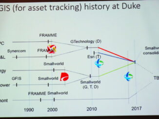
One of the challenges faced by large utilities with multiple GIS, outage management, customer information and other systems, which are often the result of mergers, is how to make spatial and associated data, in different, […]

3D data

High resolution satellite imagery helps innovative electric utility optimize vegetation management

5 February 2018 Geoff Zeiss

Vegetation is a significant source of outages for many utilities. In some regions from one quarter to one half of all outages can be ascribed to vegetation.  Vegetation encroachment initiated the massive North American northeastern […]

3D data

Electic power utility uses reality capture to rapidly develop grid data model

31 January 2018 Geoff Zeiss

Duquesne Light is typical of many of North American small to medium electric power utilities.  It does not have an outage management system  or an electrical data model which means it is difficult to connect customers […]

Between the Poles – The Geoff Zeiss Archives

Avoiding a repeat of the CAD/GIS quaqmire of the past quarter century

25 January 2018 Geoff Zeiss

Yesterday at Distributech 2018 in San Antonio I listened to a talk from a consulting company contracted by an electric power utility to clean up GIS data originally sourced from CAD drawings.  This reminded me […]

Between the Poles – The Geoff Zeiss Archives

Transactive energy is coming faster than we think

25 January 2018 Geoff Zeiss

At Distributech 2016 Zarko Sumic, Distinguished Analyst at Gartner, predicted that by 2020, the largest energy company in the world (by market cap) will not own any network (grid) or generation assets.  By analogy with […]

Between the Poles – The Geoff Zeiss Archives

U.S. grid reliability has not changed 2013-2016

24 January 2018 Geoff Zeiss

At Utility University at Distributech 2018 Joseph Nichols, a Project Manager at Burns and McDonnell, made the interesting case that over the period 2013 to 2016 there was a trend of increasing failure spend but […]

3D data

Top construction company AECOM applies BIM + geospatial for full lifecycle projects

18 January 2018 Geoff Zeiss

AECOM is a US$18.2 billion a year firm in the construction sector.  It designs and builds infrastructure around the world for public- and private-sector clients including transportation, facilities, environmental, energy, oil and gas, water, high-rise […]

3D data

An important role for national geospatial agencies: mapping underground infrastructure

17 January 2018 Geoff Zeiss

Since Google Earth’s release in June 2005, the rise of crowdsourced OpenStreetMap, the deluge of remote-sensed imagery from private satellite companies Digital Globe, Planet Labs, UrtheCast, and others, and private geospatial data companies like HERE, […]

Posts pagination

« 1 … 36 37 38 … 314 »

Events

Notice
There are no upcoming events.

View All Events

Services

  • Post a Job
  • Post an Ad
  • Post an Event
  • Post a Directory Listing
  • Post a Press Release
  • Media Kit
  • My Account
  • Login

Jobs

Post a Job
  • GIS Technologist II
    Fernie, B.C.
  • GIS I TECHNOLOGIST
    Fernie, B.C.
  • Civil Survey/ Engineering Technician (two positions available)
    Wolfville Nova Scotia
  • Survey Crew Chief
    Langley, BC
View All Jobs
  • Directories
    • Associations Directory
    • Industry Directory
    • Education Programs
    • Open Data
  • Volunteer
    • Start a GoGeomatics Group
    • Editors & Writers Group
  • About Us
    • GoGeomatics Media Kit
    • Who We Are
    • Contact Us
    • FAQ’s
    • Advertising
    • Marketing
  • Subscribe
GoGeomatics
GoGeomatics is the largest and most popular communications hub promoting the Canadian geospatial community. The business was incorporated in 2011. GoGeomatics hosts over 100 fun, free, location technology networking events each year in cities across Canada.

© 2026 GoGeomatics

  • facebook
  • Twitter
  • Linkedin
  • Youtube
  • Linkedin Group