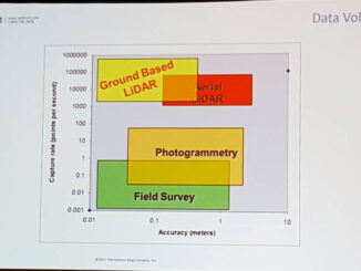
• facebook
  • Twitter
  • Linkedin
  • Youtube
  • Linkedin Group
  • Post a Job
  • Post an Ad
  • Post an Event
  • Post a Directory Listing
  • Post a Press Release
  • Media Kit
  • My Account
  • Login
GoGeomatics
  • MAGAZINE
    • BIM & GIS
    • Community
    • Conference news
    • Earth Observation
    • Education & Careers
    • GEOAI
    • Announcements
    • Reality Capture & Lidar
    • Science
    • Technology
    • Between the Poles
  • Directories
    • ASSOCIATION
    • INDUSTRY
    • EDUCATION
    • Open Data
  • EVENTS
    • GeoIgnite Events
    • Events Calendar
    • GoGeomatics Meetups
  • Services
    • Advertising
    • Marketing
    • Post a Job
    • Post an Ad
    • Post an Event
    • Post a Press Release
    • Post a Directory Listing
    • Media Kit
    • Web Design
  • Find a Job
  • Volunteer
    • Start a GoGeomatics Group
    • Editors & Writers Group
  • About Us
    • About Us
    • Contact Us
    • Frequently Asked Questions
  • Videos
HomeBetween the Poles – The Geoff Zeiss Archives

Between the Poles – The Geoff Zeiss Archives

3D data

Shortage of skilled trade workers drives prefabrication

14 November 2017 Geoff Zeiss

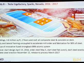
At the Fall BIMForum/BuildCon conference in Dallas two presentations about actual prefabrication experience – for data centres and for large automotive plants – both mentioned shortage of skilled labour as an important motivation for turning […]

3D data

HD BIM used to design Tesla Gigafactory in record time

8 November 2017 Geoff Zeiss

At the Fall BIMForum/BuildCon conference in Dallas, an entralling presentation about how HD BIM was used to build five buildings of the Tesla Gigafactory in Nevada in record time was given by Greg Luth of […]

Between the Poles – The Geoff Zeiss Archives

BIM LOD specification released under open Creative Commons license

8 November 2017 Geoff Zeiss

At the Fall BIMForum/BuildCon conference in Dallas, BIMForum announced the 2017 release of the Level of Development (LOD) specification.  The Level of Development (LOD) Specification is a reference that enables practitioners in the AEC Industry […]

Between the Poles – The Geoff Zeiss Archives

Satellite images used to track illegal fishing successfully used in court case

31 October 2017 Geoff Zeiss

Images from DigitalGlobe were used to track illegal fishing and provided evidence in court to support the seizure of a Thai vessel suspected of illegal fishing and labour abuses by the Indonesian Navy.  Indonesia has […]

3D data

Geocoordinated BIM modeling benefits build and operate projects

26 October 2017 Geoff Zeiss

Integrated BIM and geospatial modeling provide greater value to projects that involve not just design and construction but also operations and maintenance for an extended period after construction. At the Year in Infrastructure 2017 (YII2017) […]

Aging infrastructure

A conceptual design software tool for rail ?

16 October 2017 Geoff Zeiss

Software tools have become the standard for detailed design. Software has also made significant inroads into many aspects of construction. In contrast conceptual design still relies for the most part on “pencil and back of […]

3D data

Fully automated classification of road and highway features for autonomous vehicles

12 October 2017 Geoff Zeiss

Point clouds are fine for visualization to provide context, but to be really useful they need to be classified.  Feature extraction, as the process is often referred to,  is currently a mostly manual process that […]

Access to Spatial Data

Major expansion in shareability of project information in construction

11 October 2017 Geoff Zeiss

One of the challenges to the full expression of collaboration on construction projects is sharing information including geometry, properties, scans in the form of reality meshes, descriptions and status of equipment, and other information. In […]

Posts pagination

« 1 … 38 39 40 … 314 »

Events

Notice
There are no upcoming events.

View All Events

Services

  • Post a Job
  • Post an Ad
  • Post an Event
  • Post a Directory Listing
  • Post a Press Release
  • Media Kit
  • My Account
  • Login

Jobs

Post a Job
  • GIS Technologist II
    Fernie, B.C.
  • GIS I TECHNOLOGIST
    Fernie, B.C.
  • Civil Survey/ Engineering Technician (two positions available)
    Wolfville Nova Scotia
  • Survey Crew Chief
    Langley, BC
View All Jobs
  • Directories
    • Associations Directory
    • Industry Directory
    • Education Programs
    • Open Data
  • Volunteer
    • Start a GoGeomatics Group
    • Editors & Writers Group
  • About Us
    • GoGeomatics Media Kit
    • Who We Are
    • Contact Us
    • FAQ’s
    • Advertising
    • Marketing
  • Subscribe
GoGeomatics
GoGeomatics is the largest and most popular communications hub promoting the Canadian geospatial community. The business was incorporated in 2011. GoGeomatics hosts over 100 fun, free, location technology networking events each year in cities across Canada.

© 2026 GoGeomatics

  • facebook
  • Twitter
  • Linkedin
  • Youtube
  • Linkedin Group