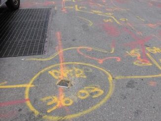
• facebook
  • Twitter
  • Linkedin
  • Youtube
  • Linkedin Group
  • Post a Job
  • Post an Ad
  • Post an Event
  • Post a Directory Listing
  • Post a Press Release
  • Media Kit
  • My Account
  • Login
GoGeomatics
  • MAGAZINE
    • BIM & GIS
    • Community
    • Conference news
    • Earth Observation
    • Education & Careers
    • GEOAI
    • Announcements
    • Reality Capture & Lidar
    • Science
    • Technology
    • Between the Poles
  • Directories
    • ASSOCIATION
    • INDUSTRY
    • EDUCATION
    • Open Data
  • EVENTS
    • GeoIgnite Events
    • Events Calendar
    • GoGeomatics Meetups
  • Services
    • Advertising
    • Marketing
    • Post a Job
    • Post an Ad
    • Post an Event
    • Post a Press Release
    • Post a Directory Listing
    • Media Kit
    • Web Design
  • Find a Job
  • Volunteer
    • Start a GoGeomatics Group
    • Editors & Writers Group
  • About Us
    • About Us
    • Contact Us
    • Frequently Asked Questions
  • Videos
HomeBetween the Poles – The Geoff Zeiss Archives

Between the Poles – The Geoff Zeiss Archives

Between the Poles – The Geoff Zeiss Archives

California legislation mandates reporting underground utility damage by excavators

27 April 2022 Geoff Zeiss

In 2016 in the first of several far reaching regulations the California legislature passed SB 661 that created the California Underground Facilities Safe Excavation Board. The primary activities of the board were to develop standards […]

Between the Poles – The Geoff Zeiss Archives

AGC one call survey: lack of accurate utility locating by network owners weakest element

14 April 2022 Geoff Zeiss

Recently the Associated General Contractors of America (AGC) conducted a survey of one call (811) underground utility safety and damage prevention processes among contractors in various construction sectors including heavy water/wastewater, highway/bridge, telecom, gas transmission […]

No Picture
Between the Poles – The Geoff Zeiss Archives

The National Underground Asset Register in the UK is holding a public consultation

11 April 2022 Geoff Zeiss

The Geospatial Commission is building a digital service for sharing data on the location of underground infrastructure – the National Underground Asset Register (NUAR). It is planned that NUAR will provide a consistent, digital map […]

Between the Poles – The Geoff Zeiss Archives

Is a national map of underground infrastructure achievable ?

4 April 2022 Geoff Zeiss

According to a recent report from the Next Practices Initiative of the Common Ground Alliance the damage prevention industry has reached an inflection point. For more than half a decade, the rate of damage to […]

Augmented reality

Reducing damage to underground utilities: the French DT DICT system

29 March 2022 Geoff Zeiss

In France a national system for reducing damage to underground utilities during construction was initiated in 2013.  The key features of the system are the requirement to notify utilities with the details of a proposed […]

No Picture
Between the Poles – The Geoff Zeiss Archives

Subsurface Utility Mapping Strategy Forum – Workshops March 24/25

22 March 2022 Geoff Zeiss

The Subsurface Utility Mapping Strategy Forum (SUMSF) workshops are free virtual sessions for individuals who want to delve deeper into technologies for locating and mapping underground infrastructure. The priority use cases are reducing damage to […]

Between the Poles – The Geoff Zeiss Archives

Effectiveness of different underground utility information policies in reducing utility damage during construction

21 March 2022 Geoff Zeiss

The primary objective of interventions relating to underground infrastructure is reducing damage to underground infrastructure during excavation. Different jurisdictions have implemented different schemes for reducing damage to underground infrastructure during construction. It is a well-known […]

Between the Poles – The Geoff Zeiss Archives

Subsurface Utility Mapping Strategy Forum – Speakers for Day 2 March 23

16 March 2022 Geoff Zeiss

The Subsurface Utility Mapping Strategy Forum (SUMSF), Mar 22-23, 2022 is a free virtual conference that brings together individuals and organizations to share information about and contribute to improving the mapping of underground infrastructure. The […]

Posts pagination

« 1 … 3 4 5 … 314 »

Events

May 25
May 25 - May 28

National Surveyors’ Conference 2026

May 27
May 27 @ 8:00 am - May 29 @ 5:00 pm

Canadian Cartographic Association Conference 2026

Jun 1
June 1 - June 4

CAG/CARTO Annual Meeting 2026

Jul 4
July 4 @ 8:00 am - July 11 @ 5:00 pm

ISPRS Congress 2026

Sep 15
September 15 - September 17

INTERGEO 2026

View Calendar

View All Events

Services

  • Post a Job
  • Post an Ad
  • Post an Event
  • Post a Directory Listing
  • Post a Press Release
  • Media Kit
  • My Account
  • Login

Jobs

Post a Job
  • GIS Technologist II
    Fernie, B.C.
  • GIS I TECHNOLOGIST
    Fernie, B.C.
  • Survey Crew Chief
    Langley, BC
  • Survey Tech
    Kamloops, BC
View All Jobs
  • Directories
    • Associations Directory
    • Industry Directory
    • Education Programs
    • Open Data
  • Volunteer
    • Start a GoGeomatics Group
    • Editors & Writers Group
  • About Us
    • GoGeomatics Media Kit
    • Who We Are
    • Contact Us
    • FAQ’s
    • Advertising
    • Marketing
  • Subscribe
GoGeomatics
GoGeomatics is the largest and most popular communications hub promoting the Canadian geospatial community. The business was incorporated in 2011. GoGeomatics hosts over 100 fun, free, location technology networking events each year in cities across Canada.

© 2026 GoGeomatics

  • facebook
  • Twitter
  • Linkedin
  • Youtube
  • Linkedin Group