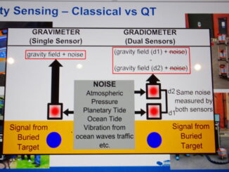
Many of the technologies for detecting underground utilities and other infrastructure involve shooting some type of signal, electromagnetic or acousic, into the ground and measuring the reflection off underground objects. A major challenge for these […]
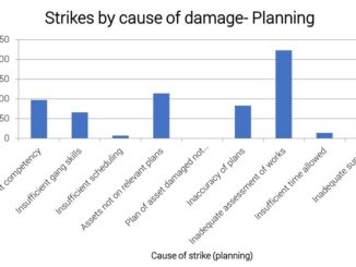
The Utility Strike Avoidance Group (USAG) has released its 2019 report on underground utility damage in the U.K. The analysis found that inadequate assessment of planned excavations in the pre-construction phase has grown significantly as […]
According to statistics compiled by the Common Ground Alliance (CGA) the process by which underground utilities are located (detected and marked) are responsible for 28% of incidents of damage to underground infrastructure during excavation. To […]
Knowing where things are underground has become important enough that in a number of jurisdictions around the world including the Netherlands, Singapore, and the U.K., initiatives are underway to create national digital twins which include […]
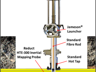
Inertial locating is an innovative technology that is used to accurately map underground pipe networks. But to date the technology has required non-pressurized pipes. Now a PHMSA-sponsored project has demonstrated that the technology can be […]
New regulations were released January 14 by the Colorado Department of Transportation (CDoT) that mandates (1) the electronic submission of high accuracy plans showing the location of of underground infrastructure prior to commencing a construction […]
Number of respondents: Contractors, statutory excavators, and roads authorities A survey of stakeholders in the construction industry has reported that respondents identified unreliable (inaccurate, incomplete) records as the biggest source of risk of damage to […]
Return on investment (ROI) studies of subsurface engineering utility engineering (SUE) surveys applied to highway construction projects conducted since the late 1990s have consistently revealed a large return-on-investment from conducting SUE surveys as part of […]
The vision of a single map showing all underground utilities and communications infrastructure is shared by many who are involved in planning, engineering and construction and those developing digital twins. But in many jurisdictions there […]
There are fundamental differences between above- and below-ground data which may limit the usefulness of underground data in digital twins. For location data about the underground there are often data quality issues, legal restrictions on […]
Estonia is well known as one of the most digital countries in Europe. At the GEOBIM 2020 conference this morning Christopher-Robin Raitviir, of the Estonian Department of Digital Construction in the Ministry of Economic Affairs […]
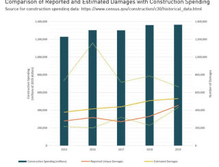
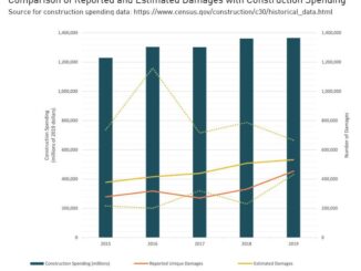
Blue bars – Construction spending ($millions). Red line – Reported unique damages. Yellow line – Estimated damages. Dotted lines – error bars. Source CGA 2020 DIRT Report The stated objectives of many initiatives focussed on […]
I was invited to participate in a meeting of the European Underground Infrastructure Community this morning. I heard about very important advances in capturing, capturing and sharing location information (maps) about underground infrastructure that are […]
Underground utilities and other infrastructure are a major cause of highway construction schedule and budget overruns. In addition to construction delays, damage to underground utilities during construction makes every construction project a potential disaster site […]
The primary objective of interventions such as one-call centres, pipeline safety and other regulations, and national programs such as ROADIC in Japan is the reduction of damage to underground infrastructure during excavation. Collecting reliable statistics […]
The recent PR19 comprehensive price review of the water industry by Ofwat, the economic regulator of the water sector in England and Wales has targeted an aggressive “reducing leakage by 15% within base costs” and […]
Uncertain knowledge about what lies under the surface is a major cause of delays and budget overruns on construction projects. It is well known that not knowing the location of utilities and other infrastructure is […]
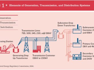
Last week the American Society of Civil Engineers (ASCE) released a new report in the Failure to Act series “Electric Infrastructure Investment Gaps in a Rapidly Changing Environment” that estimates the investment gap through 2039 […]
Last night, September 2 at 11:51 p.m. EDT at the Arianespace satellite launch base in Kourou, French Guiana (UTC-3) the VV16 mission launched 53 satellites, ranging in weight from 145 kg to 7 kg. Among […]
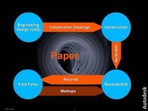
Most of underground utility damage during construction is attributable to incomplete, inaccurate and out of date records and network documentation. This data is the result of an inefficient, error-prone, and paper-based information flow from engineering, […]