• facebook
  • Twitter
  • Linkedin
  • Youtube
  • Linkedin Group
  • Post a Job
  • Post an Ad
  • Post an Event
  • Post a Directory Listing
  • Post a Press Release
  • Media Kit
  • My Account
  • Login
GoGeomatics
  • MAGAZINE
    • BIM & GIS
    • Community
    • Conference news
    • Earth Observation
    • Education & Careers
    • GEOAI
    • Announcements
    • Reality Capture & Lidar
    • Science
    • Technology
    • Between the Poles
  • Directories
    • ASSOCIATION
    • INDUSTRY
    • EDUCATION
    • Open Data
  • EVENTS
    • GeoIgnite Events
    • Events Calendar
    • GoGeomatics Meetups
  • Services
    • Advertising
    • Marketing
    • Post a Job
    • Post an Ad
    • Post an Event
    • Post a Press Release
    • Post a Directory Listing
    • Media Kit
    • Web Design
  • Find a Job
  • Volunteer
    • Start a GoGeomatics Group
    • Editors & Writers Group
  • About Us
    • About Us
    • Contact Us
    • Frequently Asked Questions
  • Videos
HomeBetween the Poles – The Geoff Zeiss Archives

Between the Poles – The Geoff Zeiss Archives

Between the Poles – The Geoff Zeiss Archives

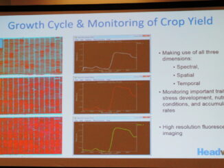
HxGN Live: Hyper-spectral camera mounted on a UAV for precision agriculture and other applications

28 June 2016 Geoff Zeiss

The typical multi-spectral camera used on satellites and airborne platforms captures three or four bands – typically the Landsat bands: green, red and near-infrared.   But hyperspectral cameras can capture 270 bands and are light […]

Between the Poles – The Geoff Zeiss Archives

Geo-enabling BIM workshop in London UK

28 June 2016 Geoff Zeiss

Following the Geo-enabling BIM Call to Action at Geo Business 2016, this is the next step. Survey4BIM – BIG5 Geospatial Challenges WorkshopFace to Face Round table event Wednesday 29th June 2016 Hear about the BIG […]

Between the Poles – The Geoff Zeiss Archives

Commercial satellite imaging market projected to reach $6.5 billion by 2023

27 June 2016 Geoff Zeiss

According to a recent report from Transparency Research “Commercial Satellite Imaging Market” which analyzes the global commercial satellite imaging market for the period 2013–2023, the global commercial satellite imaging market was valued at $2.5 billion […]

Between the Poles – The Geoff Zeiss Archives

Mapping urban underground utility infrastructure with GPR

27 June 2016 Geoff Zeiss

About three years ago at the GI_Forum Symposium in Salzburg, Paolo Viskanic of R3 GIS gave a presentation about a ground breaking project to map underground infrastructure that had been underway in the Region of Lombardy in Northern […]

No Picture
Access to Spatial Data

India proposes restricting access to geospatial data

22 June 2016 Geoff Zeiss

Some countries including Indonesia have passed legislation regulating geospatial data.   The intention appears to be to ensure a certain level of quality in geospatial data provided by private data providers to the public.  For example, […]

3D data

HxGN Live: 3D underground utility mapping, indoor mapping, UAVs and utility solutions

21 June 2016 Geoff Zeiss

Last week I had the opportunity to present at the annual Hexagon conference HxGN Live in Anaheim. Hexagon is a rapidly growing company with broad technology reach with core strengths in geospatial surveying and laser […]

Between the Poles – The Geoff Zeiss Archives

EIA Annual Energy Outlook 2016 projects nine to twelvefold growth in solar generation by 2040

17 June 2016 Geoff Zeiss

The U.S. Energy Information Administration (EIA) has issued a pre-release version of the Annual Energy Outlook 2016 (AEO2016).  The pre-release includes the Reference case and the No Clean Power Plan case.  The Reference case includes […]

3D cadastre

SPAR2016: Digitalizing highway construction at the Oregon DoT

8 June 2016 Geoff Zeiss

At SPAR 2013Ron Singh, Engineering Automation Manager/Chief of Surveys, Oregon Department of Transportation (DoT) made a startling proposal that would stand the traditional highway construction process on its head by making the post-construction as-built survey […]

Posts pagination

« 1 … 51 52 53 … 314 »

Events

Notice
There are no upcoming events.

View All Events

Services

  • Post a Job
  • Post an Ad
  • Post an Event
  • Post a Directory Listing
  • Post a Press Release
  • Media Kit
  • My Account
  • Login

Jobs

Post a Job
  • GIS Technologist II
    Fernie, B.C.
  • GIS I TECHNOLOGIST
    Fernie, B.C.
  • Civil Survey/ Engineering Technician (two positions available)
    Wolfville Nova Scotia
  • Survey Crew Chief
    Langley, BC
View All Jobs
  • Directories
    • Associations Directory
    • Industry Directory
    • Education Programs
    • Open Data
  • Volunteer
    • Start a GoGeomatics Group
    • Editors & Writers Group
  • About Us
    • GoGeomatics Media Kit
    • Who We Are
    • Contact Us
    • FAQ’s
    • Advertising
    • Marketing
  • Subscribe
GoGeomatics
GoGeomatics is the largest and most popular communications hub promoting the Canadian geospatial community. The business was incorporated in 2011. GoGeomatics hosts over 100 fun, free, location technology networking events each year in cities across Canada.

© 2026 GoGeomatics

  • facebook
  • Twitter
  • Linkedin
  • Youtube
  • Linkedin Group