• facebook
  • Twitter
  • Linkedin
  • Youtube
  • Linkedin Group
  • Post a Job
  • Post an Ad
  • Post an Event
  • Post a Directory Listing
  • Post a Press Release
  • Media Kit
  • My Account
  • Login
GoGeomatics
  • MAGAZINE
    • BIM & GIS
    • Community
    • Conference news
    • Earth Observation
    • Education & Careers
    • GEOAI
    • Announcements
    • Reality Capture & Lidar
    • Science
    • Technology
    • Between the Poles
  • Directories
    • ASSOCIATION
    • INDUSTRY
    • EDUCATION
    • Open Data
  • EVENTS
    • GeoIgnite Events
    • Events Calendar
    • GoGeomatics Meetups
  • Services
    • Advertising
    • Marketing
    • Post a Job
    • Post an Ad
    • Post an Event
    • Post a Press Release
    • Post a Directory Listing
    • Media Kit
    • Web Design
  • Find a Job
  • Volunteer
    • Start a GoGeomatics Group
    • Editors & Writers Group
  • About Us
    • About Us
    • Contact Us
    • Frequently Asked Questions
  • Videos
HomeBetween the Poles – The Geoff Zeiss Archives

Between the Poles – The Geoff Zeiss Archives

Access to Spatial Data

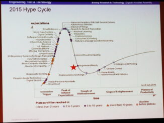
GeoBuiz 2016: High volume geospatial imagery processing requires new architecture

29 April 2016 Geoff Zeiss

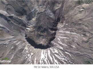
DigitalGlobe owns and operates a constellation of commercial earth observation satellites.  The latest is Worldview-3 which is capable of about 30 cm precision.  Digital Globe’s satellites collect 3,000,000 square kilometers of Earth imagery every day, […]

Between the Poles – The Geoff Zeiss Archives

GITA PNW: Maintaining high quality location data about underground infrastructure pays off

25 April 2016 Geoff Zeiss

At the 16th Annual GITA Pacific Northwest Conference, John Himmel, Manager GIS, at FortisBC Energy gave an overview of a remarkable geospatial solution that FortisBC will be deploying this summer.  It is a new online […]

No Picture
Between the Poles – The Geoff Zeiss Archives

GeoBuiz Summit April 26-27 includes construction, utilities, UAVs and cubesats

22 April 2016 Geoff Zeiss

GeoBuiz Summit is an innovative conference that brings together key industry innovators and leaders to discuss and share knowledge and experience about the evolving technology trends, market behavior, and business models in the geospatial community […]

Between the Poles – The Geoff Zeiss Archives

SGIP selected to lead Orange Button initiative

22 April 2016 Geoff Zeiss

The U.S. Department of Energy has announced $4 million for projects to launch the Orange Button℠ initiative.  To understand the financial risk of solar energy project development, the solar energy community relies on fragmented datasets […]

3D data

GITA PNW: Geolocating dangerous underground utility intersections is big business

22 April 2016 Geoff Zeiss

At the 16th Annual GITA Pacific Northwest Conference at the Boeing Future of Flight Museum in Mukilteo WA, David Steiger gave a fascinating presentation about one of the major problems arising from our poor knowledge […]

3D Visualization

SPAR2016: Augmented reality is finally going to happen, on smartphones

18 April 2016 Geoff Zeiss

I am back from two remarkable days at the Spar 3D Expo and Conference in Houston.  One thing that has stuck in my mind, because it is likely going to impact all of us, is […]

Asset management

SPAR 3D: Virtual reality, scan to BIM, infrastructure models, and mapping indoor spaces

14 April 2016 Geoff Zeiss

I have just experienced two remarkable days at the Spar 3D Expo and Conference in The Woodlands, Texas, in itself a remarkable location near Houston.  I will blog in more detail in the near future […]

No Picture
Between the Poles – The Geoff Zeiss Archives

Over $4 million awarded for fracking contaminated drinking water

13 April 2016 Geoff Zeiss

In the culmination of a court case running for seven years, a jury in Pennsylvania found that Cabot Oil & Gas Corporation had been negligent and had contaminated the drinking water of two families near […]

Posts pagination

« 1 … 55 56 57 … 314 »

Events

Notice
There are no upcoming events.

View All Events

Services

  • Post a Job
  • Post an Ad
  • Post an Event
  • Post a Directory Listing
  • Post a Press Release
  • Media Kit
  • My Account
  • Login

Jobs

Post a Job
  • GIS Technologist II
    Fernie, B.C.
  • GIS I TECHNOLOGIST
    Fernie, B.C.
  • Civil Survey/ Engineering Technician (two positions available)
    Wolfville Nova Scotia
  • Survey Crew Chief
    Langley, BC
View All Jobs
  • Directories
    • Associations Directory
    • Industry Directory
    • Education Programs
    • Open Data
  • Volunteer
    • Start a GoGeomatics Group
    • Editors & Writers Group
  • About Us
    • GoGeomatics Media Kit
    • Who We Are
    • Contact Us
    • FAQ’s
    • Advertising
    • Marketing
  • Subscribe
GoGeomatics
GoGeomatics is the largest and most popular communications hub promoting the Canadian geospatial community. The business was incorporated in 2011. GoGeomatics hosts over 100 fun, free, location technology networking events each year in cities across Canada.

© 2026 GoGeomatics

  • facebook
  • Twitter
  • Linkedin
  • Youtube
  • Linkedin Group