• facebook
  • Twitter
  • Linkedin
  • Youtube
  • Linkedin Group
  • Post a Job
  • Post an Ad
  • Post an Event
  • Post a Directory Listing
  • Post a Press Release
  • Media Kit
  • My Account
  • Login
GoGeomatics
  • MAGAZINE
    • BIM & GIS
    • Community
    • Conference news
    • Earth Observation
    • Education & Careers
    • GEOAI
    • Announcements
    • Reality Capture & Lidar
    • Science
    • Technology
    • Between the Poles
  • Directories
    • ASSOCIATION
    • INDUSTRY
    • EDUCATION
    • Open Data
  • EVENTS
    • GeoIgnite Events
    • Events Calendar
    • GoGeomatics Meetups
  • Services
    • Advertising
    • Marketing
    • Post a Job
    • Post an Ad
    • Post an Event
    • Post a Press Release
    • Post a Directory Listing
    • Media Kit
    • Web Design
  • Find a Job
  • Volunteer
    • Start a GoGeomatics Group
    • Editors & Writers Group
  • About Us
    • About Us
    • Contact Us
    • Frequently Asked Questions
  • Videos
HomeBetween the Poles – The Geoff Zeiss Archives

Between the Poles – The Geoff Zeiss Archives

Total articles: 2505

3D data

Study shows augmented reality improves productivity of underground utility locators

4 August 2020 Geoff Zeiss

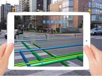
Mixed reality applications for visualizing underground utilities in 3D have been available from many companies for years, but have not been widely used. There are signs this is changing. For example, vGIS is an augmented […]

Read more

Between the Poles – The Geoff Zeiss Archives

Nanosatellites and drones represent a paradigm shift in measurement of methane emissions

30 July 2020 Geoff Zeiss

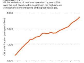
Annual emissions of methane (CH4) have risen by almost 10% in the past two decades. The primary sources of methane are the oil and gas industry and agriculture, in large part from livestock.  Methane emissions […]

Read more

Between the Poles – The Geoff Zeiss Archives

New satellite constellation will capture 30 cm imagery with up to 15 revisits per day

23 July 2020 Geoff Zeiss

I remember back in August 2014, when the first images from WorldView-3 were being downloaded. WorldView-3 was the first one-foot-resolution commercial satellite. It operated at an altitude of 617 km, flew in a sun synchronous […]

Read more

3D data

Innovative technology uses AM radio waves to detect underground infrastructure

21 July 2020 Geoff Zeiss

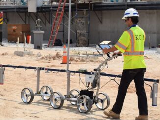
In the last few years there have been important advances in technology for detecting underground infrastructure including capturing ground penetrating radar (GPR) scans at highway speeds, combined GPR and LiDAR scanning for simultaneous above and […]

Read more

Between the Poles – The Geoff Zeiss Archives

Geospatial+BIM are a major contributor transforming construction

17 July 2020 Geoff Zeiss

Geospatial and BIM have been identified as key technologies in the digital transformation of the global construction sector which has been underperforming for decades.  A recent report estimates the size of the contribution of geospatial+BIM […]

Read more

Between the Poles – The Geoff Zeiss Archives

New standard for capturing information about underground utilities exposed during construction

8 July 2020 Geoff Zeiss

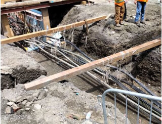
In Germany a new standard for documenting and exchanging information about underground infrastructure exposed during construction has been developed. Referred to as DIN SPEC 91419 it provides a standardized way to capture and share a […]

Read more

3D data

Above and underground infrastructure comprise Rotterdam’s open digital twin

6 July 2020 Geoff Zeiss

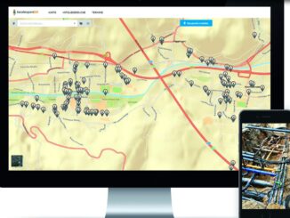
The City of Rotterdam is developing a digital twin of the city.  3D vector and image data of the above- and underground infrastructure, zoning regulations and city by-laws, data streams from real-time sensors, applications and […]

Read more

Between the Poles – The Geoff Zeiss Archives

Using satellite imagery to prioritize vegetation management for utilities

25 June 2020 Geoff Zeiss

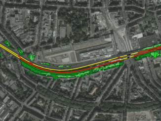
A recent startup LiveEO is focusing on the digitalization of energy and transportation network assets using satellite imagery. LiveEO uses current multi-band imagery including radar and hyperspectral data at various resolutions from earth observation satellites […]

Read more

Between the Poles – The Geoff Zeiss Archives

Scotland’s system for sharing location information about underground infrastructure to be mandatory

23 June 2020 Geoff Zeiss

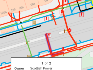
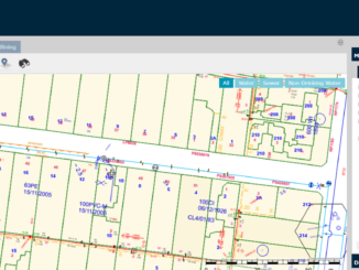
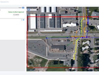
Scotland is one of the leading jurisdictions in developing a nation-wide collaborative system for sharing information about the location of underground infrastructure among stakeholders involved in road construction including roads authorities, utility and telecom network […]

Read more

Between the Poles – The Geoff Zeiss Archives

Collaboration key to success of U.K. National Underground Asset Register pilots

22 June 2020 Geoff Zeiss

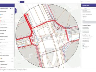
At a Digital Leaders Virtual event Heath Pritchard, Maria Teneke, Holger Kessler and Neil Brammall of the National Underground Asset Register (NUAR) project reported on the progress to date of one of the Geospatial Commission’s […]

Read more

Between the Poles – The Geoff Zeiss Archives

Digitally capturing the location of underground utilities detected using electromagnetic techniques

16 June 2020 Geoff Zeiss

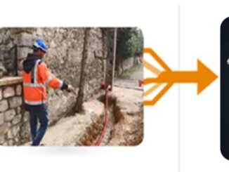
The industry standard for locating underground utilities is a manual process involving the use of an electromagnetic (EM) wand to detect underground cables and pipes.  The detected location is typically recorded by painting or otherwise […]

Read more

Between the Poles – The Geoff Zeiss Archives

Survey delineates subsurface utility engineering (SUE) adoption in Canada

15 June 2020 Geoff Zeiss

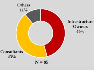
The Centre for Advancement of Trenchless Technologies(CATT) has just released the report of a survey designed to better understand the current state of subsurface utility engineering (SUE) practices, barriers, and acceptance across Canada.  The most […]

Read more

3D data

Using statistical averaging to increase depth of penetration for ground penetrating radar

10 June 2020 Geoff Zeiss

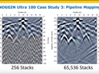
Recently Greg Johnston of Sensors and Software gave a very informative webinar on the factors that limit the depth to which ground penetrating radar (GPR) is effective in detecting objects.  Greg showed how statistical averaging […]

Read more

3D data

White paper on reducing damage to underground utilities during construction

2 June 2020 Geoff Zeiss

It is estimated that unreliable location information about underground infrastructure represents a $50 billion drag on the U.S. economy. Comparing the United States and Japan reveals a startling difference in the annual incidents of underground […]

Read more

Between the Poles – The Geoff Zeiss Archives

Australian water utility provides open access to water and wastewater network location data

19 May 2020 Geoff Zeiss

Open data has become a goal for many governments, but is relatively rare among utility and telecom network operators and owners.  In Australia several water and wastewater network operators have made the location of their […]

Read more

3D data

Montana mandates the submission of accurate electronic as-builts by utility owners

13 May 2020 Geoff Zeiss

Montana has recently revised its statutes governing the installation of utilities on state highway right-of-ways. The revised statutes require Administrative Rules regarding utility occupancy on state highway right-of-ways. The updated Administrative Rules mandate that as […]

Read more

3D data

Centimetre-accurate as-builts efficiently captured with a smartphone

7 May 2020 Geoff Zeiss

Without accurate maps of underground infrastructure, every construction project has the potential to become a disaster site. Incidents of underground utility damage are more frequent than many people realize. In the U.S. there are between […]

Read more

Analytics

Automated drone systems improve power line inspections and reduce costs

5 May 2020 Geoff Zeiss

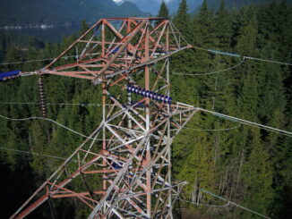
Transmission line inspections are mandatory in North America. Traditionally helicopters are used for these inspections, but with helicopters the risk of accidents is significant and helicopters are costly to maintain and operate.  Drone inspections dramatically […]

Read more

3D data

Initiative to develop open standards for AEC and geospatial interoperability

30 April 2020 Geoff Zeiss

The effects of population growth, urbanization and climate change are motivating us to contemplate serious changes in how we build and maintain buildings and infrastructure. This change will require new tools. There are important industry […]

Read more

3D data

Augmented reality enables simplified design workflows

21 April 2020 Geoff Zeiss

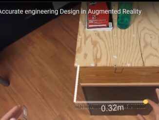
Engineering design is typically done on a desktop computer, using CAD or BIM software. Models are viewed in 3D or 2D on a monitor. Increasingly they can be viewed in mixed reality.  At a SPAR3D […]

Read more

Posts pagination

« 1 … 5 6 7 … 126 »

Events

Notice
There are no upcoming events.

View All Events

Services

  • Post a Job
  • Post an Ad
  • Post an Event
  • Post a Directory Listing
  • Post a Press Release
  • Media Kit
  • My Account
  • Login

Jobs

Post a Job
  • Geospatial Analytical Technician / Technicien, analyses géospatiales; technicienne, analyses géospatiales
    Peterborough
  • GIS Technologist II
    Fernie, B.C.
  • GIS I TECHNOLOGIST
    Fernie, B.C.
  • Hydrogeologist
    Calgary, Alberta
View All Jobs
  • Directories
    • Associations Directory
    • Industry Directory
    • Education Programs
    • Open Data
  • Volunteer
    • Start a GoGeomatics Group
    • Editors & Writers Group
  • About Us
    • GoGeomatics Media Kit
    • Who We Are
    • Contact Us
    • FAQ’s
    • Advertising
    • Marketing
  • Subscribe
GoGeomatics
GoGeomatics is the largest and most popular communications hub promoting the Canadian geospatial community. The business was incorporated in 2011. GoGeomatics hosts over 100 fun, free, location technology networking events each year in cities across Canada.

© 2026 GoGeomatics

  • facebook
  • Twitter
  • Linkedin
  • Youtube
  • Linkedin Group