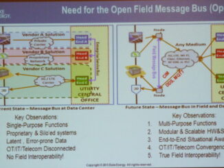
• facebook
  • Twitter
  • Linkedin
  • Youtube
  • Linkedin Group
  • Post a Job
  • Post an Ad
  • Post an Event
  • Post a Directory Listing
  • Post a Press Release
  • Media Kit
  • My Account
  • Login
GoGeomatics
  • MAGAZINE
    • BIM & GIS
    • Community
    • Conference news
    • Earth Observation
    • Education & Careers
    • GEOAI
    • Announcements
    • Reality Capture & Lidar
    • Science
    • Technology
    • Between the Poles
  • Directories
    • ASSOCIATION
    • INDUSTRY
    • EDUCATION
    • Open Data
  • EVENTS
    • GeoIgnite Events
    • Events Calendar
    • GoGeomatics Meetups
  • Services
    • Advertising
    • Marketing
    • Post a Job
    • Post an Ad
    • Post an Event
    • Post a Press Release
    • Post a Directory Listing
    • Media Kit
    • Web Design
  • Find a Job
  • Volunteer
    • Start a GoGeomatics Group
    • Editors & Writers Group
  • About Us
    • About Us
    • Contact Us
    • Frequently Asked Questions
  • Videos
HomeBetween the Poles – The Geoff Zeiss Archives

Between the Poles – The Geoff Zeiss Archives

3D data

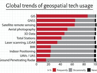
Convergence of BIM and geospatial contributes to better management of information

2 March 2015 Geoff Zeiss

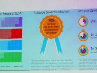
Dr Anne Kemp, Director and Fellow, Atkins, Vice-Chair of BuildingSmart, UK, Chair of ICE BIM Action Group, and Chair of BIM4Infrastructure UK, has published very thought-provoking insights into how the convergence of BIM and geospatial […]

Between the Poles – The Geoff Zeiss Archives

US FAA proposes lenient rules for non-recreational small unmanned aircraft operation

20 February 2015 Geoff Zeiss

In general the operation of unmanned aerial vehicles (UAV) for commercial purposes is illegal in the U.S.  But in the last few months the Federal Aviation Administration has issued grants of exemption to six companies […]

Between the Poles – The Geoff Zeiss Archives

State of BIM delivery in the UK one year before government mandate

19 February 2015 Geoff Zeiss

One of the highlights of this this year’s RICS BIM Conference in London was the keynote presentation Delivery of Level 2 BIM by Terry Stocks, Deputy Head of Estates Department, Ministry of Justice and  Delivery […]

Between the Poles – The Geoff Zeiss Archives

Interoperability leading factor determining geospatial software purchasing decisions

17 February 2015 Geoff Zeiss

Geospatial World has just published the results of a survey of 650 of its readers conducted between November 2014 and January 2015 targeted on their geospatial technology and data usage.  Geospatial softwarion One of the […]

3D data

Latest survey suggests rapid adoption of new geospatial technology in Asia/Pacific

16 February 2015 Geoff Zeiss

Geospatial World has just published the results of a survey of 650 of its readers conducted between November 2014 and January 2015 targeted on their geospatial technology usage.  Geospatial technologies The geospatial technologies respondents were […]

3D stereoscopic imagery

Reducing energy consumption of buildings

15 February 2015 Geoff Zeiss

According to the IEA’s Energy Technology Perspectives 2014, global growth in electricity demand exceeds all other final energy carriers.  Since the 1970s,  electricity’s share of total energy demand has grown from 9% to over 17%.   […]

No Picture
3D data

Deriving engineering and O&M cost information from “scan to BIM” models

14 February 2015 Geoff Zeiss

At last year’s Royal Institution of Chartered Surveyors (RICS) BIM National Conference 2014, RICS sponsored a BIM Vendor Showcase in which a BIM model derived from scanning the RICS headquarters building in Parliament Sq in […]

Between the Poles – The Geoff Zeiss Archives

Open distributed intelligence platform for microgrids with solar and battery storage

9 February 2015 Geoff Zeiss

At DistribuTECH 2015, Duke Energy held a session about their Phase 2 project (COW II) of the Coalition of the Willing initiative. Stuart Laval, Smart Grid Technology Manager at Duke, presented an overview of the COW II […]

Posts pagination

« 1 … 64 65 66 … 314 »

Events

Notice
There are no upcoming events.

View All Events

Services

  • Post a Job
  • Post an Ad
  • Post an Event
  • Post a Directory Listing
  • Post a Press Release
  • Media Kit
  • My Account
  • Login

Jobs

Post a Job
  • GIS Technologist II
    Fernie, B.C.
  • GIS I TECHNOLOGIST
    Fernie, B.C.
  • Civil Survey/ Engineering Technician (two positions available)
    Wolfville Nova Scotia
  • Survey Crew Chief
    Langley, BC
View All Jobs
  • Directories
    • Associations Directory
    • Industry Directory
    • Education Programs
    • Open Data
  • Volunteer
    • Start a GoGeomatics Group
    • Editors & Writers Group
  • About Us
    • GoGeomatics Media Kit
    • Who We Are
    • Contact Us
    • FAQ’s
    • Advertising
    • Marketing
  • Subscribe
GoGeomatics
GoGeomatics is the largest and most popular communications hub promoting the Canadian geospatial community. The business was incorporated in 2011. GoGeomatics hosts over 100 fun, free, location technology networking events each year in cities across Canada.

© 2026 GoGeomatics

  • facebook
  • Twitter
  • Linkedin
  • Youtube
  • Linkedin Group