• facebook
  • Twitter
  • Linkedin
  • Youtube
  • Linkedin Group
  • Post a Job
  • Post an Ad
  • Post an Event
  • Post a Directory Listing
  • Post a Press Release
  • Media Kit
  • My Account
  • Login
GoGeomatics
  • MAGAZINE
    • BIM & GIS
    • Community
    • Conference news
    • Earth Observation
    • Education & Careers
    • GEOAI
    • Announcements
    • Reality Capture & Lidar
    • Science
    • Technology
    • Between the Poles
  • Directories
    • ASSOCIATION
    • INDUSTRY
    • EDUCATION
    • Open Data
  • EVENTS
    • GeoIgnite Events
    • Events Calendar
    • GoGeomatics Meetups
  • Services
    • Advertising
    • Marketing
    • Post a Job
    • Post an Ad
    • Post an Event
    • Post a Press Release
    • Post a Directory Listing
    • Media Kit
    • Web Design
  • Find a Job
  • Volunteer
    • Start a GoGeomatics Group
    • Editors & Writers Group
  • About Us
    • About Us
    • Contact Us
    • Frequently Asked Questions
  • Videos
HomeBetween the Poles – The Geoff Zeiss Archives

Between the Poles – The Geoff Zeiss Archives

Total articles: 2505

No Picture
Between the Poles – The Geoff Zeiss Archives

Cost of underground utility damage represents a major drag on national economies

14 April 2020 Geoff Zeiss

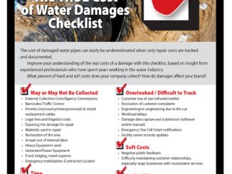
Underground utility damage is expensive. Several jurisdictions have attempted to estimate the cost of underground utility damage for individual incidents and for entire national economies. Costs can be broken down into direct costs and indirect […]

Read more

3D data

Acoustic location works where EM and GPR techniques don’t for locating underground infrastructure

9 April 2020 Geoff Zeiss

There have been significant advances in technologies for detecting underground infrastructure including inertial locating, novel radar technologies applied to ground penetrating radar (GPR), and software for post processing GPR signals to produce tomographic images. Each […]

Read more

Between the Poles – The Geoff Zeiss Archives

Hybrid GIS and survey system tackles low quality underground utility location information

7 April 2020 Geoff Zeiss

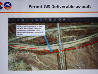
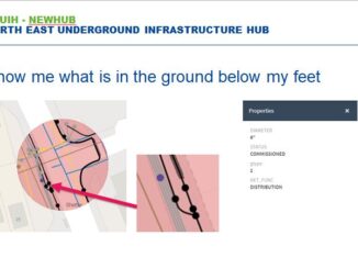
At the fourth Digital Underground Connect (DUConnect) session, Rob Martindale, Utility Program Manager at the Colorado Department of Transportation (CDOT) provided an overview of a remarkable initiative by the State of Colorado to address the […]

Read more

Between the Poles – The Geoff Zeiss Archives

The role of surveyors in locating and mapping underground utilities

6 April 2020 Geoff Zeiss

Accurately mapping underground utility and telecom network assets represents a growing opportunity for professional surveyors. In order to ensure continuing improvement in the accuracy of location information about underground utilities, some international jurisdictions are requiring […]

Read more

3D data

Practical benefits of accurate mapping of underground utilities for construction projects

31 March 2020 Geoff Zeiss

Government agencies and construction firms are recognizing the significant benefits of an accurate map of underground infrastructure for construction projects. Here we describe how accurate models of underground infrastructure bring practical benefits to construction projects. […]

Read more

Between the Poles – The Geoff Zeiss Archives

Comprehensive approach essential for reducing underground utility damage during construction

26 March 2020 Geoff Zeiss

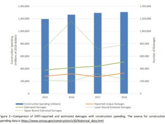
Comparing the United States and Japan reveals a startling difference in the number of incidents of underground utility damage during construction. In the U.S. the number of incidents is between 400,000 and 800,000 per year […]

Read more

No Picture
Between the Poles – The Geoff Zeiss Archives

Large ROI from subsurface utility engineering (SUE) for highway construction projects

16 March 2020 Geoff Zeiss

Return on investment (ROI) studies of subsurface engineering utility engineering (SUE) surveys applied to highway construction projects conducted since the late 1990s have consistently revealed a large return-on-investment from conducting SUE surveys as part of […]

Read more

No Picture
Between the Poles – The Geoff Zeiss Archives

ROI of $11.39 for every $1 spent on subsurface utility engineering on highway construction projects

10 March 2020 Geoff Zeiss

A definitive study of twenty-two projects utilizing subsurface utility engineering (SUE) and eight non-SUE projects from Pennsylvania Department of Transportation (PennDOT) districts has revealed that $11.39 can be saved for every $1 spent on SUE.  […]

Read more

3D data

Revision to PAS 128 standard for locating underground utilities available for public comment

3 March 2020 Geoff Zeiss

A revision to the PAS 128 2014 standard for locating underground utilities is available for public comment through March 16. PAS 128 defines a hierarchy of detection methods for detecting underground utilities in terms and […]

Read more

No Picture
3D data

New ASCE standard guideline for recording and exchanging utility infrastructure data is imminent

2 March 2020 Geoff Zeiss

The release of the new ASCE Standard Guideline for Recording and Exchanging Utility Infrastructure Data (also referred to as the utility as-built standard) developed under the auspices of the American Society of Civil Engineers (ASCE’s) […]

Read more

Between the Poles – The Geoff Zeiss Archives

Mapping gas flowline and gathering system infrastructure mandatory in Colorado

26 February 2020 Geoff Zeiss

There are nearly a million natural gas and oil wells in the United States, most of which have used fracking to release natural gas and tight oil from underground geological strata.  To gather and collect […]

Read more

Between the Poles – The Geoff Zeiss Archives

Damage to underground infrastructure during construction increasing in Ontario

24 February 2020 Geoff Zeiss

Statistics on incidents of underground utility damage from the Ontario Regional Common Ground Alliance (ORCGA) 2018 DIRT report reveals a trend since 2014 of increasing utility damage suggesting that new measures are required to drive […]

Read more

Access to Spatial Data

Federal initiatives in Canada to improve subsurface locating to reduce damage during construction

18 February 2020 Geoff Zeiss

A remarkable initiative within the Federal government in Canada to improve mapping of Federally regulated underground infrastructure and infrastructure on Federal lands was presented at the Ontario Regional Common Ground Alliance (ORCGA) 2020 Symposium in […]

Read more

Between the Poles – The Geoff Zeiss Archives

Comprehensive checklist of direct and indirect costs of damage to underground infrastructure

17 February 2020 Geoff Zeiss

I have blogged previously about research at the University of Birmingham in the U.K. that found that the indirect and social cost of underground utility damage was 29 X the direct cost.  At the Ontario […]

Read more

3D data

Automating scan-to-BIM for brownfield substations

6 February 2020 Geoff Zeiss

With about 55,000 substations in the U.S. and the average age of the transformers in these substations over 40 years old, many substations are going to be refurbished, retrofitted, extended or upgraded. Utilities are opting […]

Read more

Between the Poles – The Geoff Zeiss Archives

UK pilots demonstrate secure platform for sharing information about underground utility networks

16 January 2020 Geoff Zeiss

In the 2017 autumn budget the Chancellor of the Exchequer announced an important initiative to increase the value of the contribution of spatial data to the UK economy. The Geospatial Commission was created in the […]

Read more

No Picture
Between the Poles – The Geoff Zeiss Archives

Remarkably low incidence of underground utility damage in Japan

20 December 2019 Geoff Zeiss

In the U.S. in 2017 there were 316,422 incidents of damage to underground infrastructure reported to the Common Ground Alliance in 2017.  In the Netherlands in 2018 there were 41,169 incidents.  Remarkably the number I […]

Read more

Asset management

Elements for improving underground utility mapping to reduce risk of damage during construction

16 December 2019 Geoff Zeiss

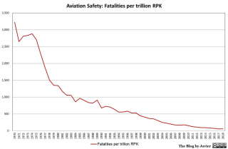
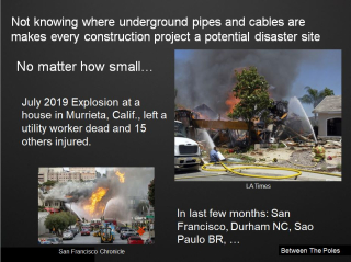
Without accurate maps of underground infrastructure, every construction project has the potential to become a disaster site. Unlike the aviation industry where reliable data is collected and is accessible to investigators to prevent disasters from […]

Read more

3D data

Inertial mapping of underground pipe networks

10 December 2019 Geoff Zeiss

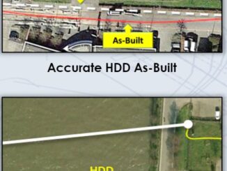
Currently best practices for recording the location of new underground infrastructure is to survey it after installation and before covering the trench. Appropriate survey tools are total stations, RTK, and LiDAR.  However, trenchless technology is […]

Read more

Between the Poles – The Geoff Zeiss Archives

Locate issues are a major cause of underground utility damage/strikes in U.S. and U.K.

9 December 2019 Geoff Zeiss

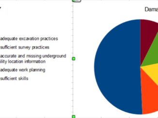
In the U.S. and the U.K. statistics reveal that about a quarter of underground utility damage and strikes is attributable to locating issues including inaccurate maps, missing data and problems with underground locating equipment. There […]

Read more

Posts pagination

« 1 … 6 7 8 … 126 »

Events

Notice
There are no upcoming events.

View All Events

Services

  • Post a Job
  • Post an Ad
  • Post an Event
  • Post a Directory Listing
  • Post a Press Release
  • Media Kit
  • My Account
  • Login

Jobs

Post a Job
  • Geospatial Analytical Technician / Technicien, analyses géospatiales; technicienne, analyses géospatiales
    Peterborough
  • GIS Technologist II
    Fernie, B.C.
  • GIS I TECHNOLOGIST
    Fernie, B.C.
  • Hydrogeologist
    Calgary, Alberta
View All Jobs
  • Directories
    • Associations Directory
    • Industry Directory
    • Education Programs
    • Open Data
  • Volunteer
    • Start a GoGeomatics Group
    • Editors & Writers Group
  • About Us
    • GoGeomatics Media Kit
    • Who We Are
    • Contact Us
    • FAQ’s
    • Advertising
    • Marketing
  • Subscribe
GoGeomatics
GoGeomatics is the largest and most popular communications hub promoting the Canadian geospatial community. The business was incorporated in 2011. GoGeomatics hosts over 100 fun, free, location technology networking events each year in cities across Canada.

© 2026 GoGeomatics

  • facebook
  • Twitter
  • Linkedin
  • Youtube
  • Linkedin Group