• facebook
  • Twitter
  • Linkedin
  • Youtube
  • Linkedin Group
  • Post a Job
  • Post an Ad
  • Post an Event
  • Post a Directory Listing
  • Post a Press Release
  • Media Kit
  • My Account
  • Login
GoGeomatics
  • MAGAZINE
    • BIM & GIS
    • Community
    • Conference news
    • Earth Observation
    • Education & Careers
    • GEOAI
    • Announcements
    • Reality Capture & Lidar
    • Science
    • Technology
    • Between the Poles
  • Directories
    • ASSOCIATION
    • INDUSTRY
    • EDUCATION
    • Open Data
  • EVENTS
    • GeoIgnite Events
    • Events Calendar
    • GoGeomatics Meetups
  • Services
    • Advertising
    • Marketing
    • Post a Job
    • Post an Ad
    • Post an Event
    • Post a Press Release
    • Post a Directory Listing
    • Media Kit
    • Web Design
  • Find a Job
  • Volunteer
    • Start a GoGeomatics Group
    • Editors & Writers Group
  • About Us
    • About Us
    • Contact Us
    • Frequently Asked Questions
  • Videos
HomeBetween the Poles – The Geoff Zeiss Archives

Between the Poles – The Geoff Zeiss Archives

3D data

Increasing penetration of open source geospatial software in the global utility GIS market

8 July 2014 Geoff Zeiss

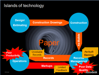
Improving process efficiency (also here, here, here and here) is a major challenge for the utility industry.  Geospatial technology is a key technology that helps utilities improve the efficiency of their business processes (such as designing-constructing-maintaining and operating their […]

Between the Poles – The Geoff Zeiss Archives

Well-funded cyberespionage attack targets energy sector

5 July 2014 Geoff Zeiss

A cyberespionage attack, identified by Symantec as Dragonfly, has targeted energy grid operators, major electricity generation firms, petroleum pipeline operators, and energy industry industrial equipment providers located primarily in the United States, Spain, France, Italy, […]

Between the Poles – The Geoff Zeiss Archives

Reducing power consumption of networked devices in standby could save 600 TWh of energy

4 July 2014 Geoff Zeiss

According to the International Energy Agency (IEA) in 2013, the world’s networked devices such as set-top boxes, modems, printers and game consoles consumed around 616 terawatt hours (TWh) of electricity.  Of this total most of […]

Between the Poles – The Geoff Zeiss Archives

Call for presentations for inaugural OGC Academic Summit 2014 issued by Open Geospatial Consortium

3 July 2014 Geoff Zeiss

The Open Geospatial Consortium (OGC) has issued a call for presentations at the inaugural OGC Academic Summit 2014 to be held 15-16 September 2014 at the University of Calgary in Alberta, Canada.  Presentations should be […]

Between the Poles – The Geoff Zeiss Archives

NASA’s first dedicated satellite to study atmospheric carbon dioxide launched

2 July 2014 Geoff Zeiss

July 2, 2014 at 2:56 AM the Orbiting Carbon Observatory-2 (OCO-2), NASA’s first dedicated Earth remote sensing satellite to study atmospheric carbon dioxide from Space. was launched on a Delta rocket. OCO-2 will be collecting […]

3D data

Open standards-based foundation for integrating BIM, geospatial and smart meters for urban energy performance optimization

1 July 2014 Geoff Zeiss

The European Union has set itself aggressive goals to reduce GHG emissions by 20%, increase renewables share of energy generation to 20%, and to reduce energy consumption by 20% by 2020.  The EU seems to […]

Between the Poles – The Geoff Zeiss Archives

India’s Prime Minister affirms importance of GIS

30 June 2014 Geoff Zeiss

“GIS (Geographic Information Systems) has applications in urban planning and watershed development. Space imagery helps in land management, coastal management. It is an invaluable asset in disaster management.” said Prime Minister Modi on the occasion […]

Between the Poles – The Geoff Zeiss Archives

Joint INSPIRE and Geospatial World Forum Conference announced for 24-29 May 2015 in Lisbon, Portugal

28 June 2014 Geoff Zeiss

INSPIRE is based on the infrastructures for spatial information established and operated by the 27 Member States of the European Union. The Directive addresses 34 spatial data themes needed for environmental applications, with key components […]

Posts pagination

« 1 … 74 75 76 … 314 »

Events

Notice
There are no upcoming events.

View All Events

Services

  • Post a Job
  • Post an Ad
  • Post an Event
  • Post a Directory Listing
  • Post a Press Release
  • Media Kit
  • My Account
  • Login

Jobs

Post a Job
  • GIS Technologist II
    Fernie, B.C.
  • GIS I TECHNOLOGIST
    Fernie, B.C.
  • Civil Survey/ Engineering Technician (two positions available)
    Wolfville Nova Scotia
  • Survey Crew Chief
    Langley, BC
View All Jobs
  • Directories
    • Associations Directory
    • Industry Directory
    • Education Programs
    • Open Data
  • Volunteer
    • Start a GoGeomatics Group
    • Editors & Writers Group
  • About Us
    • GoGeomatics Media Kit
    • Who We Are
    • Contact Us
    • FAQ’s
    • Advertising
    • Marketing
  • Subscribe
GoGeomatics
GoGeomatics is the largest and most popular communications hub promoting the Canadian geospatial community. The business was incorporated in 2011. GoGeomatics hosts over 100 fun, free, location technology networking events each year in cities across Canada.

© 2026 GoGeomatics

  • facebook
  • Twitter
  • Linkedin
  • Youtube
  • Linkedin Group