
One of the areas that researchers involved in the INSPIRE initiative are putting a lot of effort these days is quantifying the business benefits of an open spatial data infrastructure. At the recent INSPIRE conference in Krakow Max Craglia outlined the results of studies in the EU that attempted to quantify the economic benefits of sharing spatial data. Seven years ago it was estimated that the benefits outweighed the costs by a factor of about 6 or 7. Since then, some concrete data has begun to provide more reliable estimates. One recent concrete quantified result was the reduction across the EU of the cost of environmental impact assessments (EIA) and strategic environmental assessments (SEA). About 20 000 of these are undertaken each year. They require about six months and cost about €75 000. It has been estimated that 5% of the cost and 8-10% of the time required to prepare these assessments was devoted to finding the requisite data. If as a result of INSPIRE, the data was readily available, then these costs would not be incurred and the result would be savings of €100 to €200 million across the EU.
A more concrete study was undertaken in Catalonia where an investment in standards-based spatial data infrastructure (SDI) of €1.5 million over the four year period 2002-2006, realized efficiency savings of 500 hours per month, equivalent to about €2.6 million for the entire period. In addition local government in Catalonia estimated an effectiveness savings of 480 hours per month. An important wider social benefit was narrowing the digital gap between larger and smaller municipalities, which meant that as a result of INSPIRE, smaller municipalities were able to offer their residents services that had previously been only available in larger centres.
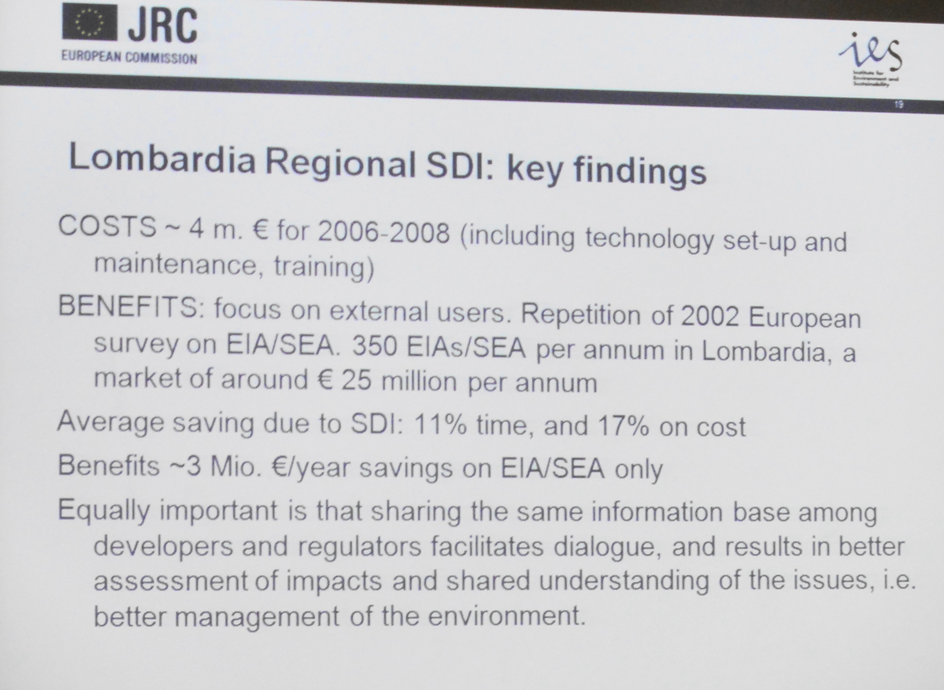 A second study was reported from Lombardia where an expenditure of about €4 million over the period 2006 to 2008 improved the efficiency of EIA and SEA production. About 350 EIAs and SEAs are prepared every year in Lombardia at a total cost of about €25 million annually. It was concluded that the regional SDI resulted in time savings of 11% and cost savings of 17%, which reduced the cost of preparing EIAs and SEAs by €3 million annually.
At the INSPIRE conference I bumped into Steven Ramage, the new Executive Director for Marketing and Communications at the Open Geospatial Consortium (OGC). During our conversation he pointed out that he is running a series of business value seminars at each of the OGC technical and planning committee meetings around the world with the objective of creating a business value working group. I think this is pretty cool because the technical aspects of geospatial interoperability are well understood and OGC standards like WMS, WFS, and GML have become industry standards for government around the world. It is the business benefits that we need to focus on because that will drive the adoption of geospatial standards in the private sector.
 In June of this year, the OGC held a business seminar at the OGC Technical Committee (TC) Meeting in Silver Spring, Maryland, USA. The attendees at this seminar proposed that a Business Value Working Group be considered. As a result, a charter has been drafted and is now available for comment by OGC members and non-members.
The idea is to develop a model that will quantify the inputs and outputs from participation in the OGC standards development process (cost of OGC membership, cost of OGC compliance, and so on), as well as identify and articulate the value of implementing OGC standards in market technologies and across communities of practice. The primary objective is to quantify the business benefits of open geospatial standards.
There will be another free seminar on the business value of geospatial standards at the OGC TC Meeting in Toulouse in late September.

Be the first to comment