
Last October, Gartner announced its top 10 strategic technology list for 2010. Cloud computing was Gartner’s number one choice. Cloud computing involves server-based applications that expose services, called software-as-a-service (SaaS), that interact with a variety of clients over the web or on a private network.
At the GITA annual conference in Phoenix several weeks ago, Geovane Magalhães of CPqD, gave a very interesting presentation on the potential for software-as-a-service (SaaS) in the area of infrastructure GIS. I blogged earlier about Project Butterfly, which is an Autodesk Labs project for enabling AutoCAD as a SaaS application over the web.
From Geovane’s perspective, infrastructure GIS involves a mix of engineering design (CAD) and geospatial (GIS) activities that involve short, medium and long duration transactions and that support a variety of infrastructure-related activities in a utility or telecommunications organization including marketing, planning, Sales, engineering, construction and operations. The planning-design-construction cycle never ends. Existing plant has to be maintained and operated, while at the same time new infrastructure is being developed and brought on line. Typical activities include underground infrastructure locate (call-before-you-dig), maintaining network infrastructure records, designing new infrastructure for residential or commercial developments, network load forecasting and planning, financial estimation, preparing maps for and overseeing construction, managing as-builts, and preparing maps and drawings for operations people in the field. Much of this work, and especially for large companies, is done by contractors who do the work in the field or at their own premises. Geovane believes that SaaS is well suited for infrastructure GIS, because SaaS reduces complexity for the end user, offers very low system start up costs, supports device independence, and can provide scalability. For these reasons, Geovane sees SaaS as well suited not only for small utility companies who may have very limited IT capacity, but also for large utilities and telcos who rely on contractors for much of their design and field work.
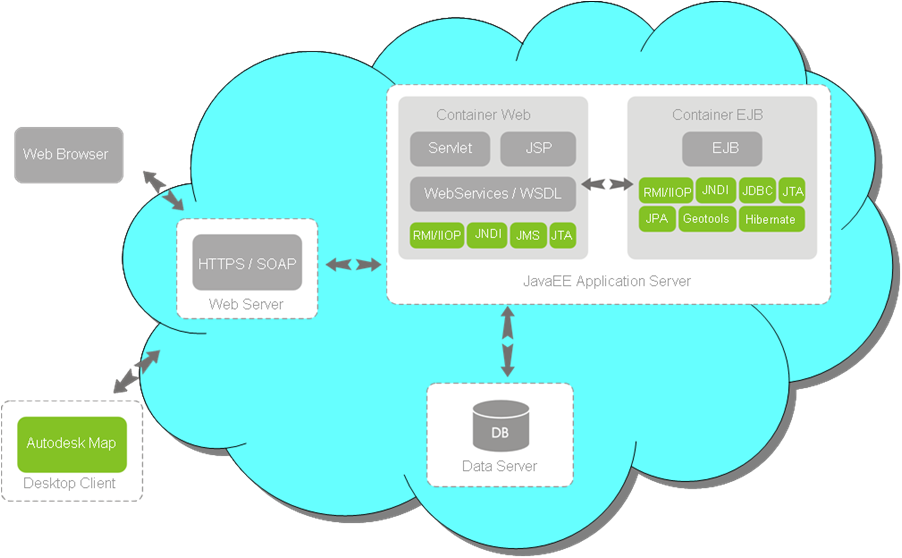 Geovane outlined a solution architecture that involves a database centric application based on open standards integrated in an N-tier architecture to optimize server usage and scalability. It uses secure web services to exchange data between the SaaS server and client applications. The server side requires enhanced performance logic to minimize network latency and optimize communications bandwidth so that client performance is similar to locally hosted infrastructure GIS applications. The application platform needs to support an industry-standard CAD/GIS front end for design such as AutoCAD Map3D as well as browser-based web clients.

Be the first to comment