• facebook
  • Twitter
  • Linkedin
  • Youtube
  • Linkedin Group
  • Post a Job
  • Post an Ad
  • Post an Event
  • Post a Directory Listing
  • Post a Press Release
  • Media Kit
  • My Account
  • Login
GoGeomatics
  • MAGAZINE
    • BIM & GIS
    • Community
    • Conference news
    • Earth Observation
    • Education & Careers
    • GEOAI
    • Announcements
    • Reality Capture & Lidar
    • Science
    • Technology
    • Between the Poles
  • Directories
    • ASSOCIATION
    • INDUSTRY
    • EDUCATION
    • Open Data
  • EVENTS
    • GeoIgnite Events
    • Events Calendar
    • GoGeomatics Meetups
  • Services
    • Advertising
    • Marketing
    • Post a Job
    • Post an Ad
    • Post an Event
    • Post a Press Release
    • Post a Directory Listing
    • Media Kit
    • Web Design
  • Find a Job
  • Volunteer
    • Start a GoGeomatics Group
    • Editors & Writers Group
  • About Us
    • About Us
    • Contact Us
    • Frequently Asked Questions
  • Videos
HomeBetween the Poles – The Geoff Zeiss ArchivesValue of spatial data

Value of spatial data

Between the Poles – The Geoff Zeiss Archives

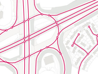
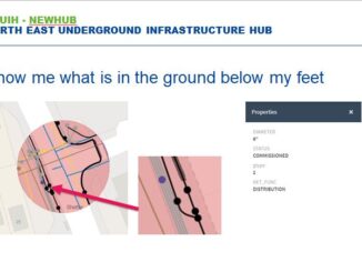
UK pilots demonstrate secure platform for sharing information about underground utility networks

16 January 2020 Geoff Zeiss

In the 2017 autumn budget the Chancellor of the Exchequer announced an important initiative to increase the value of the contribution of spatial data to the UK economy. The Geospatial Commission was created in the […]

3D data

National underground infrastructure map could deliver £245 million per year to UK

2 May 2019 Geoff Zeiss

The Geospatial Commission’s Annual Plan 2019/20 describes the activities that it plans to undertake in 2019/2020 to develop the UK’s National Geospatial Strategy.  The first project announced for 2019/2020 is its intention to fund two […]

3D cadastre

US 3D elevation project as a model for a national infrastructure map

24 September 2018 Geoff Zeiss

A number of years ago an initiative was funded under the ARRA economic stimulus package to initiate what was then called LiDAR for the Nation.  This has resulted in a USGS initiative called 3D Elevation […]

Access to Spatial Data

UK Mastermap to be made freely available

13 June 2018 Geoff Zeiss

As part of the Prime Minister’s London Tech Week roundtable, the UK Government has announced that key parts of the OS MasterMap will be made openly available for the public and businesses to use. OS […]

Access to Spatial Data

UK’s Geospatial Commission could play a role in the digital transformation of construction

28 May 2018 Geoff Zeiss

Governments are consolidating the role of geospatial data and technology in central governments. I have blogged about the Geospatial Data Act of 2017 in the U.S. Studies of the value of spatial data  and technology […]

Between the Poles – The Geoff Zeiss Archives

Studies find geospatial proliferating across the world economy

2 January 2018 Geoff Zeiss

The latest estimate of the annual contribution of the geospatial industry to the world economy of US$400 billion represents a substantial increase over a previous estimate of US$150-270 billion released in 2013.  Both reports agree that […]

Between the Poles – The Geoff Zeiss Archives

Geospatial contributes $21 billion to the Canadian GDP

5 May 2015 Geoff Zeiss

Prashant Shukle, Director General of Canada Centre for Mapping and Earth Observation (CCMEO) at Natural Resources Canada, invited the Canadian geospatial community to a pre-release discussion of the just released Canadian Geomatics Environmental Scan and Economic […]

Between the Poles – The Geoff Zeiss Archives

Geospatial contributed €69.3-million directly to the Irish economy in 2012

25 June 2014 Geoff Zeiss

A report commissioned by Ordnance Survey Ireland (OSi) and carried out by Indecon International Economic Consultants estimates that the geospatial information industry directly contributed €69.3-million (Gross Added Value) to the Irish economy in 2012.    […]

Posts pagination

1 2 3 »

Events

Feb 16
February 16 @ 8:00 am - February 18 @ 5:00 pm

GeoWeek 2026

Feb 17
5:00 pm - 8:00 pm

Victoria GoGeomatics February Mappy Hour

Feb 17
6:00 pm - 8:00 pm

Calgary GoGeomatics February Social

Feb 18
6:30 pm - 8:30 pm

Vancouver GoGeomatics Meetup – February 2026

Feb 19
February 19 - February 22

Spatial Knowledge and Information Canada 2026

View Calendar

View All Events

Services

  • Post a Job
  • Post an Ad
  • Post an Event
  • Post a Directory Listing
  • Post a Press Release
  • Media Kit
  • My Account
  • Login

Jobs

Post a Job
  • Volunteer Editorial Contributor – Be Part of Canada’s Geomatics Story
    Remote
  • Junior Geomatics Field Technician – Technical Surveys
    Montréal, QC
  • GIS Specialist
    Amherst, Nova Scotia
  • Precast Structural BIM Specialist
    Calgary, Alberta
View All Jobs
  • Directories
    • Associations Directory
    • Industry Directory
    • Education Programs
    • Open Data
  • Volunteer
    • Start a GoGeomatics Group
    • Editors & Writers Group
  • About Us
    • GoGeomatics Media Kit
    • Who We Are
    • Contact Us
    • FAQ’s
    • Advertising
    • Marketing
  • Subscribe
GoGeomatics
GoGeomatics is the largest and most popular communications hub promoting the Canadian geospatial community. The business was incorporated in 2011. GoGeomatics hosts over 100 fun, free, location technology networking events each year in cities across Canada.

© 2026 GoGeomatics

  • facebook
  • Twitter
  • Linkedin
  • Youtube
  • Linkedin Group