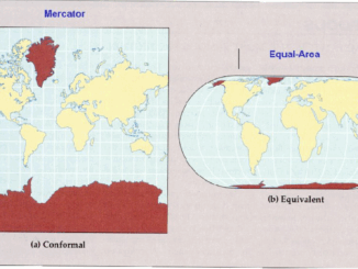
• facebook
  • Twitter
  • Linkedin
  • Youtube
  • Linkedin Group
  • Post a Job
  • Post an Ad
  • Post an Event
  • Post a Directory Listing
  • Post a Press Release
  • Media Kit
  • My Account
  • Login
GoGeomatics
  • MAGAZINE
    • BIM & GIS
    • Community
    • Conference news
    • Earth Observation
    • Education & Careers
    • GEOAI
    • Announcements
    • Reality Capture & Lidar
    • Science
    • Technology
  • Directories
    • ASSOCIATION
    • INDUSTRY
    • EDUCATION
    • Open Data
  • EVENTS
    • GeoIgnite Events
    • Events Calendar
    • GoGeomatics Meetups
  • Services
    • Advertising
    • Marketing
    • Post a Job
    • Post an Ad
    • Post an Event
    • Post a Press Release
    • Post a Directory Listing
    • Media Kit
    • Web Design
  • Find a Job
  • Volunteer
    • Start a GoGeomatics Group
    • Editors & Writers Group
  • About Us
    • About Us
    • Contact Us
    • Frequently Asked Questions
  • Videos
HomeCommunity

Community

Chris De Haan
BIM & GIS

Bill C-5, Federal Licensure, and the Surveying Workforce: ACLS President Chris de Haan Weighs In

28 August 2025 Anusuya Datta | ACLS

Bill C-5, the Free Trade and Labour Mobility in Canada Act, has sparked debate and some confusion in Canada’s surveying community — particularly around whether it affects the long-standing requirement for federal licensure. To clarify […]

BIM & GIS

From Mercator to Equal Earth: A Turning Point in Map Representation?

27 August 2025 Benedicta Antwi Boasiako | #GeospatialCommunity

When we look at a map, it feels like we are seeing the world as it is. Oceans, continents, and countries laid out neatly on a page or a screen. But every map is a […]

Digest Aug 25
Community

International Geospatial Digest – August 25, 2025

25 August 2025 Volunteer Editors and Group Writers | AI for geospatial

NOAA Upheaval Raises Concerns as U.S. Nears Peak Hurricane Season India’s Private Space Industry to Launch 12-Satellite EO Network Under PPP What’s Next for Landsat and Civilian Earth Observation Mapping the Future: Google AlphaEarth Foundations […]

Canada infra
BIM & GIS

Canada to Establish Federal Major Projects Office

25 August 2025 GoGeomatics Canada | #highways

Prime Minister Mark Carney announced last week that the federal government will establish a Federal Major Projects Office to oversee and expedite projects designated as being in the national interest under the new Building Canada […]

BIM & GIS

Take the Survey: Geomatics, Procurement, and Canada’s Infrastructure Push

21 August 2025 GoGeomatics Canada | business

Canada is embarking on one of the largest infrastructure investments in its history — dedicating 1.5% of GDP to critical infrastructure as part of a broader 5% commitment in defence. This scale of spending represents […]

Community

Canada’s National Geomatics Awards 2025: Cast Your Vote

18 August 2025 GoGeomatics Canada | business

Earlier this year, we invited Canada’s geomatics and geospatial community to nominate the individuals and organizations making a real difference in our sector. Now it’s time to make the final call for the Canada’s National […]

Meetups2
BIM & GIS

GoGeomatics: Empowering Canada’s Geospatial/BIM Community from Coast to Coast

18 August 2025 Volunteer Editors and Group Writers | Canadian Geospatial

GoGeomatics networking socials have grown into the beating heart of Canada’s geospatial community. Every month (except summer), professionals, students, and enthusiasts gather to share knowledge, spark collaborations, and build lasting relationships. What began as a […]

Digest Aug 18, 2025
Community

Canadian Geospatial Digest – August 18, 2025

18 August 2025 GoGeomatics Canada | Arctic Security

Mapping the Contested Arctic Feedback on Canada’s Internal Trade Legislation New Report Examines Link Between Murdered and Missing Indigenous Women and Human Trafficking in Canada CTV News Web Map Highlights Wildfires in Canada Satellite Imagery […]

Posts pagination

« 1 … 8 9 10 … 130 »

Events

Notice
There are no upcoming events.

View All Events

Services

  • Post a Job
  • Post an Ad
  • Post an Event
  • Post a Directory Listing
  • Post a Press Release
  • Media Kit
  • My Account
  • Login

Jobs

Post a Job
  • Canada Maps and Poster Gallery Volunteer Leads — GeoIgnite 2026
    remote
  • Software Engineer – Geographic Information System (GIS)
    Ottawa, ON
  • GIS Data Quality Analyst
    Burnaby, British Columbia
  • GIS Cartographer
    Montreal, QC
View All Jobs
  • Directories
    • Associations Directory
    • Industry Directory
    • Education Programs
    • Open Data
  • Volunteer
    • Start a GoGeomatics Group
    • Editors & Writers Group
  • About Us
    • GoGeomatics Media Kit
    • Who We Are
    • Contact Us
    • FAQ’s
    • Advertising
    • Marketing
  • Subscribe
GoGeomatics
GoGeomatics is the largest and most popular communications hub promoting the Canadian geospatial community. The business was incorporated in 2011. GoGeomatics hosts over 100 fun, free, location technology networking events each year in cities across Canada.

© 2025 GoGeomatics

  • facebook
  • Twitter
  • Linkedin
  • Youtube
  • Linkedin Group