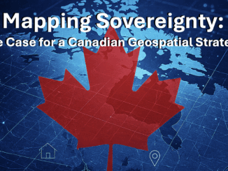
• facebook
  • Twitter
  • Linkedin
  • Youtube
  • Linkedin Group
  • Post a Job
  • Post an Ad
  • Post an Event
  • Post a Directory Listing
  • Post a Press Release
  • Media Kit
  • My Account
  • Login
GoGeomatics
  • MAGAZINE
    • BIM & GIS
    • Community
    • Conference news
    • Earth Observation
    • Education & Careers
    • GEOAI
    • Announcements
    • Reality Capture & Lidar
    • Science
    • Technology
  • Directories
    • ASSOCIATION
    • INDUSTRY
    • EDUCATION
    • Open Data
  • EVENTS
    • GeoIgnite Events
    • Events Calendar
    • GoGeomatics Meetups
  • Services
    • Advertising
    • Marketing
    • Post a Job
    • Post an Ad
    • Post an Event
    • Post a Press Release
    • Post a Directory Listing
    • Media Kit
    • Web Design
  • Find a Job
  • Volunteer
    • Start a GoGeomatics Group
    • Editors & Writers Group
  • About Us
    • About Us
    • Contact Us
    • Frequently Asked Questions
  • Videos
HomeGEOAI

GEOAI

Community

Compartmentalizing the Flames: A New Approach to Wildfire Management

8 September 2025 Alefiya Dungrawala | AI-model

Is wildfire spread random? It looks like that, but it isn’t. In fact, it follows the invisible geometry of landscapes: slopes, vegetation density, and wind corridors. Managing these patterns is a spatial problem. A recent […]

GEOAI

The Cooperative National Geologic Map: A Tool for Science, Safety, and Society

8 September 2025 Farzaneh Farshad | #GeospatialData

The U.S. Geological Survey (USGS) has released a new interactive web tool, The Cooperative National Geologic Map, the most detailed national-scale geologic map of the United States to date. Geologic maps serve many purposes. They […]

Digest Sept 8
Community

International Geospatial Digest – September 8, 2025

8 September 2025 Volunteer Editors and Group Writers | #GeospatialData

When the Government Can See Everything: Palantir’s Secretive Data Mapping Puts Civil Liberties at Risk Who Owns Canada’s Data? The Challenge of U.S. Cloud Control Does the Sky Belong to Us or Satellites? Hema Maps: […]

Peter Rabley
BIM & GIS

Owning the Future: A Conversation with Peter Rabley on AI, Digital Infrastructure, and the Battle for Trust

5 September 2025 David Legris | business

Artificial intelligence is no longer a distant prospect in the geospatial world — it’s here, reshaping how we collect, analyze, and act on location-based information. From accelerating disaster response to optimizing supply chains, the potential […]

Peter Srajer
BIM & GIS

“Risk-Aversion Is Shutting Out Innovation”: Peter Srajer on Procurement and Canada’s Big Build Plans

4 September 2025 Anusuya Datta | business

This interview is part of our GoGeomatics series on Canada’s infrastructure moment and its impact on the geospatial/geomatics sector. Canada has announced one of the most ambitious infrastructure commitments in its history: 5% of GDP […]

Bryn Fosburgh
Community

Beyond Hype: Geomatics & AI Program at GoGeomatics Expo 2025

4 September 2025 GoGeomatics Canada | Artificial Intelligence

The GoGeomatics Expo 2025 returns to Calgary from November 3-5, bringing Canada’s geomatics and geospatial communities together for three days of dialogue, networking, and collaboration. One of the most anticipated tracks this year is Beyond […]

Spargeo
Conference news

Sparkgeo Joins GoGeomatics Expo 2025 as Bronze Sponsor

3 September 2025 GoGeomatics Canada | Bronze Sponsor

Sparkgeo is joining the GoGeomatics Expo 2025 as a Bronze Sponsor. The Expo, Canada’s premier national geospatial event, will take place November 3–5, 2025, in Calgary, Alberta. The GoGeomatics Expo brings together professionals from across […]

Source: canadiangis.com
BIM & GIS

Support the Next Generation of GIS Professionals: Sponsor a BCIT Student

1 September 2025 Kruti Mehta | 2026

BCIT GIS Students Seeking Project and Practicum Sponsors for 2026 As the summer winds down, excitement is already building at the British Columbia Institute of Technology (BCIT) as another full cohort of students prepares to […]

Posts pagination

« 1 … 4 5 6 … 15 »

Events

May 25
May 25, 2026 - May 28, 2026

National Surveyors’ Conference 2026

Jun 1
June 1, 2026 - June 4, 2026

CAG/CARTO Annual Meeting 2026

Jul 4
July 4, 2026 @ 8:00 am - July 11, 2026 @ 5:00 pm

ISPRS Congress 2026

Sep 15
September 15, 2026 - September 17, 2026

INTERGEO 2026

Sep 16
September 16, 2026 - September 17, 2026

Join ALL IN 2026, Montreal, Canada

View Calendar

View All Events

Services

  • Post a Job
  • Post an Ad
  • Post an Event
  • Post a Directory Listing
  • Post a Press Release
  • Media Kit
  • My Account
  • Login

Jobs

Post a Job
  • Canada Maps and Poster Gallery Volunteer Leads — GeoIgnite 2026
    remote
  • GIS Data Quality Analyst
    Burnaby, British Columbia
  • GIS Cartographer
    Montreal, QC
  • SENIOR PLANNER SPATIAL ANALYSIS SIPA
    Toronto, ON
View All Jobs
  • Directories
    • Associations Directory
    • Industry Directory
    • Education Programs
    • Open Data
  • Volunteer
    • Start a GoGeomatics Group
    • Editors & Writers Group
  • About Us
    • GoGeomatics Media Kit
    • Who We Are
    • Contact Us
    • FAQ’s
    • Advertising
    • Marketing
  • Subscribe
GoGeomatics
GoGeomatics is the largest and most popular communications hub promoting the Canadian geospatial community. The business was incorporated in 2011. GoGeomatics hosts over 100 fun, free, location technology networking events each year in cities across Canada.

© 2025 GoGeomatics

  • facebook
  • Twitter
  • Linkedin
  • Youtube
  • Linkedin Group