• facebook
  • Twitter
  • Linkedin
  • Youtube
  • Linkedin Group
  • Post a Job
  • Post an Ad
  • Post an Event
  • Post a Directory Listing
  • Post a Press Release
  • Media Kit
  • My Account
  • Login
GoGeomatics
  • MAGAZINE
    • BIM & GIS
    • Community
    • Conference news
    • Earth Observation
    • Education & Careers
    • GEOAI
    • Announcements
    • Reality Capture & Lidar
    • Science
    • Technology
    • Between the Poles
  • Directories
    • ASSOCIATION
    • INDUSTRY
    • EDUCATION
    • Open Data
  • EVENTS
    • GeoIgnite Events
    • Events Calendar
    • GoGeomatics Meetups
  • Services
    • Advertising
    • Marketing
    • Post a Job
    • Post an Ad
    • Post an Event
    • Post a Press Release
    • Post a Directory Listing
    • Media Kit
    • Web Design
  • Find a Job
  • Volunteer
    • Start a GoGeomatics Group
    • Editors & Writers Group
  • About Us
    • About Us
    • Contact Us
    • Frequently Asked Questions
  • Videos

Magazine

Between the Poles – The Geoff Zeiss Archives

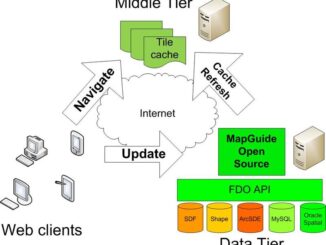
Architectural Design Pattern for Web Mapping with an Open Source Implementation

23 August 2008 Geoff Zeiss

One of the advantages of travelling as much as I do, is that I have a high probability of meeting interesting people who are doing very innovative things.  I’m currently in Australia to attend next […]

Between the Poles – The Geoff Zeiss Archives

Autodesk Signs Agreement To Acquire 3D Geo GMBH

11 August 2008 Geoff Zeiss

Autodesk announced that it has signed an agreement to acquire substantially all of the assets of the 3D Geo GmbH. 3D Geo is a leading provider of geo visualization and software to create, analyze, manage […]

Between the Poles – The Geoff Zeiss Archives

Province of Ontario Protects 50% of Boreal Forest

11 August 2008 Geoff Zeiss

The Premier of Ontario has announced  that the Province has committed to protect 50% of the Province’s intact northern boreal forest, amounting to 225,000 square kilometers, or 43% of the land mass of Ontario. This […]

No Picture
Between the Poles – The Geoff Zeiss Archives

How to Get CS-Map Coordinate System Software Source

8 August 2008 Geoff Zeiss

I have received a number of queries asking when and where the CS-Map source code will be available.  It is available now and you can find it at CS-MAP source tree. To download the source […]

No Picture
Access to Spatial Data

SQL Server 2008 Spatial and FDO

7 August 2008 Geoff Zeiss

Microsoft has announced the Release to Manufacturing of SQL Server 2008.  From a geospatial perspective the most important aspect of SQL Server 2008 is spatial data types and spatial indexing.  At this point, all the […]

Between the Poles – The Geoff Zeiss Archives

Autodesk Contributes Mentor Software CS-Map Coordinate System Software to the Open Source Community

6 August 2008 Geoff Zeiss

Software Donations Autodesk has announced another major software donation to the Open Source Geospatial Foundation (OSGEO) . The source code for the CS-Map coordinate system technology acquired from Mentor Software has been donated to the […]

Access to Spatial Data

Formation of the Open Web Foundation

29 July 2008 Geoff Zeiss

Last week at OSCON, David Recordon gave a presentation in which he announced the creation of the Open Web Foundation. The Open Web Foundation appears to be modeled on the Apache Software Foundation, with the […]

Access to Spatial Data

Google Encouraging Governments to Make Geospatial Data Available on Google Earth: Government of BC First In Canada

28 July 2008 Geoff Zeiss

According to a Vancouver Sun article , British Columbia Agriculture and Lands Minister Stan Hagen announced that GeoBC will provide access to the province’s geographic database on Google so that you can access this database […]

Posts pagination

« 1 … 674 675 676 … 693 »

Events

Notice
There are no upcoming events.

View All Events

Services

  • Post a Job
  • Post an Ad
  • Post an Event
  • Post a Directory Listing
  • Post a Press Release
  • Media Kit
  • My Account
  • Login

Jobs

Post a Job
  • Operations Spatial Data Assistant (Contract)
    Vaughan
  • GIS Analyst
    Saint John, New Brunswick
  • GIS Student Intern
    Elmsdale, Nova Scotia
  • Canada Impact+ Research Chair – Professor (Or Associate Professor)
    Lethbridge, Alberta
View All Jobs
  • Directories
    • Associations Directory
    • Industry Directory
    • Education Programs
    • Open Data
  • Volunteer
    • Start a GoGeomatics Group
    • Editors & Writers Group
  • About Us
    • GoGeomatics Media Kit
    • Who We Are
    • Contact Us
    • FAQ’s
    • Advertising
    • Marketing
  • Subscribe
GoGeomatics
GoGeomatics is the largest and most popular communications hub promoting the Canadian geospatial community. The business was incorporated in 2011. GoGeomatics hosts over 100 fun, free, location technology networking events each year in cities across Canada.

© 2026 GoGeomatics

  • facebook
  • Twitter
  • Linkedin
  • Youtube
  • Linkedin Group