
The Royal Canadian Geographical Society (RCGS) has unveiled a bold new globe at its Ottawa headquarters. The five-foot sphere, nicknamed the Canada Globe, was handcrafted by Bellerby & Co., renowned British globe makers, and gifted by the Oughtred family, according to The Globe and Mail.
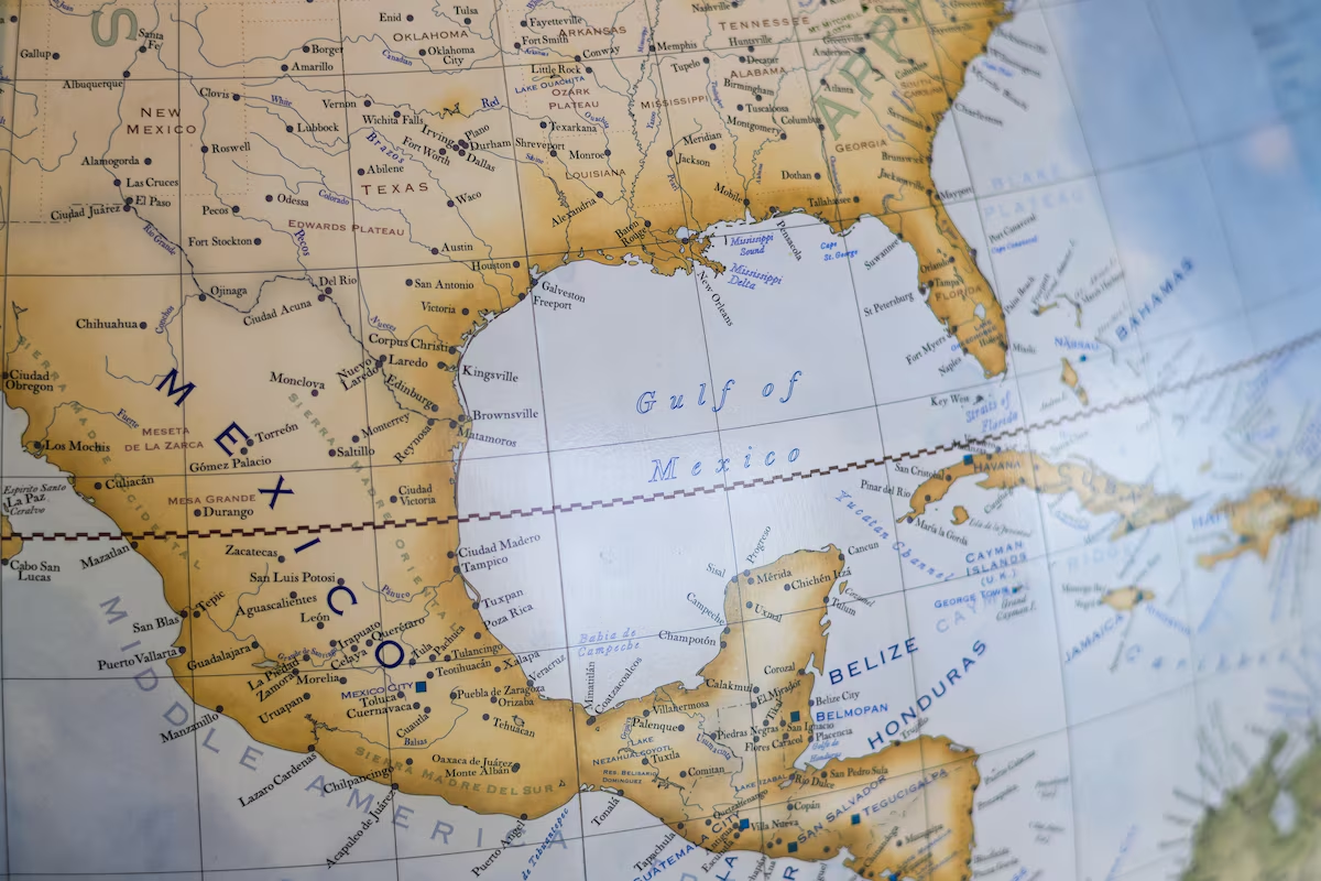
More than a work of cartographic beauty, the globe is meant to highlight Canada’s sovereignty. It does so by intentionally including Denali, North America’s tallest mountain, under its Indigenous name, as well as the Gulf of Mexico—choices that subtly push back against recent U.S. efforts to rewrite geographic names.
A Globe Designed to Stand Out
The Canada Globe stands out for its superb craftsmanship and dramatic use of imperial pink to shade Canada, an intended break from the traditional uniform colour of North America on globes. According to RCGS CEO John Geiger, the Society directed the producers to make Canada stand out from its powerful neighbour. The purpose was to highlight Canada’s global significance and stir discussions about geography, politics, and cultural identity.
Along with its vibrant colours, the globe bears the Society’s coat of arms and the slogan *Ducit Amor Patriae* (“Love of country leads me”). Its creation follows another symbolic initiative in 2025, when the Royal Canadian Geographic Society placed a giant floor map of Canada in London’s Trafalgar Square to commemorate the centennial of Canada’s High Commission building.
U.S. Renaming Orders and Their Ripple Effects
The unveiling also comes as the United States pursues controversial changes to international naming conventions. Shortly after taking office, President Donald Trump issued an Executive Order, titled “Restoring Names That Honour American Greatness”, which instructed federal agencies to rename Denali to its previous colonial name, Mount McKinley, and to refer to the Gulf of Mexico as the Gulf of America.
While supporters argued that the order celebrated American history, many Alaskans, Indigenous groups, and international bodies raised objections. They noted that “Denali” means “the high one” in Athabaskan and that the Gulf’s name reflects centuries of shared history.
By intentionally including Denali and the Gulf of Mexico on its globe, the RCGS sends out the message that Canadian geography will not automatically follow politically motivated renaming abroad. It’s a subtle declaration of cartographic independence.
When Digital Maps Get It Wrong
American attempts to control place names don’t just come from government orders — they also show up in tech. Google was quick to change its maps after President Trump’s executive order to rename the Gulf of Mexico to the “Gulf of America.” For U.S. users, Google Maps now shows “Gulf of America,” while in Mexico it stays “Gulf of Mexico,” and people elsewhere often see both names.
In February 2025, Global News reported that Canadian users were noticing that Google Maps had labeled Canadian provincial parks as “state parks.” Backlash erupted over the slip, which was most likely caused by a data-schema fault with the platform’s U.S.-centric basemap. Google admitted the error and vowed to update its phrasing to match Canadian names like “provincial park” or “territorial park.”
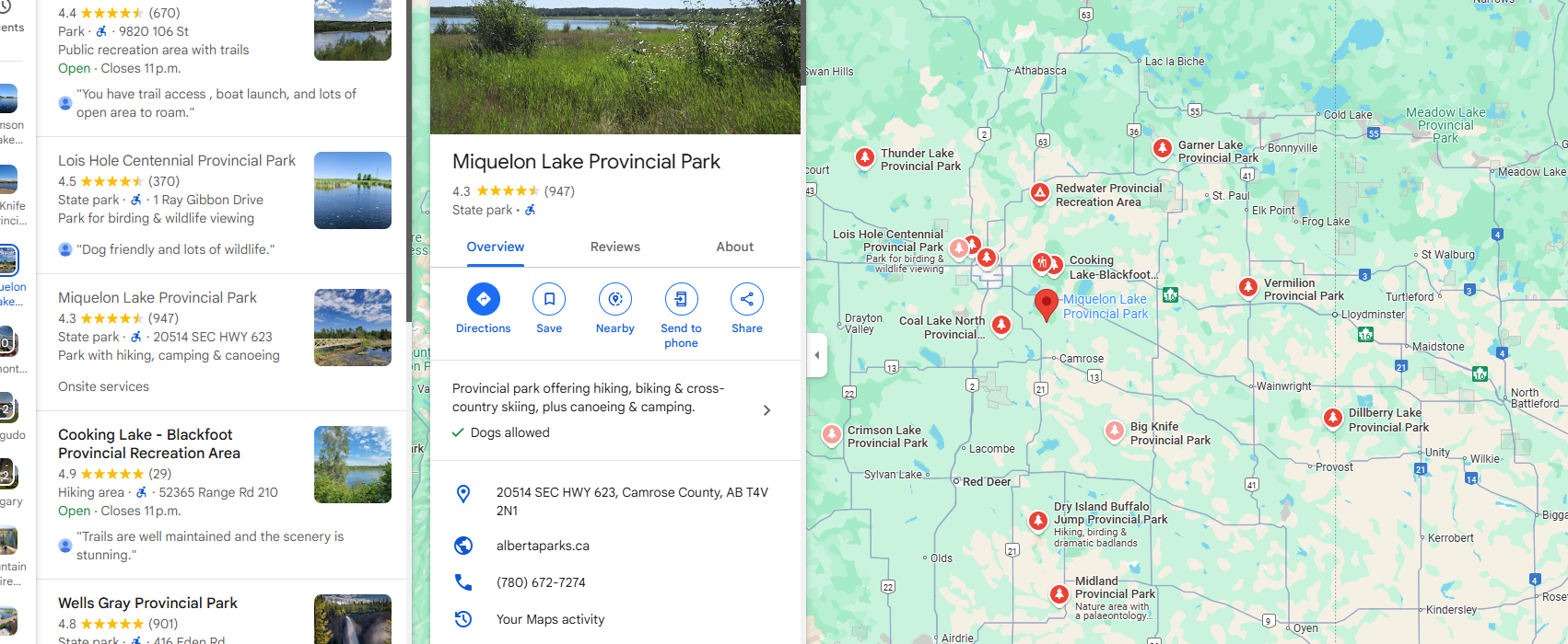
The controversy continued for some time as Canadians kept reporting the mistake, and it remains unclear if every mislabeled park has been corrected.
Although less dramatic than an executive order, these glitches demonstrate how digital platforms can shape geographic literacy and even touch on questions of national sovereignty. A single mislabel can subtly make inaccurate terms seem normal—especially on services used by millions every day.
Why Maps and Place Names Matter
The controversies over renaming and mislabelling point to a deeper truth: maps are never neutral. They are cultural documents. A name on a globe, in a database, or on a phone screen communicates history, politics, and identity. Names like Denali help Indigenous groups preserve their language and understanding of the land. Map labelling can either strengthen or weaken national sovereignty.
The RCGS Canada Globe calls on viewers to consider these interactions. Its colour scheme and labels serve as a reminder that geography is much more than just where things are. By presenting Canada in a unique way, the RCGS encourages geographic literacy and sparks debate regarding place name authority.
RELATED READ: Supporting Indigenous Datasets – A Conversation with Esri Canada
Implications for Educators, Platforms, and Policy Makers
The debates around renaming, digital glitches, and the unveiling of the Canada Globe all point to broader lessons:
- Stronger Place Name Standards: To honour varied histories, governments and mapping organizations may establish clearer rules for recognizing multiple names — official, Indigenous, and informal.
- Platform Accountability: Companies like Google must strike a balance between scale and sensitivity, ensuring localization respects regional languages and governance.
- Public Engagement with Geography: Exhibits like the Canada Globe can prompt residents to consider how maps are created, who controls labelling, and why such decisions are important.
- Data Stewardship in GIS: For geospatial professionals, maintaining alternate names and sources in datasets helps reduce confusion and ensure cultural accuracy across apps and publications.
The Royal Canadian Geographical Society’s new globe is more than just a decorative piece; it is a statement about Canada’s place in world cartography. The globe reinforces how maps impact people’s perceptions of nations, towns, and history by opposing politically motivated renaming and emphasizing local nomenclature.
The politics of place names remind us that geography is never static, but rather a living narrative printed on paper, screens, and, now, a vivid imperial-pink globe in Ottawa.


Be the first to comment