
Using location-based information and geospatial data to solve problems is not a new idea, but the variety in types of applications being created and used in virtually every industry has grown exponentially in recent years. Businesses are realizing the value of adding a “geo” aspect or mapping part to their analytics to view ROI, increase productivity, improve marketing efforts, and make more strategic business decisions overall. From agriculture to insurance, defense to conservation, mining to banking, geospatial data is more important than ever before to solve real-world problems.
“In five years, there may be a million times more than the amount of geospatial data that we have today.” That’s a quote from 2017, and it was said by Robert Cardillo, director of the National Geospatial-Intelligence Agency. And as the number of data sources continues to increase, artificial intelligence, machine learning, and deep learning are becoming more and more important. There aren’t enough image analysts to process all the data manually, so we need new and smarter ways to put computers to work for us.
Geographic imaging professionals need to process vast amounts of geospatial data every day — often relying on software designed for other purposes and add-on applications that create almost as many problems as they solve. But users can save both time and money, leverage existing data investments, and improve their image analysis capabilities by using ERDAS IMAGINE, a Hexagon product.
ERDAS IMAGINE provides true value, consolidating remote sensing, photogrammetry, LiDAR analysis, basic vector analysis, and radar processing into a single solution. And ERDAS IMAGINE continues to stand up in today’s remote sensing commercial software market for a number of reasons.
45+ years of remote sensing algorithms and expertise. Over the years, ERDAS IMAGINE has remained the leader in the global remote sensing market. Its algorithms are dependably accurate, and every new release includes all the latest and greatest industry standard algorithms. Even as ERDAS IMAGINE evolves to meet the needs of the changing market, it maintains a high level of consistency and sophistication.
Productivity. True 64-bit processing makes use of multi-core computers and distributed processing, multi-threading, and GPU processing. As the amount of Big Data in the world continues to increase, optimizing software to optimize hardware usage is critical for maximum production.
Artificial intelligence, machine learning and deep learning. ERDAS IMAGINE continues to add industry standard AI, ML, and DL algorithms to every release and update. Inception, Random Forest, CART, and other classifiers are included. In addition to these algorithms, already available to use out of the box, ERDAS IMAGINE offers a Software Development Toolkit (SDK) to create or modify existing algorithms for use within the platform.
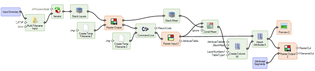
Spatial Modeler. ERDAS IMAGINE makes work configurable, repeatable, batchable, and extendable. Call Python scripts, use ArcPy or the command line, and preview results without running to disk. Spatial Modeler is at the heart of every ERDAS IMAGINE process, making it easy to string together multiple models to increase efficiency and streamline workflows.
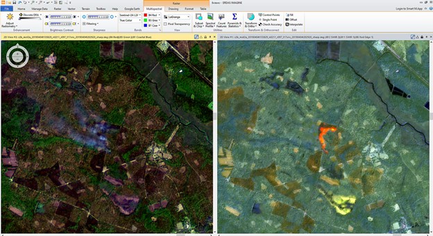
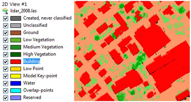
A unified workspace. ERDAS IMAGINE combines all geospatial data and processing into one toolkit.It can read 160+ formats natively and import virtually all others, including UAV imagery, aerial or satellite imagery, SAR/radar data, hyperspectral imagery, LiDAR and point clouds, vector data, and web services. ERDAS IMAGINE can handle any type of geospatial processing. Combine ERDAS IMAGINE’s versatility with the power of Spatial Modeler and the integration of Python, and it’s a true one-stop shop for desktop geospatial analysis. ERDAS IMAGINE is one package that does it all, and it does it well.
Data is a valuable commodity. With ERDAS IMAGINE, geospatial data gains even more worth. ERDAS IMAGINE helps users process information, unlock insights, and improve efficiency, and it makes working with location-based information easier than ever. With speed, flexibility, and a proven record of success, ERDAS IMAGINE is the image analysis solution of the future — it just happens to exist in the present.
Interested in learning more about ERDAS IMAGINE? Take a look at our on-demand webinar.


Be the first to comment