
Canada is entering a period of major national investment in infrastructure, digital transformation, and Arctic security. From infrastructure modernization and digital twins to Arctic monitoring and national security, geospatial technologies will play a critical role in how these initiatives are delivered.
At the same time, the geomatics and geospatial sector is changing quickly. Artificial intelligence is reshaping workflows, procurement systems are under pressure to support innovation, and questions are emerging about Canada’s sovereign geospatial capabilities and data infrastructure.
To better understand where the sector stands today, GoGeomatics has launched a new national survey: The State of Canada’s Geospatial Capability Survey.
The survey invites professionals from across government, industry, and academia to share their perspectives on the opportunities and challenges shaping the future of the sector.
Building on Previous Industry Surveys
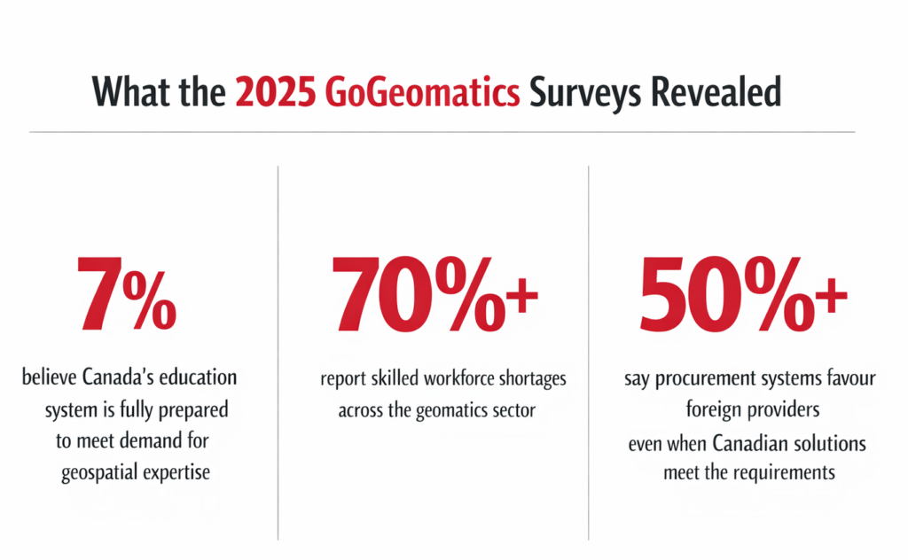
This new survey builds on earlier GoGeomatics research examining geomatics education, workforce development, and procurement in Canada. Those surveys revealed several important concerns within the community.
Previous surveys revealed several concerning trends. Only about 7 percent of respondents believed Canada’s education system was fully prepared to meet the growing demand for geospatial expertise, more than 70 percent reported skilled workforce shortages, and over half said procurement systems often favour foreign providers even when Canadian solutions meet the requirements.
These findings highlighted growing concern within the sector about Canada’s long term geospatial capacity and reinforced the need for continued industry dialogue.
What This Year’s Survey Will Explore
The goal of this year’s survey is to take a broader look at Canada’s geospatial capability and how the sector views the country’s readiness for major infrastructure, digital transformation, sovereignty, and national security priorities.
The survey explores issues including Canada’s economic and infrastructure outlook, the role of geomatics in national development, whether procurement systems support innovation and Canadian developed solutions, the importance of sovereign geospatial infrastructure, how artificial intelligence is changing geospatial workflows, and what priorities will strengthen Canada’s geospatial capability over the next decade.
At a time when Canada is placing greater emphasis on Arctic sovereignty, national capability, digital infrastructure, and resilience, these questions are becoming more important. Geospatial technologies sit at the centre of many of these national priorities, yet the sector still faces persistent questions around readiness, awareness, capacity, and long term investment.
Have Your Voice Heard
The survey takes about five to six minutes to complete.
Results will be shared with the community through GoGeomatics and will help inform discussions at GeoIgnite, Canada’s National Geospatial Leadership Conference taking place May 11 to 13 in Ottawa, as well as other industry gatherings including the GoGeomatics Expo.
The findings will also help shape conversations at the Open Canadian Geospatial Forum taking place on the first day of GeoIgnite. The forum is being delivered in collaboration with the Open Geospatial Consortium (OGC) and the OGC Canada Forum.
Professionals across government, industry, and academia are encouraged to participate and share their perspective.
A Community Effort
Day one (Monday May 11th) of GeoIgnite 2026 will feature the free to attend Canadian Geospatial and Geomatics Forum, delivered in collaboration with the Open Geospatial Consortium (OGC) and the OGC Canada Forum. The forum is designed as a vendor neutral gathering focused on the future of geospatial standards, national capability, and data infrastructure in Canada. Support for the Open Canadian Geospatial Forum is provided by Esri Canada. Monday is a free event we hope you attend and share your views.
GeoIgnite 2026 Sponsors
Gold Sponsor
Silver Sponsors

Bronze Sponsor
Lanyard & Lunch Sponsors

Association Sponsors


Be the first to comment