BIM & GIS
The Story Beneath the Map
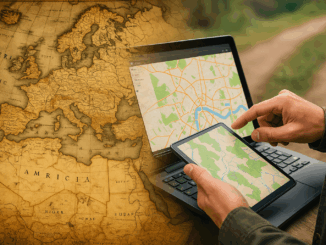
People open maps on their phones every day to check a route, locate a place, or understand what surrounds them. It feels simple, but a long history stands behind that moment. The journey to modern […]
People open maps on their phones every day to check a route, locate a place, or understand what surrounds them. It feels simple, but a long history stands behind that moment. The journey to modern […]

This interview is part of our series on Canada’s infrastructure moment and its impact on the geospatial/geomatics sector. “If you’re not an incumbent, you can’t even get in the door.” That’s how Will Cadell sums […]

The beginning of 2016 was accompanied with a sonorous press release from the Open Geospatial Consortium (OGC) entitled: “OGC® seeks public comment on a candidate standard that may replace legacy coordinate systems” [1]. In other […]
A new textbook on geographic information systems by GGE’s Professor Emmanuel Stefanakis has just been published by CreateSpace. Entitled Geographic Databases and Information Systems, its aim is to present geographic information systems from a technological […]
The newest version of MicroSurvey FieldGenius streamlines survey stakeout and simplifies project startup and instrument configuration for an instant productivity boost on every job. (West Kelowna, BC, Canada – July 22, 2014) – MicroSurvey has […]
Projections and Coordinate Systems for GIS: A new perspective on old ideas. (Or, GIS Professionals Should Consider That A Lot Of Our Constants Are, Increasingly, Not So Constant.) “I am constant as the northern star, Of […]
GoGeomatics Canada is looking to the west of Canada and speaking with Tracey Harvey GIS instructor at Selkirk College in BC. GoGeomatics: Hi Tracey and welcome back to the GoGeomatics Canada community. Tracey you were […]
We had the opportunity to talk with Mike Strutt about surveying and his career. Mike is one of the most experienced surveyors in Canada . began his survey career in 1974 and managed his first GPS project in 1987 while a field officer with the Geodetic Survey of Canada. Prior to joining Topcon where he now manages RTN Services, Support & Training, Mike spent in excess of 11 years and 10,000 hours delivering instruction on the use of GPS for surveying and mapping.
If you’re thinking about getting into surveying or just more about what a surveyor does this is a must read. […]