• facebook
  • Twitter
  • Linkedin
  • Youtube
  • Linkedin Group
  • Post a Job
  • Post an Ad
  • Post an Event
  • Post a Directory Listing
  • Post a Press Release
  • Media Kit
  • My Account
  • Login
GoGeomatics
  • MAGAZINE
    • BIM & GIS
    • Community
    • Conference news
    • Earth Observation
    • Education & Careers
    • GEOAI
    • Announcements
    • Reality Capture & Lidar
    • Science
    • Technology
  • Directories
    • ASSOCIATION
    • INDUSTRY
    • EDUCATION
    • Open Data
  • EVENTS
    • GeoIgnite Events
    • Events Calendar
    • GoGeomatics Meetups
  • Services
    • Advertising
    • Marketing
    • Post a Job
    • Post an Ad
    • Post an Event
    • Post a Press Release
    • Post a Directory Listing
    • Media Kit
    • Web Design
  • Find a Job
  • Volunteer
    • Start a GoGeomatics Group
    • Editors & Writers Group
  • About Us
    • About Us
    • Contact Us
    • Frequently Asked Questions
  • Videos
Homedisaster management

disaster management

NISAR Earth Satellite
Earth Observation

NISAR Releases First Radar Images: A New Phase Begins for the NASA–ISRO Mission

6 October 2025 Sree Vishnu Priya Donepudi | Agriculture Monitoring

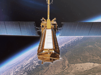
A Follow-Up to July’s Anticipation As previously reported in GoGeomatics’ July 2025 International Geospatial Digest, the NASA–ISRO Synthetic Aperture Radar (NISAR) mission was launched with great anticipation as one of the most powerful Earth-observing radar […]

Cassidy Rankine
Earth Observation

Mapping Crisis in Real Time: Cassidy Rankine on How Planet is Powering Canada’s Climate Response

9 June 2025 Anusuya Datta | Agriculture and Agri-Food Canada

As Canada enters yet another year of severe and increasingly frequent climate events — from early-season wildfires to flash floods and coastal erosion — governments are under growing pressure to adapt faster and act smarter. […]

VS
Conference news

A Lifetime in Radar: Dr. Vernon Singhroy on Innovation, Influence, and Mentorship

6 June 2025 Benedicta Antwi Boasiako | AI

Dr. Vernon Singhroy is Canada’s one of the most distinguished Earth Observation scientists, known globally for his expertise in Synthetic Aperture Radar (SAR) and remote sensing applications. Over his decades-long career, he has published more […]

France GIS|
BIM & GIS

France’s Open-Source GIS Journey: A Blueprint for Digital Sovereignty

4 April 2025 Anusuya Datta | disaster management

A €6 billion open-source software market (as of 2022), 1,062 local authorities publishing open geodata, and a 19% year-over-year increase in government data sharing. Behind these impressive numbers lies a deliberate national strategy on part […]

bsc video
BIM & GIS

Watch This Video: Empowering the Digital Workforce at GeoIgnite 2025

2 April 2025 GoGeomatics Canada | AEC

Date: May 12-14, 2025Location: Ottawa Conference and Event Centre, Ottawa, Canada At GeoIgnite 2025, buildingSMART Canada (bSC) is hosting an exciting program track titled Empowering the Digital Workforce: Boosting Productivity with AI, OpenBIM, and Information Standards. This […]

Conference news

Watch the Video: GeoIgnite 2025 – Advancements in Earth Observation Technologies and AI

24 March 2025 GoGeomatics Canada | AI

Date: May 12-14, 2025Location: Ottawa Conference and Event Centre, Ottawa, Canada GeoIgnite 2025 will highlight the latest advancements in Earth Observation (EO) technologies and Artificial Intelligence (AI) that are shaping the future of the geospatial […]

Canadian-digest-march-3||||
Community

Canadian Geospatial Digest for March 3, 2025

3 March 2025 Volunteer Editors and Group Writers | Canada

New Interactive Map Facilitates Identification of Territory Stakeholders in Quebec WildFireSat: Canada’s Satellite System to Revolutionize Northern Wildfire Monitoring Canada Updates Historical Flood Events Layer with Over 100 New Events Google Addresses Mislabeling of Canadian […]

Conference news

Natural Resources Canada to Participate in GeoIgnite 2025 and Lead Keynote Presentation

7 February 2025 GoGeomatics Canada | Artificial Intelligence

Ottawa, ON – GoGeomatics is pleased to announce the participation of Natural Resources Canada (NRCan) at GeoIgnite 2025, which is taking place from May 12-14, 2025, at the Ottawa Conference and Event Centre. NRCan’s contributions […]

Posts pagination

1 2 »

Events

Notice
There are no upcoming events.

View All Events

Services

  • Post a Job
  • Post an Ad
  • Post an Event
  • Post a Directory Listing
  • Post a Press Release
  • Media Kit
  • My Account
  • Login

Jobs

Post a Job
  • Canada Maps and Poster Gallery Volunteer Leads — GeoIgnite 2026
    remote
  • GIS & Data Analytics Lead
    Beaumont, AB
  • Lead Surveyor, Projects/Arpenteur-géomètre principal, projets; arpenteuse-géomètre principale, projets
    North Bay, Thunder Bay
  • Senior GIS Developer
    Calgary, AB
View All Jobs
  • Directories
    • Associations Directory
    • Industry Directory
    • Education Programs
    • Open Data
  • Volunteer
    • Start a GoGeomatics Group
    • Editors & Writers Group
  • About Us
    • GoGeomatics Media Kit
    • Who We Are
    • Contact Us
    • FAQ’s
    • Advertising
    • Marketing
  • Subscribe
GoGeomatics
GoGeomatics is the largest and most popular communications hub promoting the Canadian geospatial community. The business was incorporated in 2011. GoGeomatics hosts over 100 fun, free, location technology networking events each year in cities across Canada.

© 2025 GoGeomatics

  • facebook
  • Twitter
  • Linkedin
  • Youtube
  • Linkedin Group